All Activity
- Past hour
-
"When in doubt, forecast drought."
-

2026 Atlantic Hurricane Season
PhiEaglesfan712 replied to Stormchaserchuck1's topic in Tropical Headquarters
I think it was last year, we didn't have a TC from August 28-September 16. [The year before, we didn't have a TC from August 21-September 8.] -
CAD seems likely. I'm more interested in what may potentially develop in the Gulf or off the SE Coast. Euro and other models hinting at something. Potential heavy rains.
-
Without commenting on December, I find the Cfs2 site to be most up to date with forecasts. TT lags a bit. Unfortunately, the Cfs2 site doesn't provide H5 forecasts. Link is below. https://www.cpc.ncep.noaa.gov/products/CFSv2/CFSv2seasonal.shtml Fwiw, temp forecasts have been surprisingly consistent off the Cfs2 site for the last couple weeks in the M.A. Here's the current one. https://www.cpc.ncep.noaa.gov/products/CFSv2/htmls/usT2me3Mon.html
-

2026-2027 Record-breaking El Nino
40/70 Benchmark replied to Stormchaserchuck1's topic in Weather Forecasting and Discussion
Basically, high AAM means that the hemisphere is more representative of warm ENSO, low AAM cool ENSO. -

2026-2027 Record-breaking El Nino
soadforecasterx replied to Stormchaserchuck1's topic in Weather Forecasting and Discussion
Seems like we are still seeing some good heating going on to push this el nino stronger.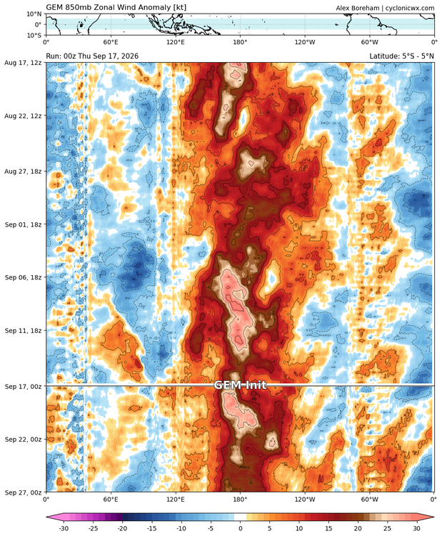
-

Pittsburgh PA Summer 2026 Thread
Gordo74 replied to TheClimateChanger's topic in Upstate New York/Pennsylvania
Might make e11 shirts to manifest that one into existence. -
 Hi everyone! I stumbled upon a really useful site and figured I'd pass it along. Check it out — https://silverwillow.com/. Would love your feedback
 -
2026-2027 Record-breaking El Nino
soadforecasterx replied to Stormchaserchuck1's topic in Weather Forecasting and Discussion
Climate Drivers: Anomalously high relative AAM values frequently occur during El Niño events and specific active phases of the Madden-Julian Oscillation (MJO) due to broad westerly wind anomalies in the tropics and subtropics. -

2026-2027 Record-breaking El Nino
mitchnick replied to Stormchaserchuck1's topic in Weather Forecasting and Discussion
Try "Global Relative AAM" -
The most glaring commonality between the QBO composite and both the solar and intense El Niño composites is the pronounced ridging stretching from the northeastern CONUS and into central Canada, which obviously is a rather mild signal for the forecast area in the seasonal mean. However, it has been mentioned on numerous occasions that neither of these winter composites are entirely bereft of high latitude blocking or even shorts bursts of severe winter weather. This is evident in the bifurcation of the composite below. This is a signal that is emergent among some seasonal guidance. What is clear is that as El Niño begins to wane and perhaps shift somewhat to the west as the season evolves, the Gulf of Alaska low begins to retrograde, which allows the central Canadian-Northeastern CONUS ridge to lift up into the NAO domain. This mid-to-latter season progression is the crux of the volatility and Modoki-like episode(s) that have been referenced with the respect the overall characterization of the polar domain. The primary risk here for a transition to a significantly colder pattern is that the block is more oriented towards the Eastern portion of the NAO domain, which is especially evident in the more meager El Niño analogs that did not have the very cohesive Gulf of Alaska low that is synonymous with El Niño. The inference is that the development of the more Modoki like intervals during the second half of the season is contingent on the progression of the mid latitudes of the northern Hemisphere growing more redolent of traditional El Niño as boreal winter ensues, which should take place given the forecast for this warm ENSO event to reach an unprecedented magnitude as Mother Nature gives her best shot at the redistribution of that stagnant west Pacific warm pool
-
Agreed. The frequency of events is almost certainly going to be lower than normal. The question is, will we be able to take advantage of the opportunities when they arise?
-
Totally reasonable....that ridge should lift up towards the NAO domain in January, as the GOA low retrogrades and forces the ridge away from the Aleutians.
-

Septorcher 2026 Discussion - Endless Summer
dendrite replied to Damage In Tolland's topic in New England
I was expecting some Marc Cohn. -
Septorcher 2026 Discussion - Endless Summer
dendrite replied to Damage In Tolland's topic in New England
WTTTE -
excellent, oktoberfest next saturday looks like it could be fun, will put on my list of potential stops...thanks!
-

2026-2027 Fall/Winter Mountain Thread
BlueRidgeFolklore replied to BlueRidgeFolklore's topic in Southeastern States
We may cool down next week afterall. https://x.com/SCweather_wx/status/2100592803881365715 -
Still getting lots of peppers , green beans and tomatoes of all sizes in garden . Some of the bell peppers are turning red which is the first time I’ve had that happen. All of the veggie plants have some new flower blooms on them too. With the warmth ahead I wonder how far into October/ November we can go .
-

Septorcher 2026 Discussion - Endless Summer
HoarfrostHubb replied to Damage In Tolland's topic in New England
Brand new road!!! It is so nice -
Make sure to hit Spyglass in Nashua . Fantastic
-
Agree. Hopefully we can time some cold air and a favorable storm track here and there to make it worthwhile.
-

2026 Atlantic Hurricane Season
olafminesaw replied to Stormchaserchuck1's topic in Tropical Headquarters
Any idea what the record is for longest streak without a TC in the Atlantic in September? -
I'd also bet the whole fall and winter are like that with the Nino
-
I would place a bet that some in this sub forum see more unwanted heavy to possibly excessive rainfall over the next 2 weeks. Next 2 weeks look to feature above normal rainfall region wide.
-

2026-2027 Record-breaking El Nino
adam7288 replied to Stormchaserchuck1's topic in Weather Forecasting and Discussion
Any chance you can explain what this means? Tried googling AAM nothing useful came up.