All Activity
- Past hour
-
Pouring out in bridgewater even though radar isn't all that impressive looking
-
Precip is light here in Central NJ - its drying up as it moves north - but making the atmosphere much more humid Heat Advisories and T -storms next couple of days at least - sounds like fun.
-
 Since 2017 the whole arctic (60-90N) is the leading indicator for Winter pattern 60-90N. It usually reverses.
 -
 sildenafil 50 mg price Sildoliko - buy viagra here
 -

2026-2027 Record-breaking El Nino
bluewave replied to Stormchaserchuck1's topic in Weather Forecasting and Discussion
2024 and 2025 didn’t have the deep trough north of Alaska like this June and July. It was displaced closer to Greenland and not as strong. Could be a result of the rebound following the stratospheric warming event last November. -

Augdewst 2026: Summer's Last Stand
Damage In Tolland replied to Prismshine Productions's topic in New England
What do you know . Dews are 70 . Now who would have thought ?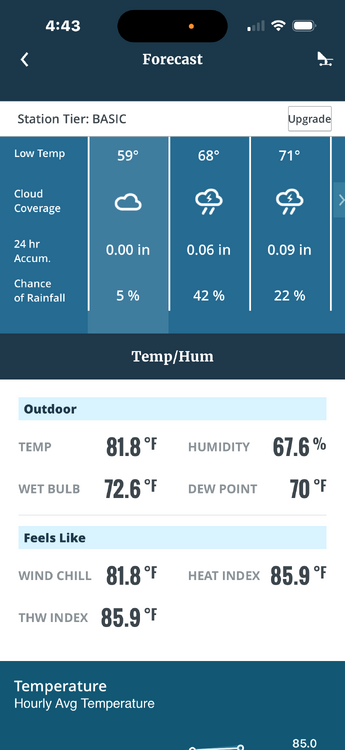
-
Nice post. Record breaking El Nino it is! This Winter will be an interesting data point! I love extremes, gives a lot of information.
-
Yeah, give me a Super Nino STJ in -NAO/AO. I'm leaning towards above average snowfall right now.
-
I'm loving the -500mb over the Arctic this warm season. 2024 and 2025 are actually good analogs there, and they both had Winter ridging 60-90N.
-
It is. I can’t stand the ex hubby either. Now he is after the money by taking this shoddy stance in order to maximize lawsuits later.
-
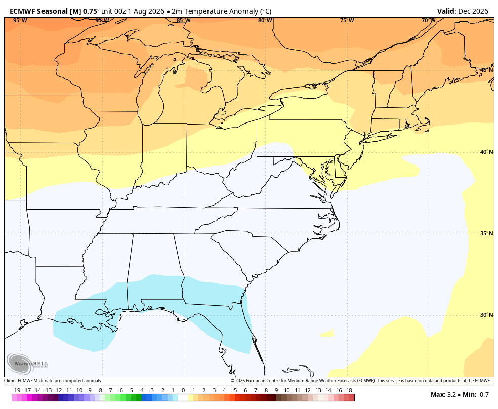
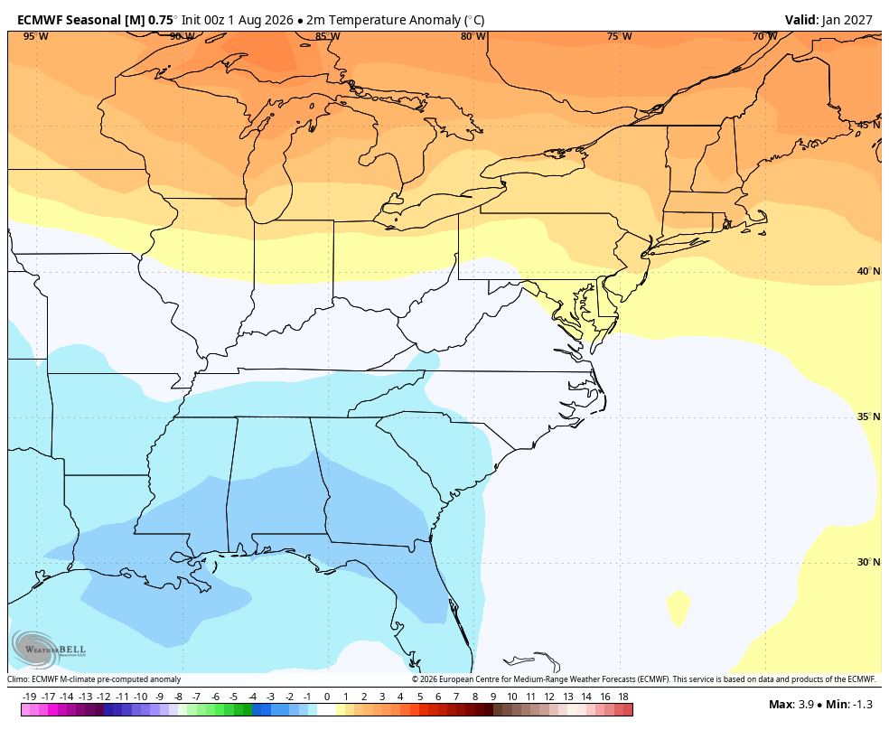
Jan and esp Feb look quite acceptable on the latest run. Beginning of winter is likely gonna suck so who cares about the 3 month maps. Best chance for a big East coast snowstorm will probably be mid Jan to mid Feb, but Dec is(subjectively) a modest improvement at h5 over the July run.
-
Global warming is obviously occurring?
-
.thumb.gif.f92b16c631a1d15d405ed77b33f0710d.gif)
Augdewst 2026: Summer's Last Stand
Torch Tiger replied to Prismshine Productions's topic in New England
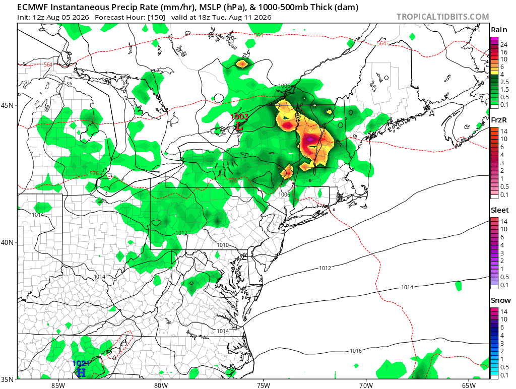
12z euro looks semi-interesting Tuesday for a few runs. Mcs look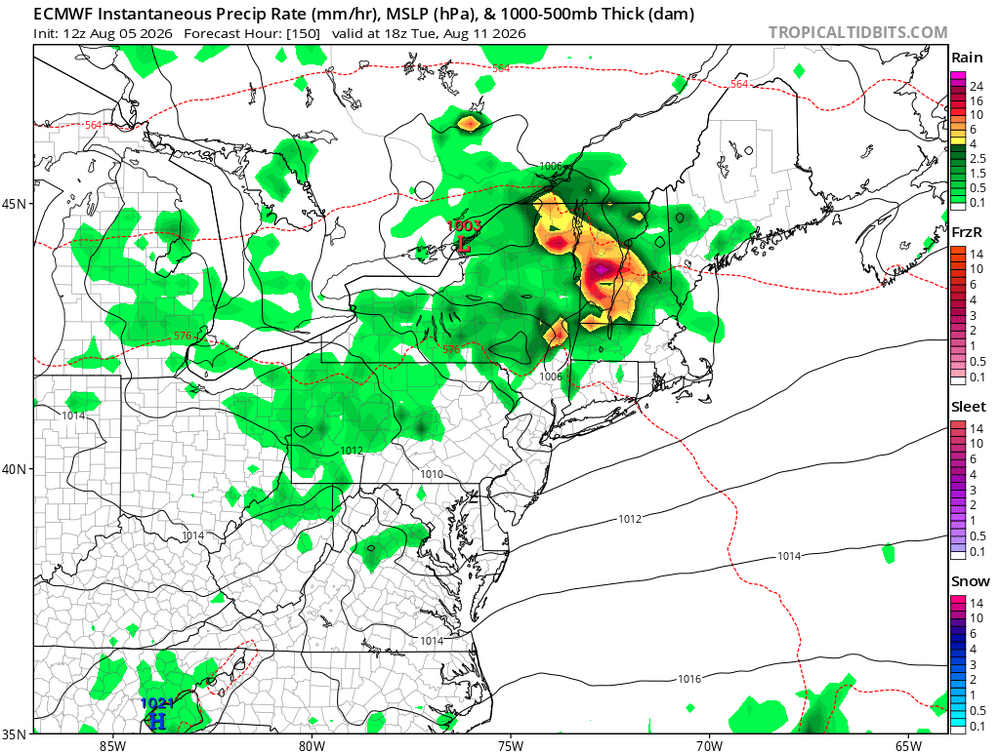
-

Winter 2026-2027 Seasonal Outlook
GaWx replied to WinstonSalemArlington's topic in Southeastern States
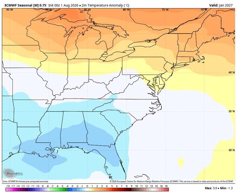
New Euro at 2m: looks good to me but I expect Dec to be mild. So, I’d take this in a heartbeat! Jan is slightly cooler: I like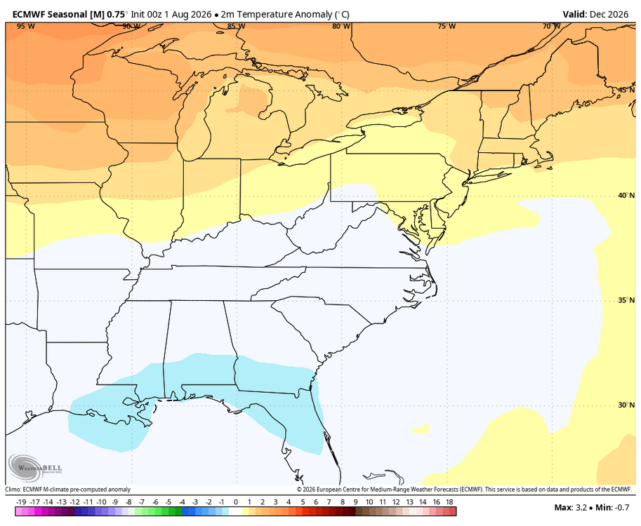
-
well that storm has moved over east central Balt Co and it is no joke... It is raining in sheets... rain gauge says it is averaging 3.47 inches per hour
-
2026-2027 Record-breaking El Nino
bluewave replied to Stormchaserchuck1's topic in Weather Forecasting and Discussion
That post was about the 1997-1998 winter which followed 1961-1990 climatology. This winter will be using 1991-2020 normals. Rankings will be based on the 1895 to 2027 full period of record. -

Augdewst 2026: Summer's Last Stand
RUNNAWAYICEBERG replied to Prismshine Productions's topic in New England
This is your brain on beer… -
1.58 for the day and 2.60 for August already. Ready for the drought to come back!
-
e44 it is.
-
.23 today after the latest round. Truly the dog day's of summer.
-

2026-2027 Record-breaking El Nino
mitchnick replied to Stormchaserchuck1's topic in Weather Forecasting and Discussion
Some Euro January temp maps off WxBell courtesy MA forum. Top map is from the July forecast and bottom is August's.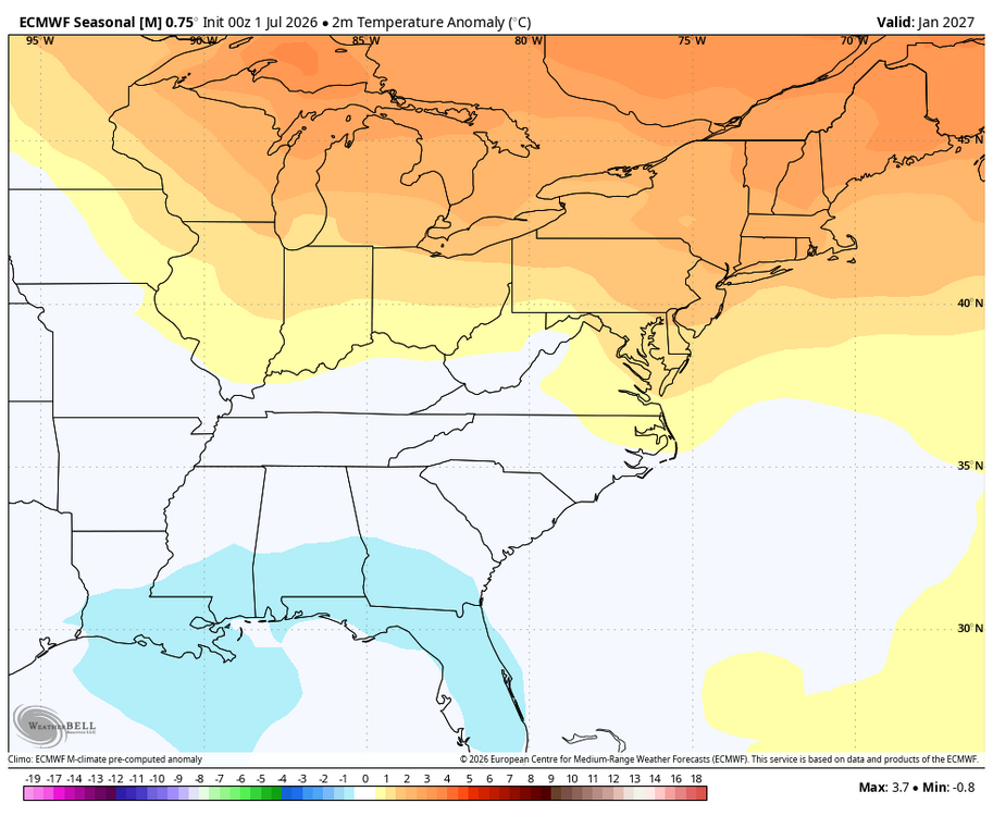
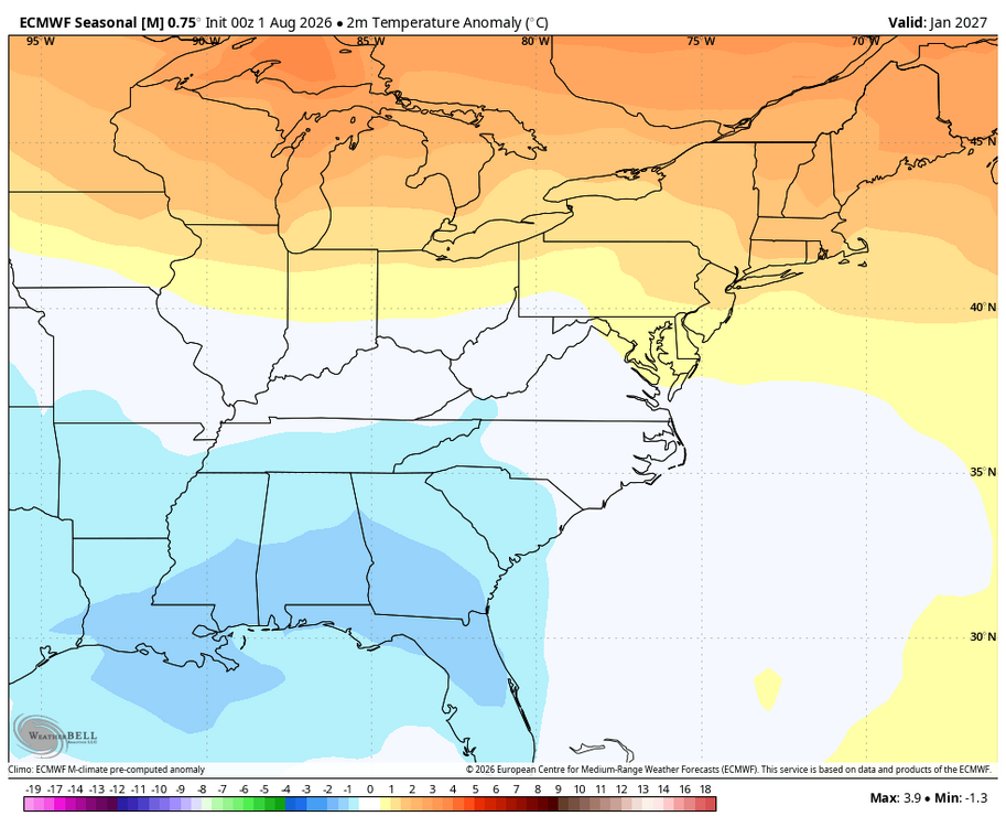
-

E PA/NJ/DE Summer 2026 Obs/Discussion
MGorse replied to PhiEaglesfan712's topic in Philadelphia Region
All the best to you out in Denver! -

E PA/NJ/DE Summer 2026 Obs/Discussion
Hurricane Agnes replied to PhiEaglesfan712's topic in Philadelphia Region
Getting round 3 with >1"/hr and am at the 1.00" mark for the day so far. Temp 77/dp 76. -
So we are going to base this Winter on the 91-20 average? I can tell you right now that will be warm. I would rather do the most recent 30-years.
-
The storm in west Baltimore county is raking someone with rain.