All Activity
- Past hour
-

2026-2027 Strong/Super El Nino
bluewave replied to Stormchaserchuck1's topic in Weather Forecasting and Discussion
The last two El Niños going over +2.0 had these La Niña-like tendencies overlapping with the El Niño. The SSTs have been so warm through the Indian Ocean into the Western Pacific, that the MJO 4-7 forcing has been very active. In the old days when cooler SSTs prevailed there, the MJO was quiet in these more Niña-like phases. Obviously, December 2015 was the most extreme example of this. That historic month actually had the strong MJO 5 combine with the El Niño to produce the record +13 month in the Northeast. None of the long range models had this in the forecast for December. The unusual Niña-like MJO 4-6 in January 2024 with a Southeast ridge wasn’t anticipated by the seasonal models. They had the classic El Niño stock composite and a deep trough in the Mid-Atlantic and Southeast. The record heat this week with the forcing coming out of the 4 region wasn’t well forecast back at the start of May. https://phys.org/news/2021-04-distinctive-mjo-super-el-nino.html A research group, led by Dr. Wenjun Zhang from the Nanjing University of Information Science and Technology analyzed MJO activity of the super El Niño event during the Northern Hemisphere winter of 2015/16. Observations show that the western Pacific MJO activity was strongly suppressed during the peak phase of the 1982/83 and 1997/98 super El Niño events. However, during the crest of the 2015/16 super El Niño event, western Pacific MJO-related convection was enhanced. "It is apparent that the enhanced western Pacific MJO is mainly related to its sea surface temperature (SST) anomaly distribution and the associated background thermodynamic conditions." said Dr. Zhang. His team's complete research and data are published in Advances in Atmospheric Sciences. When compared to the previous super El Niño events, the warm SST anomaly, or change from average, of the 2015/16 El Niño was located more westward than during the other two extreme seasons. Additionally, no significant cold SST anomaly was detected in the western Pacific. Accordingly, the moisture and air temperature tended to increase in the central-western Pacific during the winter of 2015/16 unlike the previous super El Niño events. This research highlights that climatologists should consider the SST anomaly distribution of super El Niño events for future MJO activity studies. https://journals.ametsoc.org/view/journals/clim/38/23/JCLI-D-24-0689.1.xml Easterly anomalies occurred in the equatorial central Pacific “unexpectedly” in January 2024, when an El Niño was at its peak. The cause of this “abnormal” zonal wind condition is investigated through the decomposition of multi-time-scale signals. The result indicates that the easterly anomalies arose from the combined effects of the Madden–Julian oscillation (MJO), the interdecadal variability–global warming trend (IDGT) signal and the “pure” interannual signal. It is found that a slowly moving active-phase MJO appeared over the Indo-Pacific warm pool during January 2024, and, as a result, there is a net positive precipitation anomaly over the warm pool, leading to easterly anomalies in the western-central equatorial Pacific. The IDGT signal since 1979 exhibits an enhanced zonal sea surface temperature (SST) gradient across the equatorial Pacific, which strengthens the trade wind at the equator. The summation of the MJO and IDGT signals surpassed the El Niño–induced westerly anomaly, leading to an unexpected equatorial easterly anomaly in January 2024. An assessment of observational data since 1979 shows a 10% chance of the occurrence of such an “uncoupling” during El Niño, during which the MJO and/or IDGT modes did play a role. https://pubmed.ncbi.nlm.nih.gov/31776488/ Here we show that rapid warming over the tropical oceans during 1981-2018 has warped the MJO life cycle, with its residence time decreasing over the Indian Ocean by 3-4 days, and increasing over the Indo-Pacific Maritime Continent by 5-6 days. We find that these changes in the MJO life cycle are associated with a twofold expansion of the Indo-Pacific warm pool, the largest expanse of the warmest ocean temperatures on Earth. The warm pool has been expanding on average by 2.3 × 10⁵ km2 (the size of Washington State) per year during 1900-2018 and at an accelerated average rate of 4 × 10⁵ km2 (the size of California) per year during 1981-2018. The changes in the Indo-Pacific warm pool and the MJO are related to increased rainfall over southeast Asia, northern Australia, Southwest Africa and the Amazon, and drying over the west coast of the United States and Ecuador. -
I have to work at the commencement for Coppin State on Friday. I will need my poncho.
-
lmao even
-
High 89.0, low 58.0. Warm/hot but not at record levels (92 in 1996). Currently 62.1/57.5 at 7:30 am with partly cloudy skies.
-
The CAMs were wrong about everything getting stuck in Missouri and nothing getting up here. There were no strong storms around here, so in that regard the weekend was a dud. However, another round of solid rain dropped 0.64" in my yard overnight. Four decent rounds of rain through the weekend added up to 1.86". The rest of the month is looking drier and fairly boring again.
-
Looks like we get storms here today if the NAM is right.. plus with what we had last week and what coming this weekend all of us should be good
-
Front might be a bit too fast.
-
HRRR literally has no storms tomorrow . Will be tough to come out of this 5 day heater with no rain
-
I did not . 40’s and rain thru weekend?
-
Yeah, best weather this weekend is north and east. Seems like Saturday and part of Sunday maybe we can salvage down here.
-
GWDLT Saturday?
-
Did you look at 6z?
-

Central PA Spring 2026 Discussion/Obs Thread
mahantango#1 replied to Voyager's topic in Upstate New York/Pennsylvania
We'll take it one day at a time. - Today
-

Central PA Spring 2026 Discussion/Obs Thread
pawatch replied to Voyager's topic in Upstate New York/Pennsylvania
Montourville recorded a high of 94 yesterday. “Airport NWS” Didn't break a record…record 95 degrees set 1962. Garden view where I live, we had 95-96 depending what thermometers I go off of. We also had a lot of thunder and lightning in the area from 10:30 pm to 1:30 pm. One heck of a lightning storm, but very little rain. rainfall total for me .02” someone got hit? -
That’s not the op
-
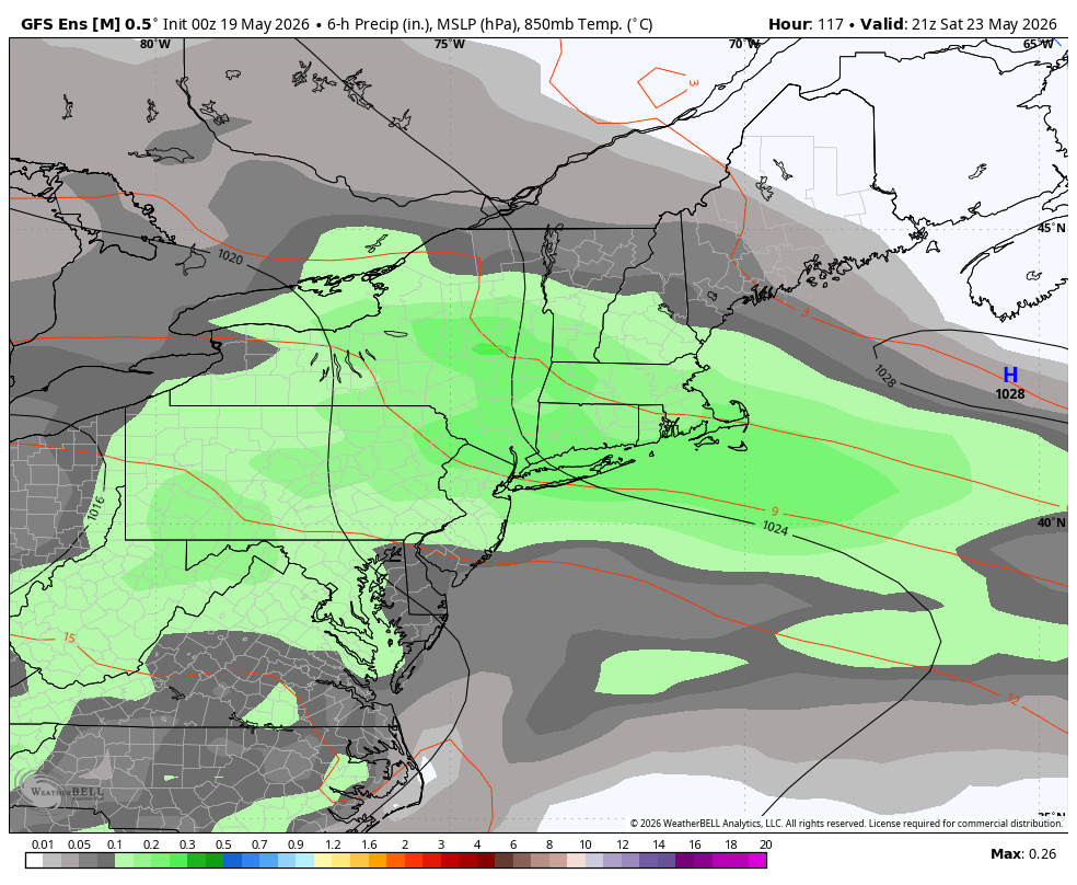
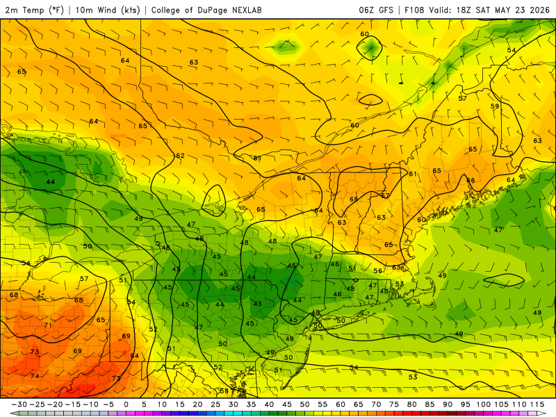
It is? Here's the GFS.

-

2026-2027 Strong/Super El Nino
40/70 Benchmark replied to Stormchaserchuck1's topic in Weather Forecasting and Discussion
I think keying in on major signals when developing an analog composite does have some value. -

Central PA Spring 2026 Discussion/Obs Thread
Voyager replied to Voyager's topic in Upstate New York/Pennsylvania
Indeed... But...it's hard to get excited about the summer like weather when the forecast high for Saturday drops all the way down to 58 with mid 40's lows again. -
2026-2027 Strong/Super El Nino
40/70 Benchmark replied to Stormchaserchuck1's topic in Weather Forecasting and Discussion
I def. wouldn't be as worried about it where you are....more wiggle room. -

E PA/NJ/DE Spring 2026 Obs/Discussion
Hurricane Agnes replied to PhiEaglesfan712's topic in Philadelphia Region
After a 67 low yesterday, I hit 95 for a high just before 3 pm. Another scorcher today with my low so far a little with my low of 71 so far about 4 degrees warmer than yesterday. Currently sunny and 72 with dp 69. -

Central PA Spring 2026 Discussion/Obs Thread
Mount Joy Snowman replied to Voyager's topic in Upstate New York/Pennsylvania
68 at the house, 64 through the rurals. Looks like MDT topped out at 93 yesterday. Can we go record chasing today? Quite the unsettled period coming up it appears. -
Alll the AI’s and GFS suppress it all south . Euro is still showery . We’ll see
-
Is the weekend doneski bunky you think?
-
LWX doesn't seem to be buying it
-
It’s now Euro vs world for the weekend