All Activity
- Past hour
-
Car says 83 lol
-
 I always remember Jul 95…mid level clouds until 9-10am and then it was off to the races. But yeah, clouds are collapsing pretty well on IR.
 -
 0.32". Nice surprise Sent from my SM-S921U using Tapatalk
 -

Central PA Summer 2026 Discussion/Obs Thread
mahantango#1 replied to Voyager's topic in Upstate New York/Pennsylvania
Thats a good solid number, too bad others didn't make out so good. Last week I got most of my rain for the month. -
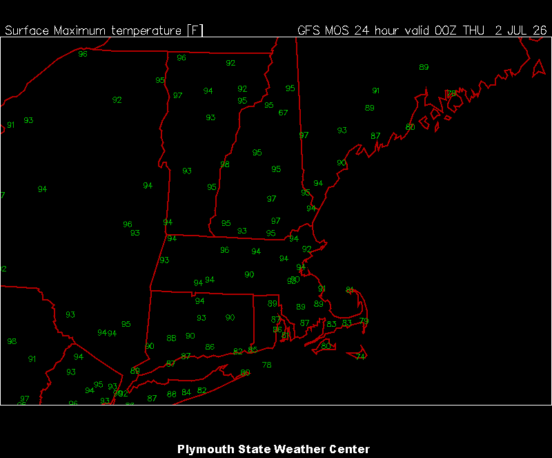
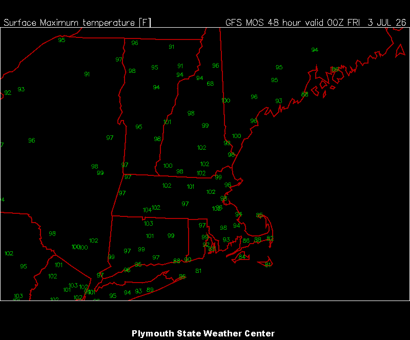
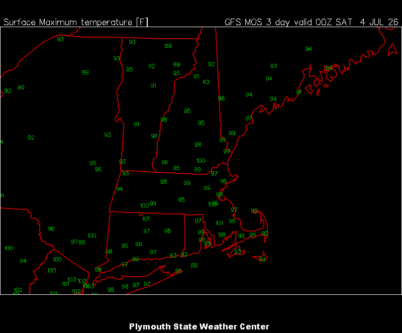
The 3 hot days are in the plym mav mos plotting window now.
-
 Clouds seem to dissipating fairly quickly. Might be a bunch of cirrus through late morning.
 -
94/75 for DTW yesterday. So far overnight the low is 79 at DTW and 81 at DET.
-
Nah it’s just why nobody cares about convection around here except for a few poor souls.
-
Loud storm
-

Central PA Summer 2026 Discussion/Obs Thread
Voyager replied to Voyager's topic in Upstate New York/Pennsylvania
My total for June was 4.35". -
That's good stuff but way overcomplicates it. The simple fact it that the sun doesn't really heat the air- it heats the ground which then transfers the heat to the air by radiation, and it was probably determined that 2 meters was a height where there is significantly less direct influence from retention of heat/ radiation of heat from ground. And again, that height is approximately human head level.
-
 Scott mad. Highest measured total was 21" at Darkhorse Lake MT elevation 8700 ft.
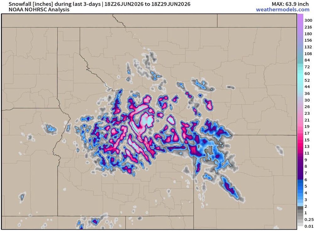
-
Mista Steinolina Mista Dave Steinolina You thought you could precipitate you thought you could fool me
-
 I'll be headed to Mattapoisett tomorrow night....hoping the water will mitigate the temp. Any wind direction that includes that does not includes a north component is coming from the water, so that'll help. Running (ha) a race there on Saturday, too. Meanwhile, it was really cool at Pit2 yesterday, at least in the later afternoon/evening. Temp was in the 70's as I drove from Waterville toward Gardner and it was all of 72* when I pulled into the house here.
 -
Picked up 0.56”. Nice drink before the heat
-
 I woke up around 3:00 to thunder and was psyched. Looked at radar and went back to bed. Thank you Mr. Steiner. When you hit, you hit hard
 -
Max here yesterday was 90.1 at 1:09 pm. 68⁰ now with a noisy thunderstorm in progress. 0.40" in the guage so far. Nice!
-
Quick heavy burst-hoping we get more Lots of lightning to north
-
Central PA Summer 2026 Discussion/Obs Thread
mahantango#1 replied to Voyager's topic in Upstate New York/Pennsylvania
My June total rain fall was 2.95 Eric Finkenbinder Ssodtpeorn9201th15agtm456l1iu194u6u50tfu73811fi9m3th867i28t9 · While extreme heat takes headlines this week, I'm increasingly concerned about our growing rain deficit. Storm chances return this weekend, but storm coverage appears limited. -
Solid storm out here
-
Central PA Summer 2026 Discussion/Obs Thread
mahantango#1 replied to Voyager's topic in Upstate New York/Pennsylvania
Extreme Heat Warning URGENT - WEATHER MESSAGE National Weather Service State College PA 211 AM EDT Wed Jul 1 2026 PAZ019-026>028-036-045-046-049>053-056>059-063>066-012100- /O.CON.KCTP.XH.W.0001.260701T1600Z-260704T0000Z/ /O.CON.KCTP.HT.Y.0003.260704T0000Z-260705T0000Z/ Southern Centre-Huntingdon-Mifflin-Juniata-Franklin-Southern Clinton-Southern Lycoming-Union-Snyder-Montour-Northumberland- Columbia-Perry-Dauphin-Schuylkill-Lebanon-Cumberland-Adams-York- Lancaster- Including the cities of Newport, Mount Union, Selinsgrove, Pottsville, Lewisburg, Carlisle, Lewistown, Mifflintown, Chambersburg, Gettysburg, York, Shamokin, Berwick, Lebanon, Lancaster, Harrisburg, State College, Hershey, Lock Haven, Sunbury, Huntingdon, Williamsport, Danville, and Bloomsburg 211 AM EDT Wed Jul 1 2026 ...EXTREME HEAT WARNING REMAINS IN EFFECT FROM NOON TODAY TO 8 PM EDT FRIDAY... ...HEAT ADVISORY REMAINS IN EFFECT FROM 8 PM FRIDAY TO 8 PM EDT SATURDAY... * WHAT...For the Extreme Heat Warning, dangerously hot conditions with heat index values up to 110 expected. For the Heat Advisory, heat index values up to 104 expected. * WHERE...A portion of central Pennsylvania. * WHEN...For the Extreme Heat Warning, from noon today to 8 PM EDT Friday. For the Heat Advisory, from 8 PM Friday to 8 PM EDT Saturday. * IMPACTS...Heat related illnesses increase significantly during extreme heat and high humidity events. * ADDITIONAL DETAILS...High temperatures will exceed 100 degrees in many places today, Thursday and Friday with even higher heat index values expected. Temperatures will be a few degrees lower on Saturday, but heat risks will continue. PRECAUTIONARY/PREPAREDNESS ACTIONS... Know the signs and symptoms of heat exhaustion and heat stroke. Review heat safety and preparedness information at weather.gov/safety/heat. To reduce risk during outdoor work, the Occupational Safety and Health Administration recommends scheduling frequent rest breaks in shaded or air conditioned environments. Power outages are possible during periods of extended heat as the extra demand for electricity can tax the power grid. Be prepared for a possible power outage. -
 Solid inch so far
 - Today
-
East of the river stein baby
-
WxWiz AM PT?

-
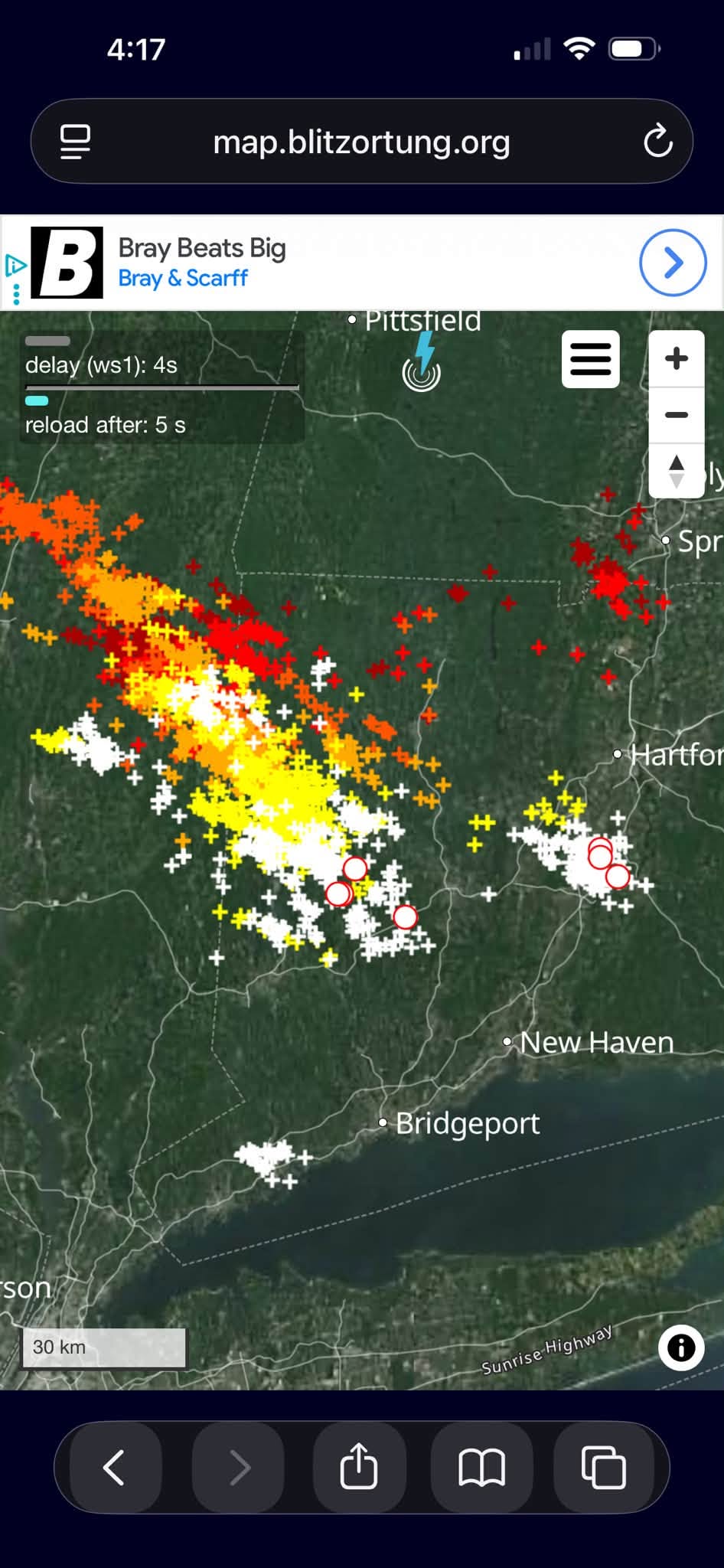
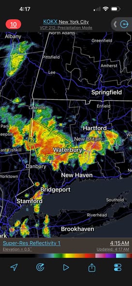
Western conn is just getting hammered right now from that complex heading south. Why do they keep stealing all of the fun out towards the western frontier? It’s not fair, damnit!