All Activity
- Past hour
-

2026-2027 Record-breaking El Nino
40/70 Benchmark replied to Stormchaserchuck1's topic in Weather Forecasting and Discussion
When in doubt regarding the impact of CC, expect generally warmer and greater volatility. -

2026-2027 Record-breaking El Nino
Terpeast replied to Stormchaserchuck1's topic in Weather Forecasting and Discussion
Thats also my guess. Weaker goa/aleutian low, and I also wonder if it will be further west allowing for more -epo. But who really knows. I would expect the unexpected. -

2026 Atlantic Hurricane Season
WxWatcher007 replied to Stormchaserchuck1's topic in Tropical Headquarters
Thought about a thread too but will keep discussion here. I think a mod could always move these posts to a thread for posterity if Fay pulls off something crazy. It's a very narrow window but as y'all stated it's in one of where it can take off. That'd obviously be fantastic for my peak season forecast. Tropical Storm Fay Discussion Number 5 NWS National Hurricane Center Miami FL AL062026 300 PM GMT Sun Sep 20 2026 Deep convection continues to build near the center of Fay over the last several hours. The current objective intensity estimates from UW-CIMSS are in the range of 39-52 kt, and the most recent TAFB Dvorak fix was a T3.0/45 kt. In addition, there was an ASCAT pass that showed a peak wind vector of 43 kt. Given the uncertainties due to undersampling, the initial intensity for the storm has been raised to 50 kt. The cyclone continues to remain very compact with its tropical-storm-force winds estimated to extend out to about 40 n mi. Both a relatively moist environment and positive interactions with an approaching mid- to upper-level trough should allow Fay to further intensify for the next 12 to 24 hours. After the trough lifts on Monday, the increase in wind shear and dry air should lead to a gradual weakening of the cyclone. The current NHC forecast calls for Fay to become a post-tropical remnant low by Tuesday and then dissipate by the end of the week. The official intensity forecast is a little higher than the model guidance in the short term to account for the storm's structure being more improved and the expected baroclinic support from the trough. This small system could approach hurricane strength later today or tonight. Fay is slowly moving off to the northeast, with the initial motion estimated around 010/5 kt. This general motion should continue for the rest of the day. However, a low- to mid-level ridge is expected to build to the north of the storm by Monday, which will cause Fay to turn southwestward and gradually accelerate in that direction over the course of the forecast period. The current NHC track forecast is similiar to the previous track forecast with a few minor adjustments and remains in good agreement with HCCA and GDMI. FORECAST POSITIONS AND MAX WINDS INIT 20/1500Z 34.1N 33.0W 50 KT 60 MPH 12H 21/0000Z 34.3N 32.6W 60 KT 70 MPH 24H 21/1200Z 33.9N 32.4W 50 KT 60 MPH 36H 22/0000Z 32.9N 32.9W 45 KT 50 MPH 48H 22/1200Z 31.7N 34.2W 35 KT 40 MPH 60H 23/0000Z 30.6N 35.9W 30 KT 35 MPH...POST-TROP/REMNT LOW 72H 23/1200Z 29.8N 37.7W 25 KT 30 MPH...POST-TROP/REMNT LOW 96H 24/1200Z 28.8N 41.1W 25 KT 30 MPH...POST-TROP/REMNT LOW 120H 25/1200Z...DISSIPATED $$ Forecaster Katz/Pasch -
it's not going to be all winter, it's going to be the majority of the winter.
-
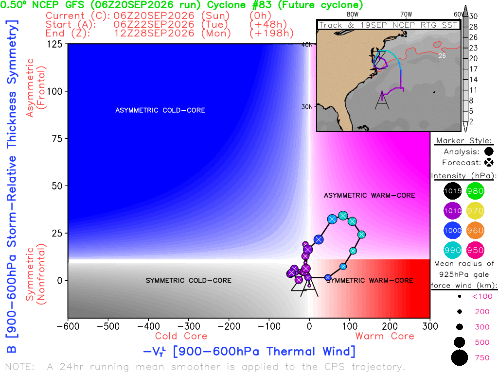
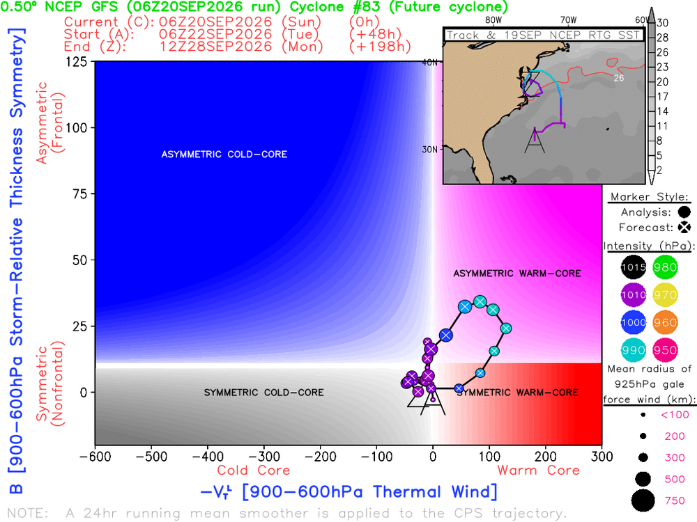
We now have Fay, which breaks our tropical drought, albeit in a very weird part of the basin. Peak Season Forecast (Aug 20-Oct 20) Named Storms: 5 (3) Hurricanes: 3 (0) Major Hurricanes: 1 (0) Dolly, Edouard, Fay Fay is actually doing more than holding its own after struggling yesterday, and the NHC has taken note, predicting it gets to 50kt (60mph). This is a good looking structure, and this one could be an overperformer. Obviously I have a rooting interest. But I want to take a few minutes to talk about some possible east coast action in the coming days. There's been a signal for a few days now for a coastal storm development pattern over then next two weeks. A signal has emerged for an area of low pressure to form off the east coast around midweek. Across guidance you see a similar theme--our low starts out a sprawling mess, but eventually consolidates into a pretty decent coastal storm. This is the 06z Euro And the surface result Now, it's important to note, I'm not talking about anything purely tropical here. This is more baroclinic than anything. But given the location of development, there may be some tropical influence making this a subtropical or hybrid low, and these can be very impactful storms. The GFS and AI guidance so far today have been more bullish on possible subtropical development. Regardless, this is the kind of low that could cause some legitimate issues, first with coastal flooding. Everything suggests that if something forms close enough to the coast it's going to meander and bring persistent onshore flow. That could lead to significant coastal flooding. Second, rainfall. Depending on where this tracks, areas could see significant rainfall. Finally, this looks to be a windy event, especially at the coast, due to the possible intensity of the storm and a pressure gradient. 06z GFS 06z Euro As I mentioned, the AI guidance has been even more bullish, at least for now, in developing a potent coastal. But they've favored areas northeast. Still, the onshore flow could cause issues up and down the coast. Bottom line is we do have something to track, for now at least. Intensity and track are still TBD, but there's a growing signal for some type of significant coastal storm in the coming days.
-
2026-2027 Record-breaking El Nino
40/70 Benchmark replied to Stormchaserchuck1's topic in Weather Forecasting and Discussion
No one mentions this part... -
 https://getbelvion.com/# Sildenafil 100mg price
 -
buy Viagra online: GetBelvion - Cheap generic Viagra
-
Nam and RRFS have a narrow swath of heavy rain later
-

2026-2027 Record-breaking El Nino
GaWx replied to Stormchaserchuck1's topic in Weather Forecasting and Discussion
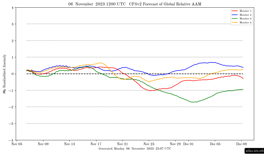
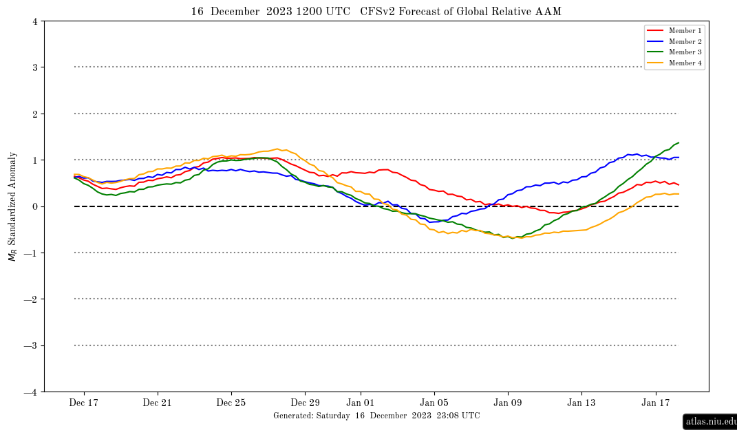
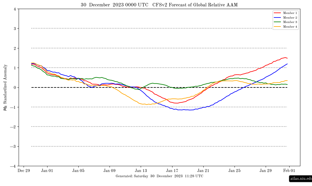
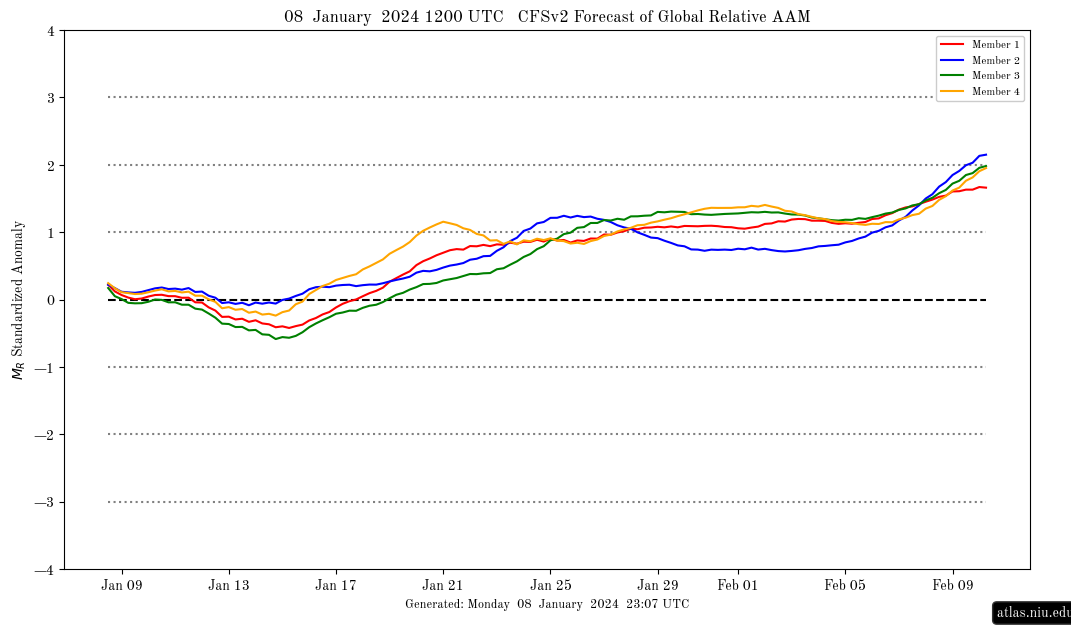
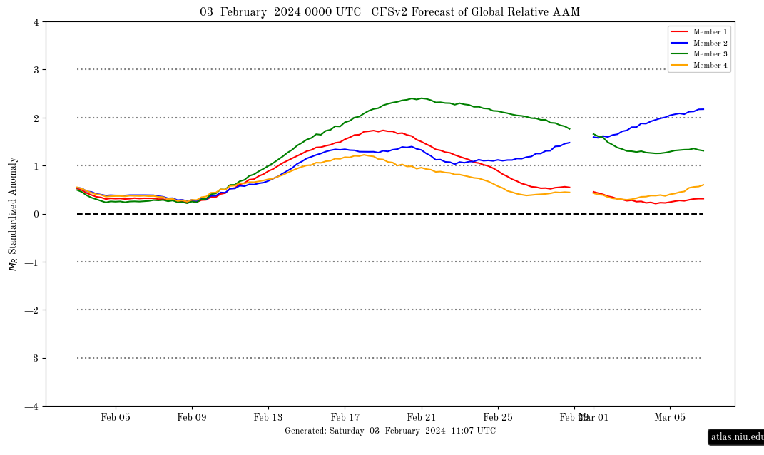
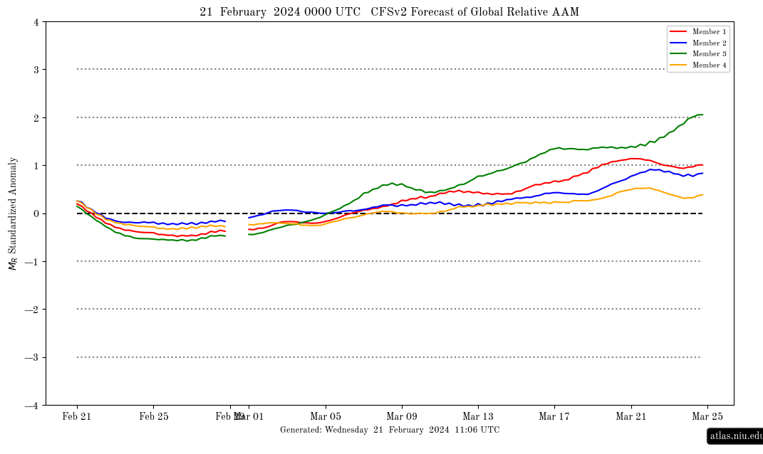
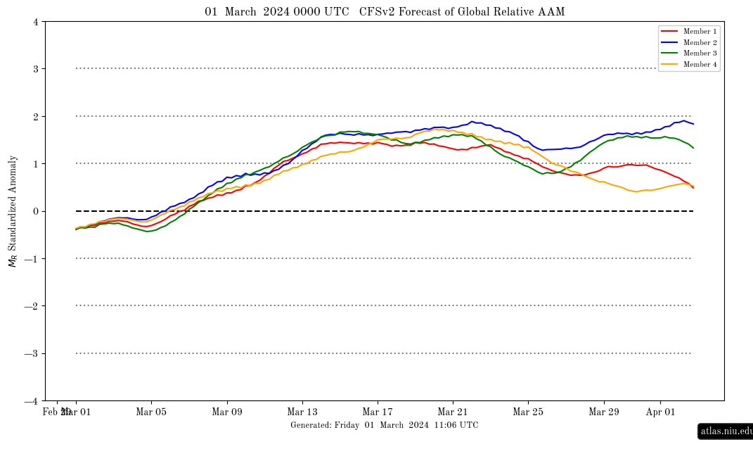
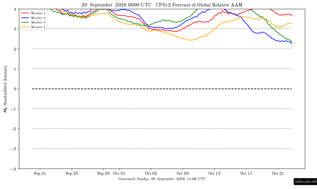
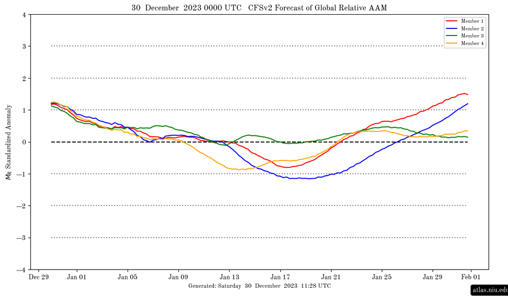
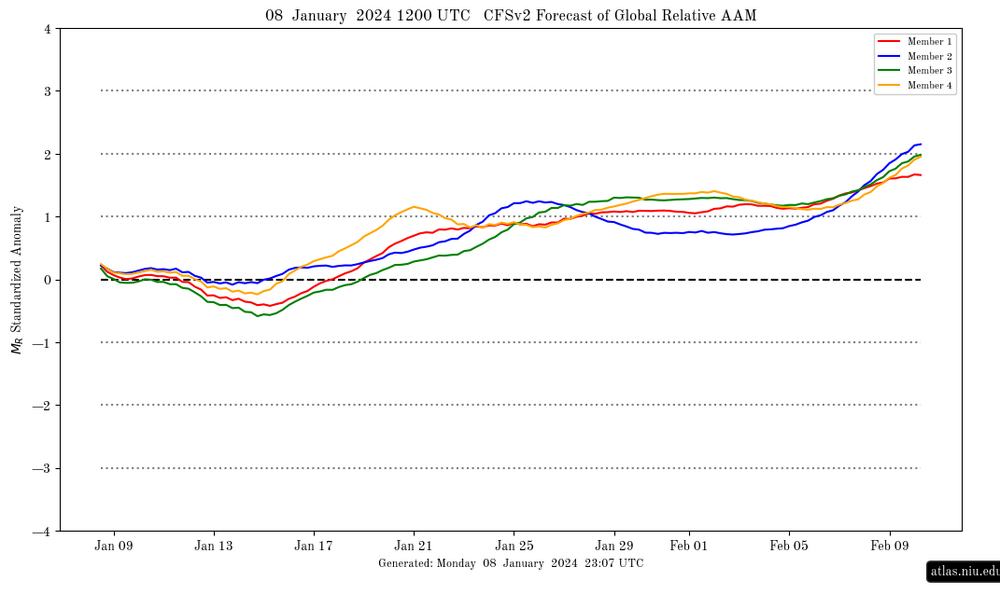
Further to my global relative AAM post above showing it >+4 since yesterday and to show the huge contrast to the prior El Nino, here are some of the graphs I saved from 2023-4, which all show a much lower amplitude (keep in mind that CFSv2 progs looking out especially past 2 weeks have been biased positive as comparing these graphs to each other clearly show): 11/6/23: +0.15 12/16/23: +0.7: 12/30/23: +1.15 (highest of any I saved from 2023-4) 1/8/24: +0.15 2/3/24: +0.5 2/21/24: +0.2 3/1/24: -0.35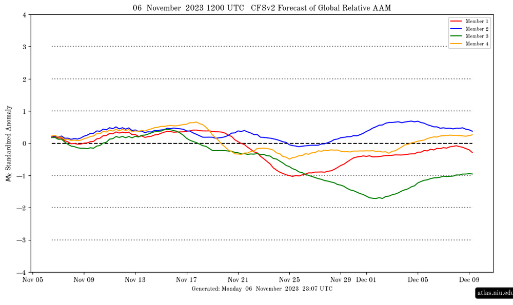

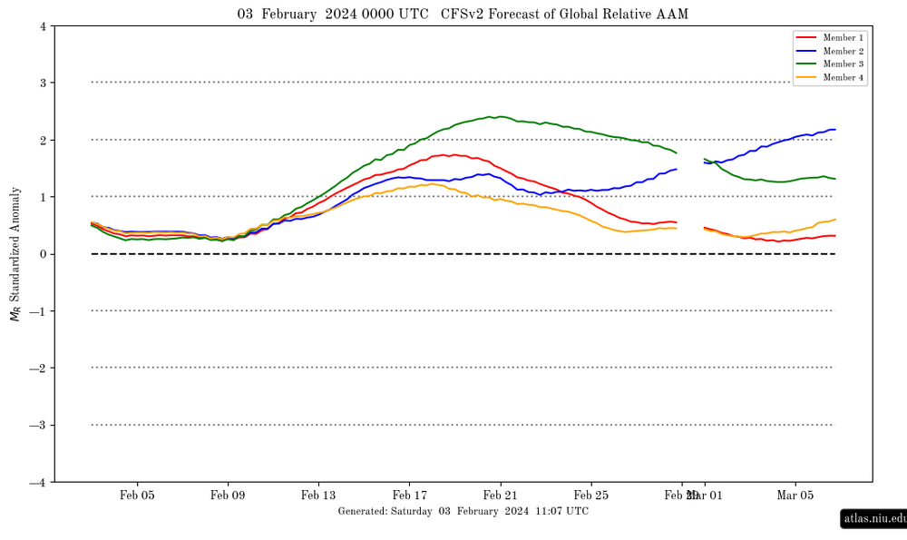
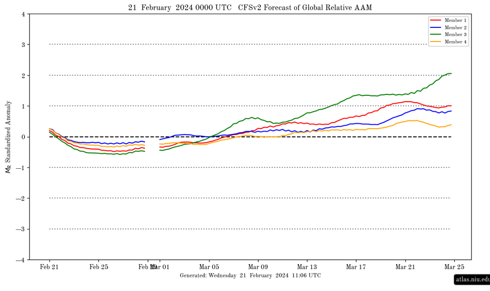
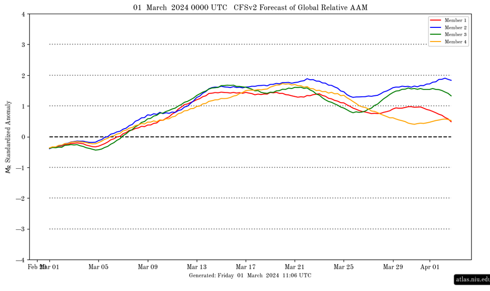
-
Could develop some subtropical characteristics.
-
We deserve to be buried this winter in snow. Make it a 70" winter.
-
3" in the gauge since Friday. Total of 4.5" for the last week.
-
Septorcher 2026 Discussion - Endless Summer
WxWatcher007 replied to Damage In Tolland's topic in New England
I've liked the signal for a while now. Just wish it tapped a little more into tropical influence. The runs today seem to be a little more potent with perhaps some subtropical/hybrid potential, but we're obviously still a ways out. AI ensembles look more bullish but you can see a little signal there across guidance. For the weenies among us, to be clear, I'm not saying we're going to get crushed by tropical lol. Just that the general pattern seems open for one of these coastals bearing hybrid characteristics. As @vortex95 notes, that's a bit unusual for this time of year along the east coast with "hybrid" season usually being in October, but given the overarching hostility in the Atlantic basin this year it's not surprising that the east coast right now could only support some kind of sprawling mess. -
how is a biggie going to happen with pac air all winter
-

Central PA Summer 2026 Discussion/Obs Thread
mahantango#1 replied to Voyager's topic in Upstate New York/Pennsylvania
.58 rain so far. - Today
-
A little over 4.5" since yesterday here. Up to 7.41" for Sep. Almost 7 inches more than Sep 2025 lol.
-

2026-2027 Record-breaking El Nino
bluewave replied to Stormchaserchuck1's topic in Weather Forecasting and Discussion
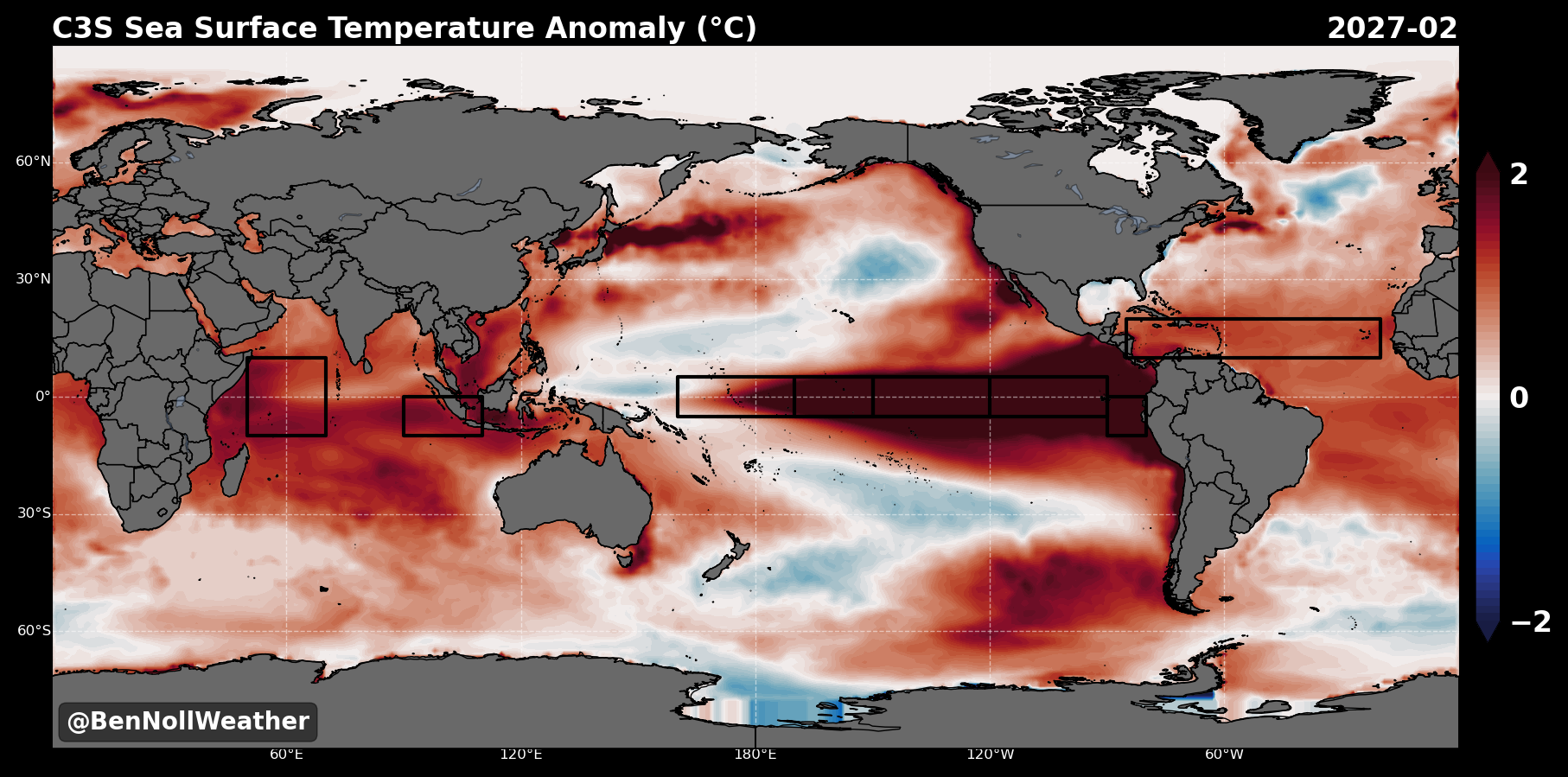
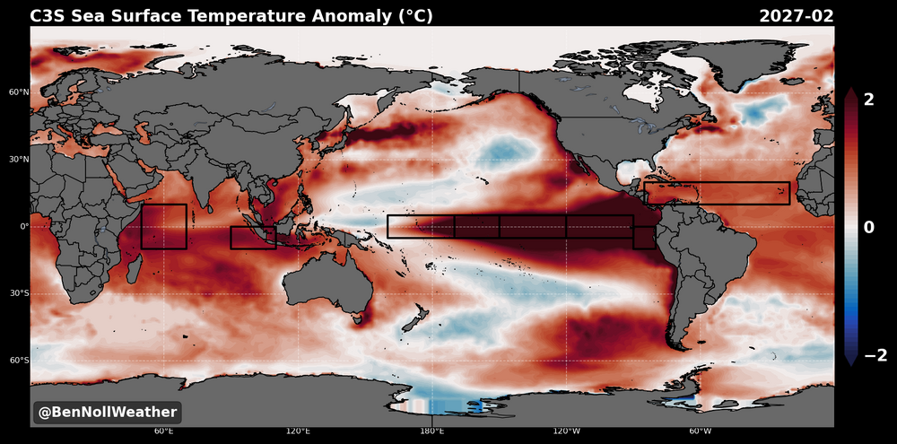
Even if the PDO goes neutral during the winter, relatively speaking it would be much lower than the +1.70 peak in March 2016 and +1.47 in February 1998. The main difference would be the much warmer West Pacific from Japan to south of the Aleutians. My guess is that this would promote more ridging from east of Japan to perhaps north of Hawaii. Could weaken the Aleutian low and also the low which typically resides near the Southeast US. This could also potentially shift the STJ location. Plus we have seen weaker troughs in general over the last decade and stronger ridges. Very wide spread between the global SST forecast for the February and 1998. So the PDO values might not fully capture the SST difference. Also note how much warmer the Atlantic is forecast to be.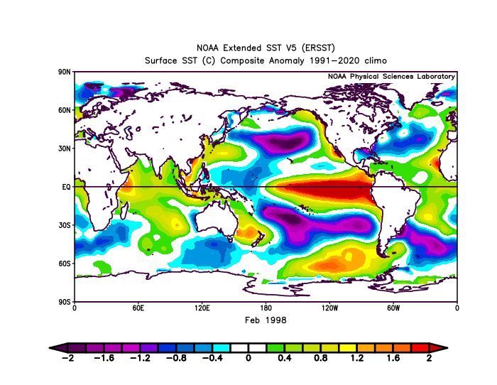
-
I grew up in the 80s, wrote my first program on a Commodore 64, got a BS/MS in computer science and work for one of the big tech companies. I am frankly ashamed at the current direction of tech and tech companies. Capitalism has sucked the soul out of it. I am glad I can retire/quit in a couple years. AI is yet another tool that can be utilized for good and bad. I don't like how we are shoving it down people's throats to use (Gemini auto installed on phones, Copilot invading every MS product etc). I am also seeing the bad effects of technology in the learning environment. My kids don't have textbooks. Everything is on the computer and they are glued to it. My kids aren't on social media and we place strict rules on the phones, and they have begrudgingly accepted. It doesn't help that 80% of their peers have what seems like unlimited access to phones and social media, so my kids sorta feel left out. Back to your question, I don't think you have to be worried about an end of the world / machines takeover the planet / Matrix / Terminator scenario. You should be concerned about information flow, propaganda, influence, and control/use of data. Everyone worried about the NSA monitoring you should really be worried about big business data mining you. Things like Flock etc. Not much you can do to prevent it, unless you want to build a remote bunker in the middle of nowhere and go off the grid. Sorry for the "get off my lawn" rant (I'm only 45!). I'm glad my kids are not super interested in tech and seem to like animals/agriculture/home improvement.
-
2026-2027 Record-breaking El Nino
GaWx replied to Stormchaserchuck1's topic in Weather Forecasting and Discussion
The global relative AAM remains in historic territory of +4+, which should last into tomorrow. This is probably its highest since Feb of 1998. For comparison, 2023-4 was no more than in the low +1 region on any of the graphs I saved with most of them <+0.5: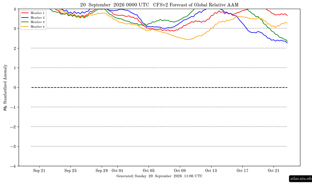
-
(002).thumb.png.6e3d9d46bca5fe41aab7a74871dd8af8.png)
Central PA Summer 2026 Discussion/Obs Thread
ChescoWx replied to Voyager's topic in Upstate New York/Pennsylvania
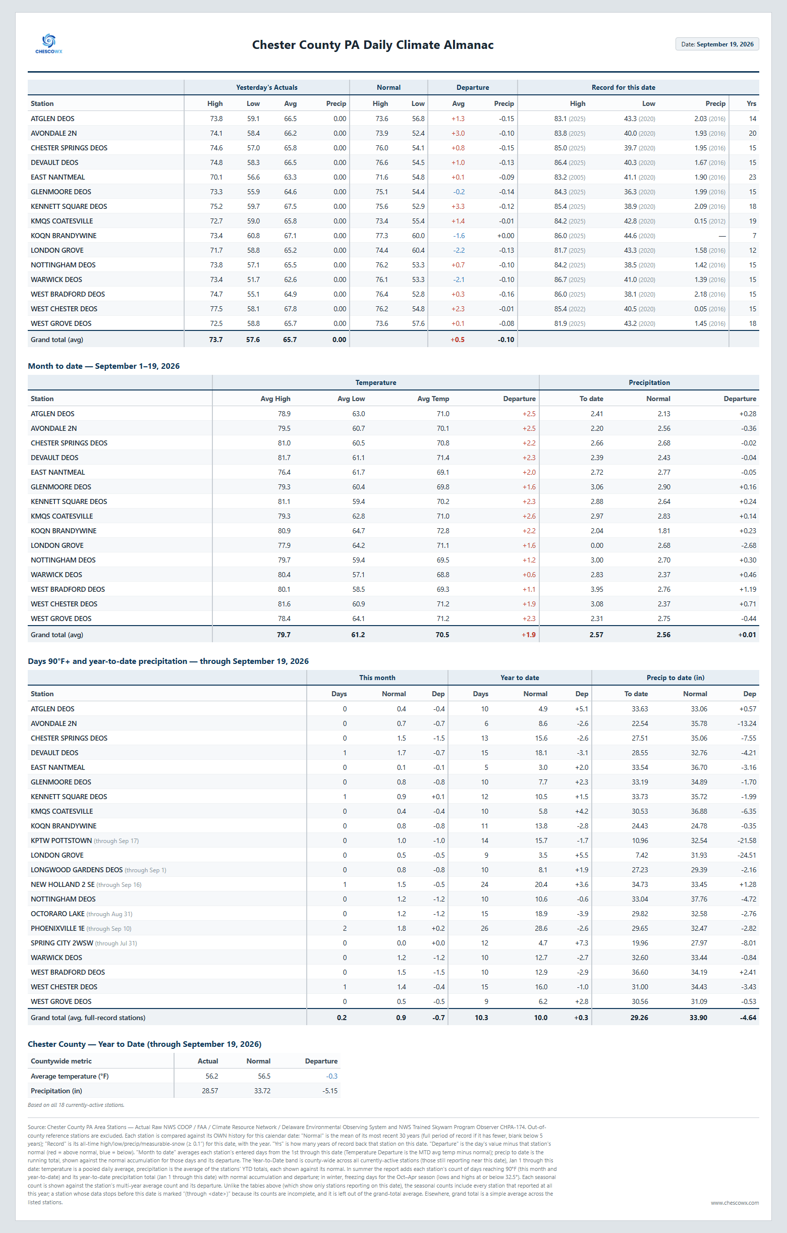
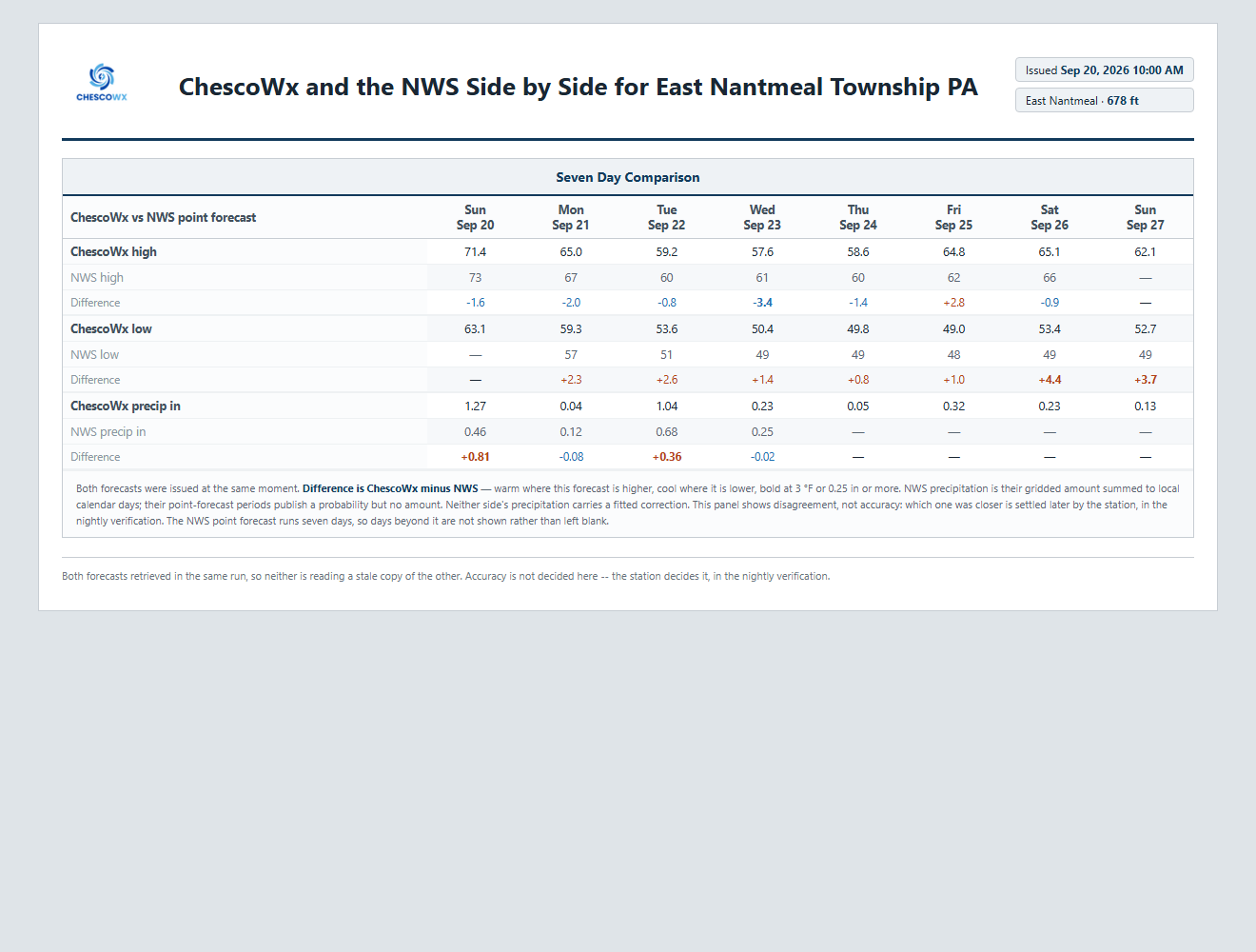
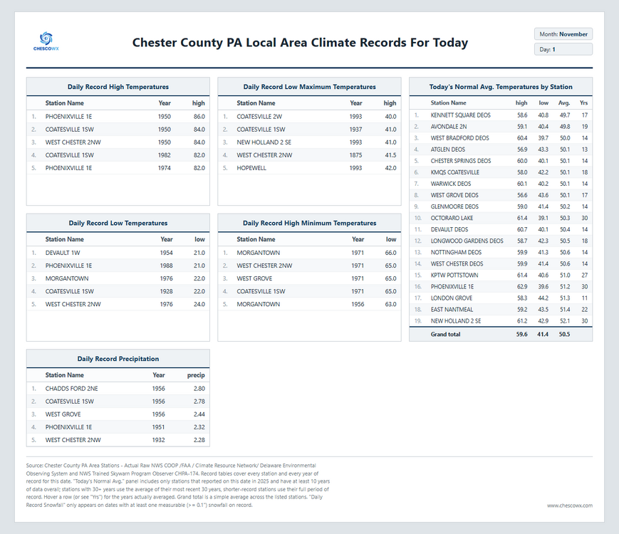
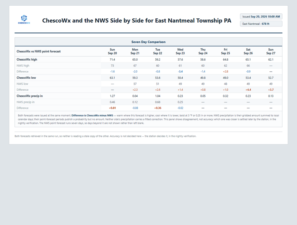
Not the best weather week on the way. Rain is at least possible every day through Friday. Best chances of rain will be today into tonight and again tomorrow night into Tuesday. There is the potential a coastal storm could develop from Wednesday into Thursday which could increase the rain threat but at this point plenty of uncertainty on when and where that storm will track. Either way well below normal temperatures on the way with highs from Tuesday through Thursday according to the ChescoWx model not escaping the 50's with lows in the 40's.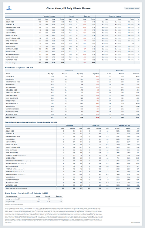
-
E PA/NJ/DE Autumn 2026 Obs/Discussion
ChescoWx replied to PhiEaglesfan712's topic in Philadelphia Region
Not the best weather week on the way. Rain is at least possible every day through Friday. Best chances of rain will be today into tonight and again tomorrow night into Tuesday. There is the potential a coastal storm could develop from Wednesday into Thursday which could increase the rain threat but at this point plenty of uncertainty on when and where that storm will track. Either way well below normal temperatures on the way with highs from Tuesday through Thursday according to the ChescoWx model not escaping the 50's with lows in the 40's.
-

2026-2027 Record-breaking El Nino
LibertyBell replied to Stormchaserchuck1's topic in Weather Forecasting and Discussion
There is very little warming of the days during the summer it's mostly a night time thing. I ran my heat after the middle of August this summer YUCK! I can't stand strong El ninos. Summers of 1991 and 2002 were MUCH better! 1983 will be great match for next summer too- endless summer heat April through September! We had 9 90 plus days in September alone! I'm going to love that big heat next summer and no rain, 40 90 degree days and 4 100 degree days in NYC and less than 6 inches of rain for the entire summer and a colder and snowier winter to follow than this one too. La ninas after El nino are the best for all seasons! -

2026-2027 Record-breaking El Nino
Typhoon Tip replied to Stormchaserchuck1's topic in Weather Forecasting and Discussion
you didn't ask for this opinion but personally believe every teleconnector there is should be analyzed and reanalyzed for relative correlation. RNAO, RAO, RPNA, RWPO, REPO ... RPDO etc The implications of a -RPDO with a +RONI is then headachy different than the non-relativistic tandem - -
Cheap generic Viagra online: Belvion - Viagra Tablet price