All Activity
- Past hour
-
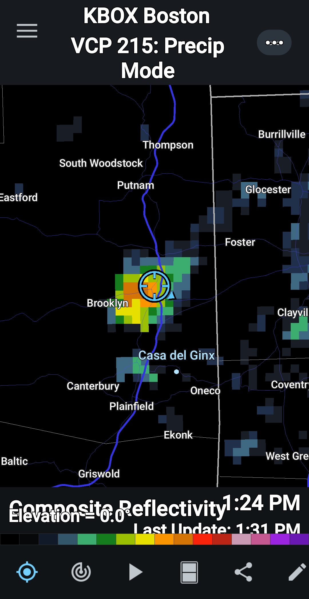
0.31" in that cell that passed by, 0.83" for the month so far.
-
Good, not home but my lawn needs it!
-
 locally the June heatwave was the big event of the summer-3 days of 98 or 99 which is impressive for here as we don't even get that many 90 degree days
 -

2025-2026 ENSO
40/70 Benchmark replied to 40/70 Benchmark's topic in Weather Forecasting and Discussion
I don't see why it matters unless someone is unconvinced of CC. We all understand that the world has warmed....but we measured based on current climo. -
 I immediately break out in hives when the thermometer hits exactly 32.222 degrees Celsius.
 -
 I had 3 days in a row here with two 88's and an 89. I think New Brunswick has 3 90s as well, but the hot spot Newark has 8 like Warlock. 90 is a fancy # we like to use, but like it matters being 88 or 90. No one on earth can tell the difference.
 -
2025-2026 ENSO
40/70 Benchmark replied to 40/70 Benchmark's topic in Weather Forecasting and Discussion
I don't care about the rankings. Most weather circles use departures based on current climo. -
2025-2026 ENSO
40/70 Benchmark replied to 40/70 Benchmark's topic in Weather Forecasting and Discussion
(Long winded) Mic drop- -
 Yeah 93 was the highest I got during that heat wave. It was impressive to be 90+ for 6 days in a row, but it was far from extreme heat. Also pretty impressive that we had only 1 hot week for the entire month of August and lots of low humidity days. July was brutal, but August has been a fairly comfortable month.
 -
Pouring
-
What are those drops of water falling out of the sky?
-
2025-2026 ENSO
40/70 Benchmark replied to 40/70 Benchmark's topic in Weather Forecasting and Discussion
I though that was one of the more silly calls I have seen in a while. -
2012 (lowest), 2016 (2nd lowest), and 2024 (third lowest) are the top 3 lowest area minimums. 2016 and 2024 were quite close to eachother whereas nothing as come particularly close to 2012 since then. Area in 2025 is currently 7th lowest on record for this date. edit: I think you meant highest minimums..... Highest mins for area since 2007 are: 2013: 3.61 million 2014: 3.57 million 2009: 3.54 milion 2018: 3.23 million 2022: 3.21 million
-
Speaking of…front at end of next week much stronger so far on 12z runs. Good for continued beautiful BN weather. Not good for immediate drought relief.
-
2025-2026 ENSO
40/70 Benchmark replied to 40/70 Benchmark's topic in Weather Forecasting and Discussion
I think it will be variable...slightly negative in the mean, which is fine. -
Mt Leconte hit 38 this morning which is its coldest reading for Aug 27th since records have been kept there beginning in 1988.
-
2025-2026 ENSO
40/70 Benchmark replied to 40/70 Benchmark's topic in Weather Forecasting and Discussion
Looks just like my polar and Pac H5 composites. -
I hope you don't mind Ray but I may just post some "random" information here off and on which may not precisely be trying to prove a point, moreso just an illustration open for interpretation. With that said, I was just looking into the PDO and found it Interesting how 4 of the 7 most -PDO July's have occurred since 2022. Coincidentally, you just mentioned the PDO and its extreme negative state above too!
-
The good ones always seem to sail south of our house and head through Sebago Sent from my SM-S921U using Tapatalk
-
Turned into a windsexy day.
-
you're in a relative warm spot around this forum-Euro showed 100-102 degree heat for many a week out...never happened
-
 Dry Only 0.79 here for the month of August
 -
I had a 8 day heatwave that was pretty brutal at times
-

2025 Atlantic Hurricane Season
BarryStantonGBP replied to BarryStantonGBP's topic in Tropical Headquarters
-
0.07” with that shower at CON…0.27” MTD now. Nothing here yet. 67.6° BKN