All Activity
- Past hour
-

First Legit Storm Potential of the Season Upon Us
The 4 Seasons replied to 40/70 Benchmark's topic in New England
Pulling a Feb 5 2016 out of the hat Still cautiously optimistic on a moderate event Canada ftw -
I think we are very much back in the ball game. Going to have to play a little catch up with my forecast but NAM 3km now showing a dusting for all and 1-3” for Haywood, Henderson, & Transylvania. These overrunning events are always poorly modeled, especially for WNC.
-
Just woke up to a healthy 1” to maybe 1.5” inch of snow. Roads are covered. Mix of rain and snow currently. Nice surprise Clark.
-
6z GFS and ensembles show a significant improvement in the amount of moisture across the entire state.
-

Another Coating of Snow Saturday - "It's all we Got"
Sey-Mour Snow replied to Sey-Mour Snow's topic in New England
Round 1 should get you an inch -

First Legit Storm Potential of the Season Upon Us
dendrite replied to 40/70 Benchmark's topic in New England
Last 4 runs of the goofus. More downstream ridging and curling in of that vortmax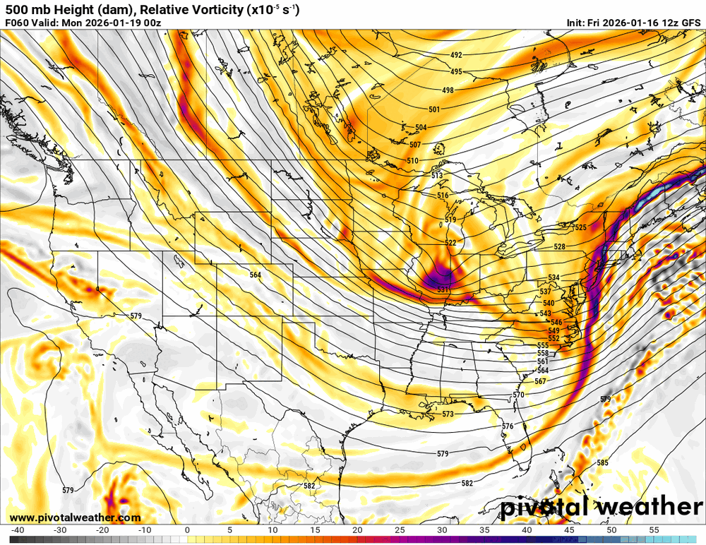
-

January 16-19th: Rolling the dice
NorthArlington101 replied to SnowenOutThere's topic in Mid Atlantic
The second I head to DCL the snow rockets back toward DC? Hate to see it -
I've been pretty adamant about the first phase 8 attempt being a fraud regardless of what the RMM charts had shown. Now, given the renewed MJO... Which still looks quite good to me for a real run at phase 8 this time on latest guidance btw... I'm more bullish on this run being more successful, but we'll see of course. Therefore, I believe the gefs is displaying the more plausible route forward. It's also slower with the MJO wave, which I believe would actually be the case. I think some of the RMM charts (EPS) posted lately are rushing it too much. Look towards the beginning of Feb or shortly thereafter for that potential IMO. This would support the idea of an energized Aleutian low/+PNA outcome such as the gefs is displaying. In addition, only one cluster on the extended range 00z EPS run from last night. So that means they're not helpful in showing different options in the extended this run. However, the one cluster that there is, does look to support the same idea also. Moreso than the smoothed out mean would suggest.
-

2025-2026 Fall/Winter Mountain Thread
ncjoaquin replied to Buckethead's topic in Southeastern States
We are darn close to back in the game for tomorrow. -
First Legit Storm Potential of the Season Upon Us
dendrite replied to 40/70 Benchmark's topic in New England
Maybe…not sure how much effect it would have on the orientation of the vortmax at that scale, but I guess the more data to initialize in the better. -
First Legit Storm Potential of the Season Upon Us
dendrite replied to 40/70 Benchmark's topic in New England
GFS is a lot more amped and NW. AI is a bit too. -
Were definitely trending in the right direction moisture wise for late tonight and tomorrow. Maybe we can get on the board for a change. Were overdue is a understatement. Good luck to all and especially the foothill crew.
-

Another Coating of Snow Saturday - "It's all we Got"
Damage In Tolland replied to Sey-Mour Snow's topic in New England
Well.Im riding the fence but just may be on right side of it -
First Legit Storm Potential of the Season Upon Us
Damage In Tolland replied to 40/70 Benchmark's topic in New England
AI’s FTW. Snowy weekend!! -
-
First Legit Storm Potential of the Season Upon Us
Sey-Mour Snow replied to 40/70 Benchmark's topic in New England
Will be very interesting for sure. Kind of a cool milestone if they score a coup. Still 30 hours to go time. Plenty will change .. -
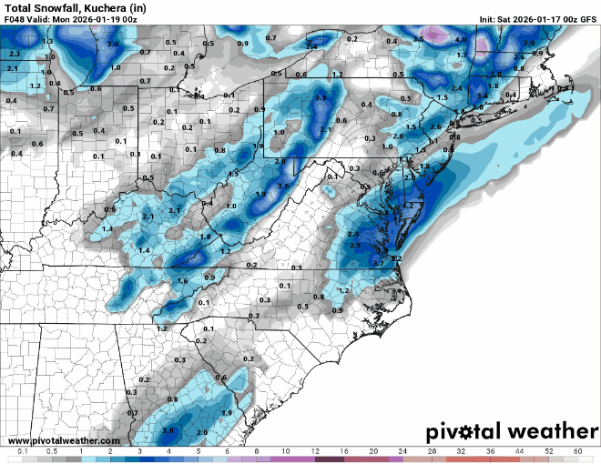
Best ensemble snowfall and agreement of the year, if not century...literally! 0z Eps, Geps, and Gefs in that order.
(10).thumb.png.fbe228abda306fe589690e69192a1a20.png)
(11).thumb.png.e5e8ec9acbe78dafa998a9ea6cb492d4.png)
(12).thumb.png.899116f31927d5ee721013875c6670ef.png)
-

Storm potential January 17th-18th
Bxstormwatcher360 replied to WeatherGeek2025's topic in New York City Metro
Lgt snow now falling here. Didn't take long .. 5 am. -
First Legit Storm Potential of the Season Upon Us
dendrite replied to 40/70 Benchmark's topic in New England
heh…yeah maybe. I still think they tend to broadbrush too much, but maybe it’s a signal if they’re significantly NW with QPF. We need one of those events with a sharp N cutoff to see if they can pin down tight gradients. -
January 2026 regional war/obs/disco thread
Sey-Mour Snow replied to Baroclinic Zone's topic in New England
It does , people just want results not great looking patterns. Hideously our luck turns tomorrow an we start cashing in on the digital snow. -
Wow, quite the change. Keep backing that thing up.
-
Another Coating of Snow Saturday - "It's all we Got"
Sey-Mour Snow replied to Sey-Mour Snow's topic in New England
Round 1 overperforming here, didn’t expect a flake may get an inch. Then it melts and maybe another inch. -
First Legit Storm Potential of the Season Upon Us
Sey-Mour Snow replied to 40/70 Benchmark's topic in New England
Like AI was trying to tell us -

First Legit Storm Potential of the Season Upon Us
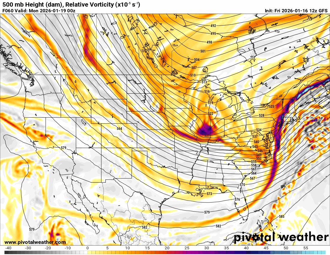
ineedsnow replied to 40/70 Benchmark's topic in New England
6z GFS came west.. wiz mentioned recon flying yesterday.. Just looked on tropical tidbits and they have another plane flying now.. I wonder if that data is getting into models now? -
First Legit Storm Potential of the Season Upon Us
Sey-Mour Snow replied to 40/70 Benchmark's topic in New England
GFS! Massive jump nw


(10).png.c3c294cbd8411ebc0bcc433deaf26acf.png)
(11).png.66b4ca138ee11dc8cc38583a49a6b30f.png)
(12).png.42b37e2fead3696a500391acc90ee7df.png)