All Activity
- Past hour
-
Picked up 1.13” from thunderstorm that rolled through. .
-

Central & Eastern Pacific Thread
Stormchaserchuck1 replied to Windspeed's topic in Tropical Headquarters
After we had a Cat 5 in the Atlantic on July 1 last year. There is definitely some uptick in potential energy in the tropics.. E. Pacific already going through 5 named storms in the 1st half of June.. -
Hottest day of the year so far here. 95.1
-
Yeah, it’s getting that 06z HRRR messy look. Have a couple of cells that have popped to the SW of here, but they’re behaving. Also another weakening sign, infrequent intra-cloud lightning with soft thunder. Sounds like one of those noise makers for sleeping.
-
85/73. These dewpoints are terrible.
-
2025-2026 ENSO
Stormchaserchuck1 replied to 40/70 Benchmark's topic in Weather Forecasting and Discussion
I'm just observing that the pattern seems to be breaking a little Obviously above average is the way to go, as something like 80% of the months across the US are above average over the last 5-10 years. This coming heat ridge is also a SE ridge flexing, but it's happening with a strong +NAO which isn't as bad, imo. -
Hopefully in Tolland and we take down a ton of trees and lines
-
Just took a 10 mile bike ride. Sure feels like summer out now.
-
-
2025-2026 ENSO
Stormchaserchuck1 replied to 40/70 Benchmark's topic in Weather Forecasting and Discussion
I actually really like this cold 500mb over Greenland for Winter -EPO potential.. it's a correlation that I've been working with over the past 12 years, strong +NAO periods are correlating with -EPO +time -
??? to grr
-
2025-2026 ENSO
Stormchaserchuck1 replied to 40/70 Benchmark's topic in Weather Forecasting and Discussion
Heating Oil Up 1.4% today, so you would have made 10-15% on a margined futures contract. I continue to have a strong signal for Heating Oil Up tomorrow.. about 57% chance. I finished this mathematical program 2 weeks ago, and so far it has outperformed the numbers in the first 2 weeks. Here's my list for tomorrow, just posting because it's weather related in that the coming heat ridge I don't think is fully baked into the Energy price yet. Crude Oil was down today, so Heating Oil has outperformed it all week so far, telling me that the weather might be outweighing Middle East conflict, at least in the last 3 days. Usually models catch onto a pattern 2 weeks out, but this one trended strong about 4-5 days ago. ZM -0.080% ZC -0.071% MXN/US -0.057% GBP/USD -0.015% USD/CN -0.014% ZF -0.008% VX -0.007% VIX -0.004% ZT -0.004% DKK 0.000% USD/CAD 0.000% USD/CHF 0.000% LE 0.000% EUR/USD 0.000% GC 0.014% GF 0.014% AUD/USD 0.016% NZD/USD 0.017% ZN 0.019% USD/JPY 0.020% ZW 0.041% HG 0.052% ZB 0.059% ZL 0.060% ZS 0.064% UB 0.069% PA 0.091% RB 0.094% HE 0.105% SI 0.108% NG 0.115% CL 0.179% PL 0.215% HO 0.342% -

2025-2026 ENSO
michsnowfreak replied to 40/70 Benchmark's topic in Weather Forecasting and Discussion
Wait...I like to talk about heat records? Actually, I like to talk about all weather records and cold/snow far, FAR outnumber heat when it comes to what i talk about. I know my local climate history like the back of my hand. My interest is local weather history and occasionally looking up other areas for certain things, events, etc. My thing is not spending hours, days, and weeks scouring through anything on xmacis or NCDC to find some rural middle of nowhere site I can plug into my latest post. BTW....its funny that you take coop data from 1903 at face value but have an entire laundry list of what is wrong with tons of official data (if you dont like the outcome). There are two upper peninsula stations that had official weather data in 1903. On July 1, 1903 Sault Ste Marie had a high/low of 76/60 while Houghton (closer to Baraga) had a high/low of 70/52. Downstate Detroit had a high/low of 90/70 with Lansing seeing 90/63 and Grand Rapids 84/67. Highs from north to south in MI on July 1, 1903 Houghton- 70/52 Baraga- 66/20 Sault Ste Marie- 76/60 Lansing- 90/63 Grand Rapids- 84/67 Detroit- 90/70 Yup, that 20F is completely believable -
Hoping to get 62 knots at BDL tomorrow
-
0.43" Eh, better than a complete miss. Really could use a 1"+ deluge.
-
62 knots IND!!!
-
We had another popup heavy shower just now.
-
1.1 from the downpour earlier to go with the 0.5 from last night for 1.6 on the day. Sunny and steamy out now
-
You hit 90? The warmest ambient station that I see in our area is 87 (I'm discounting the 93 as that can't be correct).
-
2025-2026 ENSO
michsnowfreak replied to 40/70 Benchmark's topic in Weather Forecasting and Discussion
Yeah and so you clearly missed the entire point of what was ORIGINALLY said. Im sure I can find cities with many below normal months since 2023. You cannot say anything on here without Bluewave and you going on a completely OT soapbox. -
It’s all your wanted cold rain and wet in summer . Thanks a lot
-
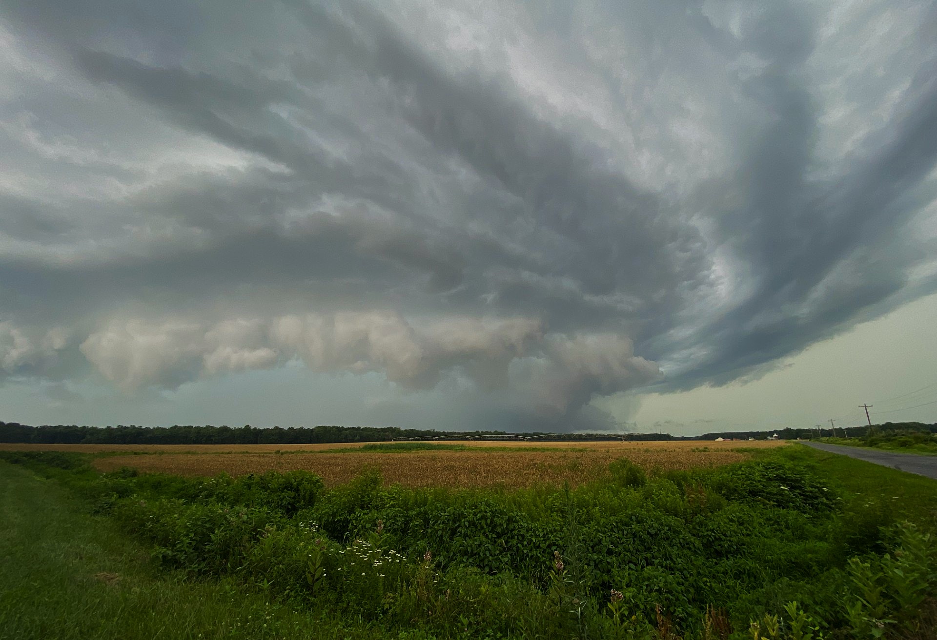
Looked like some rotation when I was watching it roll in. I post a pic in a bit.
-
IND about to get smoked
-
79° for the high here today. I think we had more clouds though. Colleagues in Moretown and Cambridge said they had sun while I still had overcast.