All Activity
- Past hour
-
Low of 57, high 83. Dew points climbed into the 60's today. Not as comfortable as the last 2 days.
-
:-) I coached my daughter's Class B softball team for a few years. Was really happy as they got older that we found a solid core of girls who genuinely liked each other and had good families. Made coaching a whole lot better. Watching that show brings back so many memories of the nut jobs we played against and kind of happy we are past that :-)
-

October Comes Early: Late September Multi-Hazard Hybrid Storm
dendrite replied to WxWatcher007's topic in New England
It would’ve been a good day to plant some seedlings today during the lulls. I’ll probably wait for a warmer, drizzly day in October though. -

October Comes Early: Late September Multi-Hazard Hybrid Storm
kdxken replied to WxWatcher007's topic in New England
In a wet year you wouldn't see a single Rock. Colors are beginning to blossom. Pretty working in the woods today although wet
.jpg.3089679d88673ede554c3e57f4c81c4b.jpg)
-
 Nothing shows those amounts there
 -
October Comes Early: Late September Multi-Hazard Hybrid Storm
kdxken replied to WxWatcher007's topic in New England
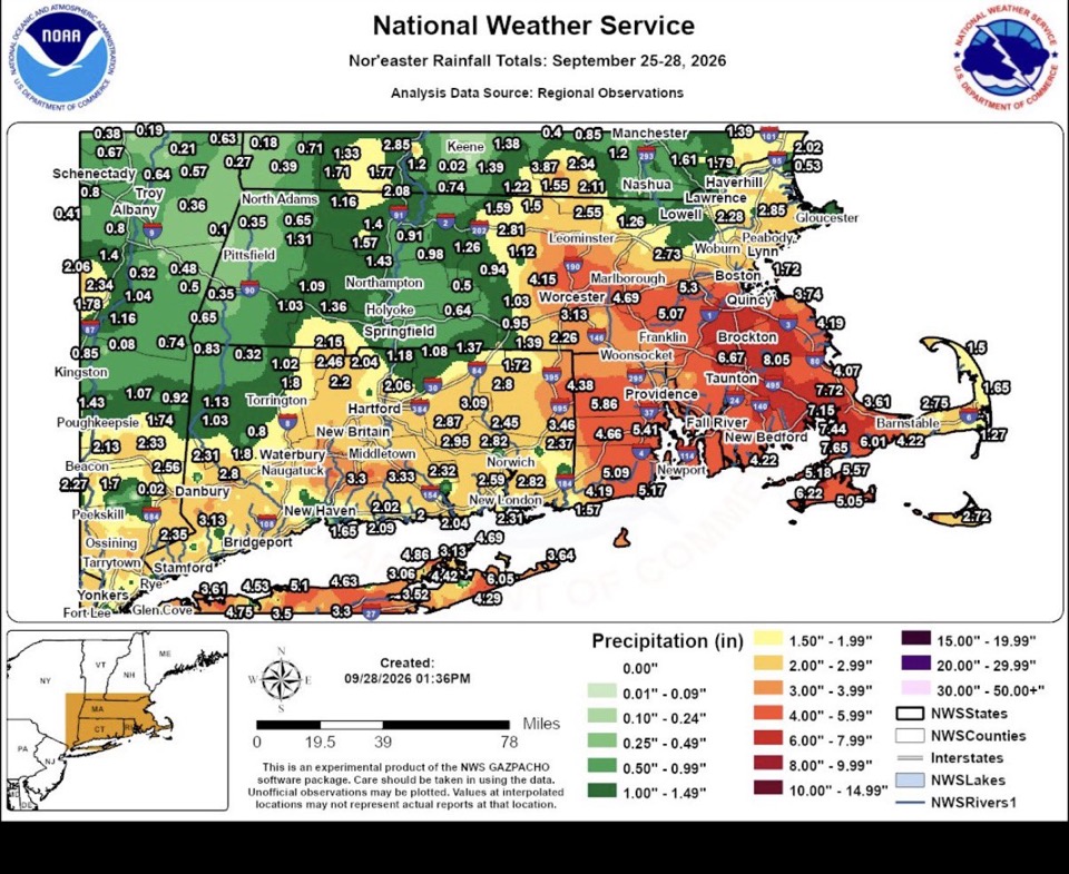
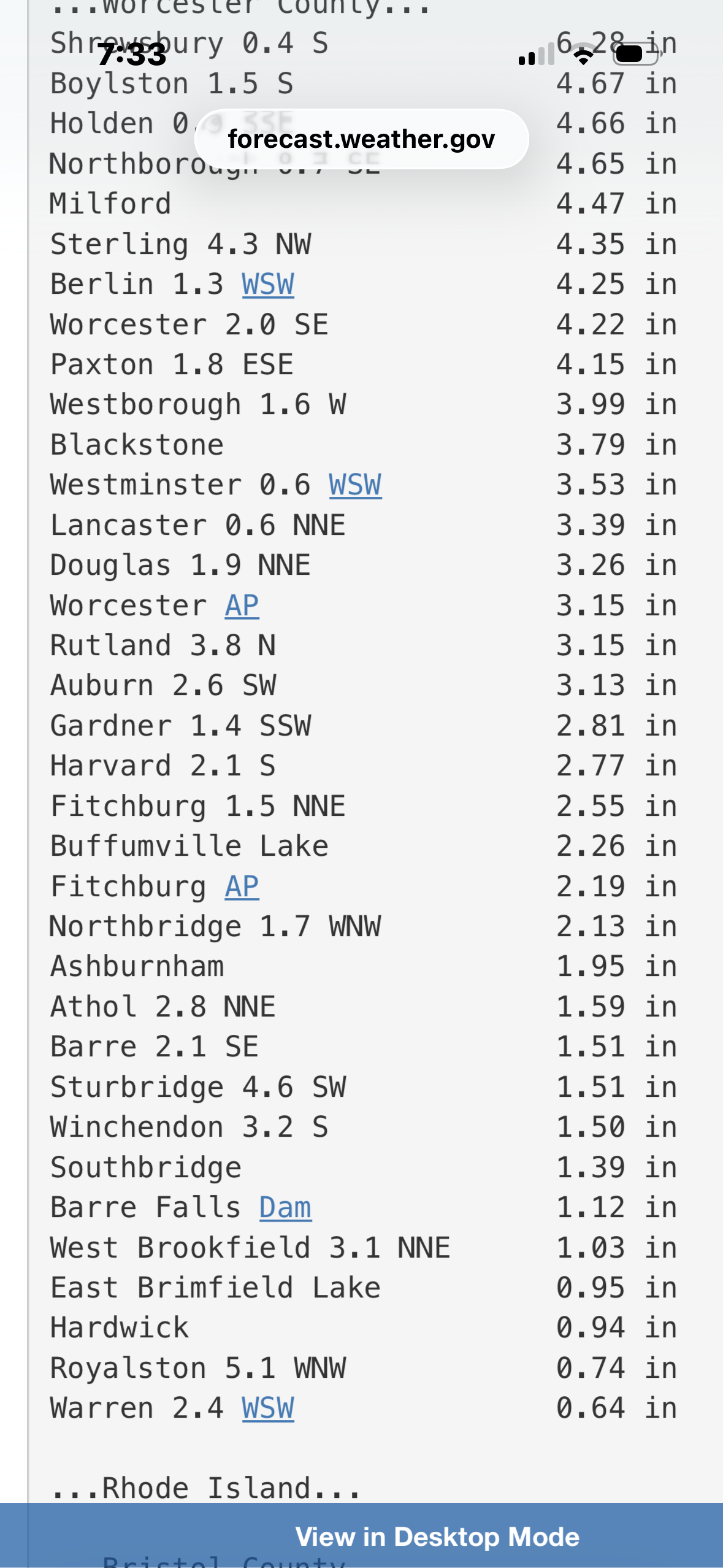
For 7 inches of rain it really didn't do that much. Ground handled it well. A little water in the basement of the old farmhouse but nothing dramatic. Back pond is still very low. Not that I want any more rain. -

October Comes Early: Late September Multi-Hazard Hybrid Storm
CoastalWx replied to WxWatcher007's topic in New England
About 7.5” so far -
Made a PDF report of winter storms from WV during that winter. Looks like some moisture bomb gulf lows translated to major winter storms for the ridges. Should bring some solace to know that even if we completely torch this winter snow, and maybe a blizzard, will only be a drive away. SED_events.pdf Charleston WV even has a map for a January event and notes the cutoff due to temperatures. Not sure I've ever seen a map like this! Look at the VA side, you have the blue ridge in Nelson county picking up over a foot of snow while the valleys had cold rain.
-
October Comes Early: Late September Multi-Hazard Hybrid Storm
kdxken replied to WxWatcher007's topic in New England
That's what I said in January of 2015. Has that familiar feel. Never ending. -
October Comes Early: Late September Multi-Hazard Hybrid Storm
kdxken replied to WxWatcher007's topic in New England
Nice envelope to get the bananas and tangerines in for next year. Ground is certainly moist enough. -
 sildenafil 50 mg price [url=https://sildendirect.com/#]SildenDirect[/url] Cheap Viagra 100mg
 -
Would you take the over or under for an 80 degree Halloween?
-
I think the PDO will move toward neutral as the fall and early winter progress. An active NPac storm track should foster some cooler water at the surface.
-
October Comes Early: Late September Multi-Hazard Hybrid Storm
dendrite replied to WxWatcher007's topic in New England
Yeah I may pass you on storm total. It’s been a steady sheet rain or drizzle for most of the day. Love it. Currently 52.5° +RA and 1.56” - Today
-
You can get away with lower temps (50's is as low as you want to go), but Dry and Calm are mandatory. Bugs are the biggest problem along with anything seeding out. I actually prefer fall for painting.
-

October Comes Early: Late September Multi-Hazard Hybrid Storm
renegade700 replied to WxWatcher007's topic in New England
Congrats just getting out there is half the battle! -
October Comes Early: Late September Multi-Hazard Hybrid Storm
78Blizzard replied to WxWatcher007's topic in New England
7.81" is the new total here now. -
yep, hoping for a stretch of AN weather next week, but it doesn't look like it's coming. I've custom ordered paint for my 3 older vehicles to touch up some rust repairs I've been making. Need a few days of warm, 70+ dry weather for the paint cure properly, and that doesn't look likely at this point in time.
-
So its like which years had the most similar weather pattern to 2026 spring+summer? just so i understand
-
Polo is approaching landfall. Shear is also affecting Polo, but it is now better aligned with the hurricane's vector of motion, which should mitigate any significant weakening prior to landfall. Intense convection is currently firing in the eastern and northern semicircles of the eyewall and spilling over the eye, giving an assymetric structure. However, we're close enough to landfall that it will likely remain officially a Category 3 landfall at this point since the last recon mission confirmed 100 kts. Morgerman is headed to the community of Las Barrancas, which still looks like a close point of landfall. If he nails the eye, he should get enough data to help confirm.
-
Yeah. We are not that crazy. Just a local rec travel team.
-
Anything but that.
-
1.63” for the day and event total of 2.48”.