All Activity
- Past hour
-
Exactly, getting to 98 or 99 is as annoying as a 98 or 99 on a test. 100 is perfection in both cases, so that would be ideal. 105 for extra credit lol.
-
Great news. I don't really care about Monday, maybe we'll finally have an exceptional day, not the mediocre heat of every summer since 2013.
-
I hope we hit 103 or 104 next week to tie or break the June record. If it's going to be tremendously hot, we might as well make it historic instead of just upper 90s to near 100. Very nice to get the break in the humidity today though. Feels good out there with dewpoints in the 50s. With sunshine and temps going to the mid 80s, this is a top 10 type of day for the summer. Perfect for outdoor activities.
-
Finally a free source has the 6z Euro. It looks like there's an ocean wind on Monday keeping the bad heat inland. Tuesday the winds go NW and everyone torches full blast.
-
After curb stomping us during winter, this is when we can +1 you guys lol.
-
Down there. Up here its currently 60.4°/56.5° overcast an breezy.
-

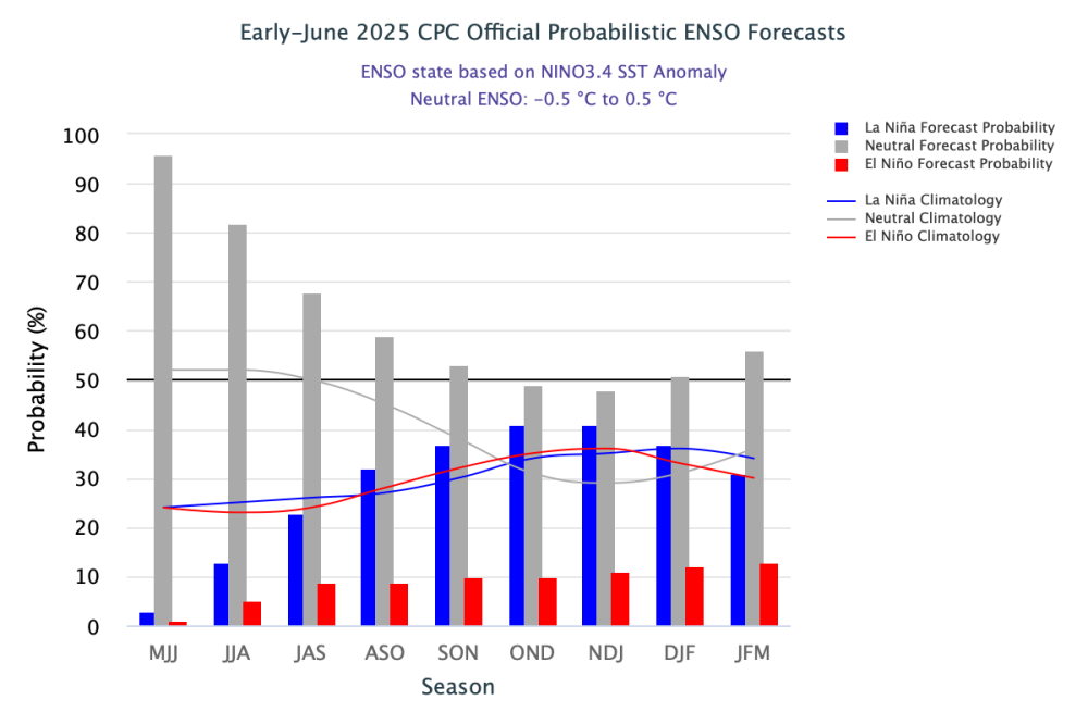
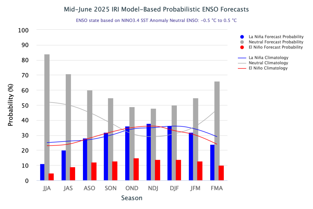
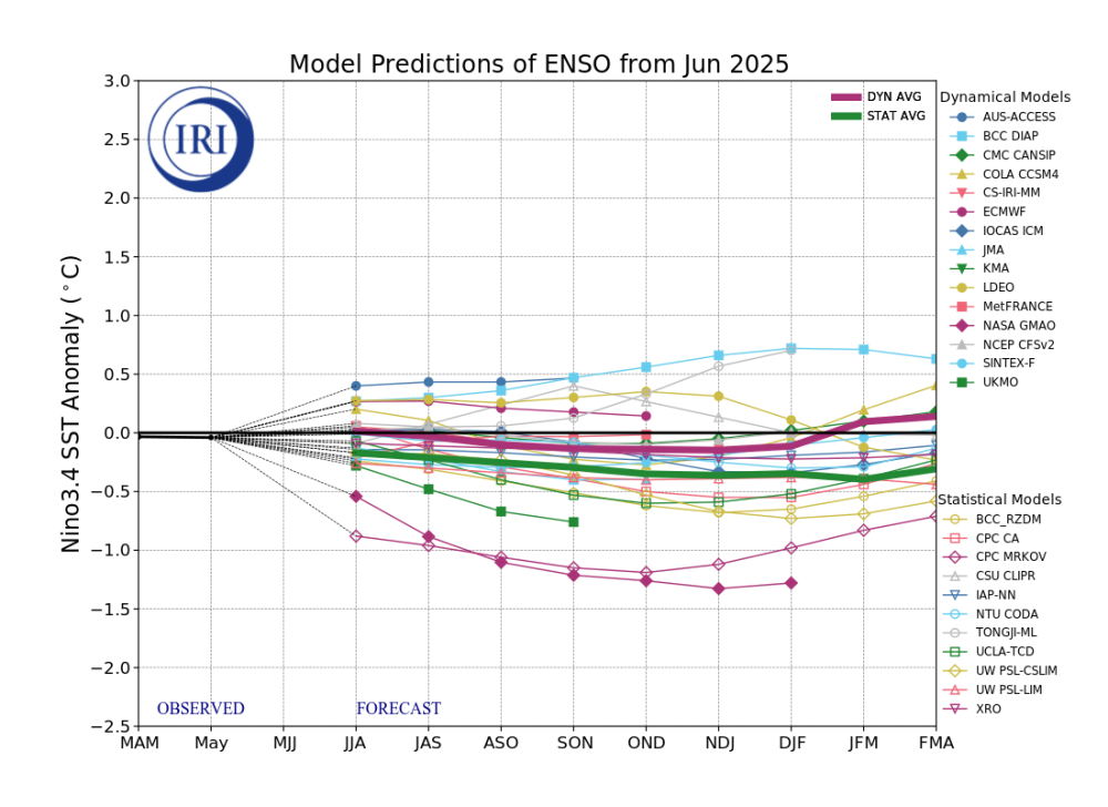
2025-2026 ENSO
PhiEaglesfan712 replied to 40/70 Benchmark's topic in Weather Forecasting and Discussion
-
5.08” for the week. Almost 14” since May 1st. Less than an inch behind 2018 for the wettest May-June combo in my 11-year record.
-
-
Perhaps the funniest thing, it didn't even reach 100F for any hour during last June's heat wave. Maybe the dewpoints are being overdone here for the upcoming stretch? Peak monthly heat index was below 85F in June 1976, 1977, 1985, and 2023. Edit: I do believe the 2023 figures are missing some observations, as there were a few hot days early in the month where the heat index must have been near 90F. The other three look correct, as monthly highs were 83-85F.
-
Since 1945, yes. Early data is actually from AGC, not PIT. With that said, there are some missing hours, and this would exclude any intrahour observations.
-
That's what SNE severe does to you.
-
But was it also easier to hit 100 back then because of lower moisture in the air (I'll use 1949 as an example even more than 1993 which is more recent.) So back then lower heights were needed to hit 100 than what we need now to do it?
-
Chris please note how 2022 is only on this list once, while years like 1949 and 1993 are on this list multiple times, they had many more 100+ days than 2022 did. 1993 is on this list twice while 1949 is on this list a whopping three times. It does seem like it was easier to hit 100 back then with lower heights, it must be because of lower humidity levels back then, more like a desert than the tropical rainforest we live in now.
-
The higher heights sometimes result in over the top warm ups where the warmest temperatures relative to the means get directed into Northern New England and Canada. That has happened several times in recent years. This was due to more onshore flow here due to the elongation of the ridge east of New England. But this time it appears that the westerly flow will be more pervasive. So we’ll have higher heights and westerly flow this time. So this is why somebody around the area could see the first 105° heat ever recorded during the month of June. June 2021 set the previous all-time record at 103°.
-
That sounds more like 1953 which had two of our most extreme heatwaves we've ever had with 4 100+ days split evenly between both (and our all time September record of 102).
-
In other words, excessive/extreme heat warning criteria have only ever been observed for two hours in Pittsburgh in June, on that day in 1978?
-
July 1993 had more 100+ days and the 100+ extreme heatwave it had in July was more extreme than the one in 2022 (it hit 105 the all time record at that time twice back then) and the extreme heat was much more widespread in 1993 as it covered the entire area-- NYC hit 100+ three days in a row and JFK two days in a row. It seems like we need higher heights for such extreme temperatures than we did back then (maybe it was easier to be hotter back then because the amount of moisture in the air was lower back then.)
-
Average temperature defines warmth but not hot. Here are the rankings I found: By the way, AI agrees with me and it seems that number of hot days correlates with average temperatures too. Here is AI's answer: What is the hottest summer on record in New York City? AI Overview The hottest summer on record in New York City was in 2010, with an average temperature of 77.8 degrees. This summer was hotter than the previous record of 77.3 degrees set in 1966, NYC has had a warming trend for years but there hasn’t been as many super hot days. In fact the 12 year gap between 100 degrees is the longest since 1881 - 1898 (and the 2nd longest in recorded history). Last year, despite being the warmest in NYC history by a significant margin (.6 warmer than any other year) the high was only 93. Here is the hottest summers page for NYC (AI agrees with me AI Overview New York City has experienced some extremely hot summers, with the hottest ones often occurring in the late 20th and early 21st centuries. The hottest summers since 1869, based on data from the National Weather Service, have all been since 1960, with 2010 being the hottest on record according to TypePad. The summer of 1966 had the hottest average monthly high temperature, while July 1999 had the hottest average daily temperature. Here's a breakdown of New York City's hottest summers: 2010: This summer is often cited as the hottest, with an average high temperature of 86 degrees Fahrenheit between June and August according to Yahoo. 1966: While 2010 had the hottest overall summer, 1966 holds the record for the hottest average monthly high temperature according to TypePad. 1999: This summer had the hottest average daily temperature in July. 1993: This year had the most 90-degree days during the summer months (35 days). Other Notable Summers: 1983 and 1991 also rank among the hottest summers in NYC's history. I also use Typepad for both summer and winter records, this site is a veritable bonanza of information. https://thestarryeye.typepad.com/weather/2012/07/revisiting-new-york-citys-hottest-summers-.html New York's five hottest summers (since 1869) have all occurred since 1960: 2010, 1966, 1993, 1983 and 1999. The fact that just one of the years is from this century may surprise some since these years were so warm worldwide. The summer of 1966, New York's second hottest on record, has the honor of having the hottest average monthly high temperature. Although July 1999 was the hottest month on record based on mean daily temperature (average of the day's high and low), the average high in July 1966 was hotter than July 1999 by 0.1 degree, 90.3° vs 90.2°. However, July 1999's average low was 3.5 degrees warmer (72.6° vs 69.1°) and that's what easily put it on top. Although 1991 and 1993 had the most 90-degree days for a calendar year, each with 39, 1993 had the most during the summertime period. It had 35, followed by 1966 with 34 and 2010 with 32. 1991 had 31, ranking fourth. https://www.weather.gov/okx/heatwaves This is the NWS Heatwave page for NYC National Weather Service New York, NY NYC Heatwaves Page Weather.gov > New York, NY > National Weather Service New York, NY NYC Heatwaves Page Current Hazards Current Conditions Radar Forecasts Rivers and Lakes Climate and Past Weather Local Programs Longest NYC Heatwaves Longest Heat Waves - 90 degrees + in a row (through March 10) Days Dates Temperatures 91,91,91,94,98,99,98,100,97,102,94,90 92,97,97,93,96,97,93,92,90,98,90 98,100,101,102,97,94,94,91,90,90 90,94,92,97,95,98,94,96,93,90 92,96,98,95,92,93,94,94,94 93,92,96,98,97,100, 102,92,104 91,93,91,91,91,94,99,101,95 93,94,91,94,92,91,93,93,91 96, 95, 95, 96, 97, 90, 92, 91 91, 92, 91, 94, 93, 94, 96, 95 98, 95, 98, 94, 95, 94, 96, 93 97, 102, 97, 96, 95, 95, 96, 95 91,91,93,95,95,100,100,94 93, 93, 91, 94, 96, 90,96 93, 93, 95, 94, 96, 99, 97 90, 93, 96, 99, 96, 100, 102 94, 93, 94, 98, 96, 93, 97 94, 95, 96, 93, 94, 94, 93 98, 100, 90, 95, 100, 97, 93 92, 97, 100, 101, 91, 90, 90
-
I'm waiting for some trees/limbs to start snapping.
-

E PA/NJ/DE Summer 2025 Obs/Discussion
The Iceman replied to Hurricane Agnes's topic in Philadelphia Region
Still no power this morning, current estimation is 11 pm tonight. One of the better storms we’ve had in awhile. Were there any confirmed wind readings? My anemometer on my station has been wonky for awhile so I don’t really trust it but I’d say they were easily in the 60-70 mph range. My 160 pound canoe flipped over from where I had it hanging on two barrels. From putting it there I can tell you it takes a lot of force to do that. Huge trees and branches down across the area too, think I read 15,000 in Levittown alone without power. One weird thing was how little lightning and thunder we had with it. -
Nice shelf cloud Sent from my SM-G970U1 using Tapatalk
- Today
-
I remember we had a Con Edison controversy (what else is new lol) when this happened a few years ago and the power went out in specific neighborhoods and not in other neighborhoods. I think that was in July 2019 when we had back to back 99 degree days with a heat index of 117 (at JFK). On a weekend too.
-

June 2025 discussion-obs: Summerlike
TheClimateChanger replied to wdrag's topic in New York City Metro
I don't think the NWS uses a specific temperature occurrence to rank summers. They track days over 90F, as they do lows and highs under 32F and lows under 0F in the wintertime, but seasonal rankings have always been by the average mean temperature (average of maximum and minimum). -
Looking at 101F or 102F for Raleigh around Tuesday. Absolutely awful. If I could move back to New England I would.


