All Activity
- Past hour
-
Down to 31 with light snow!
-
.thumb.jpg.6a4895b2a43f87359e4e7d04a6fa0d14.jpg)
Central PA Fall Discussions and Obs
Yardstickgozinya replied to ChescoWx's topic in Upstate New York/Pennsylvania
Definitely seems like we needed one with what's going down here right now. I don't know how hard the winds are blowing but they're blowing well over 25mph at this point, maybe even twice that with some of these gusts. -

Central PA Fall Discussions and Obs
canderson replied to ChescoWx's topic in Upstate New York/Pennsylvania
Guessing it didn’t get posted - very lax modding her now -
I hear ya I'd bang it.
-
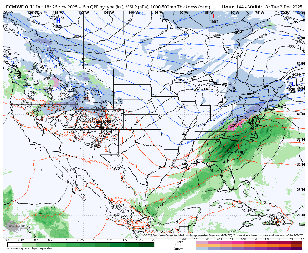
I don’t think that overall HRRR solution is too far off, but I would shift everything 10-15 miles ENE in terms of its placement. The RGEM and hi-res NAM are in decent enough agreement on band placement that I’d expect something close to those solutions.
-
Power is back. Thanksgiving is still on... for better or worse.
-
that was a good one. that is my measuring stick for a trackable threat. If the 18z euro or 6z euro have it..its close enough to take our interest to the next level
-
welcome to your 25th year on the message board and your still spouting the same stuff about models lol. You are probably 80 by now so i am going to give you a pass!
-

Central PA Fall Discussions and Obs
Blizzard of 93 replied to ChescoWx's topic in Upstate New York/Pennsylvania
18z Euro ends at 144 hours, but this run looks to be juicing up more in line with recent GFS runs.
-

Nov 28-30th Post Turkey Day Wintry Potential
sbnwx85 replied to Chicago Storm's topic in Lakes/Ohio Valley
This is it. 6-8", especially in November, is a big win. Hopefully sets the tone of the rest of the winter! -

December 2025 regional war/obs/disco thread
Damage In Tolland replied to Torch Tiger's topic in New England
Does it rain to Nashua or does it rain to Dendy . That we do not know yet -
Depends on track. Gfs was dicey for you with torched mid levels. If that low could intensify more it would help close things off.
-

2025-2026 New England Snow Recordkeeping Thread
dryslot replied to bristolri_wx's topic in New England
Got it, Thanks, Already updated the grid with the first total of the season. -
December 2025 regional war/obs/disco thread
Damage In Tolland replied to Torch Tiger's topic in New England
The question is.. how far are in ? Hunch or Freak -

December 2025 regional war/obs/disco thread
40/70 Benchmark replied to Torch Tiger's topic in New England
12" line is probably non-existent, but not the point. -
That 12” line probably is 30 miles north with those mid level lows.
-
December 2025 regional war/obs/disco thread
Damage In Tolland replied to Torch Tiger's topic in New England
Told ya -
It’s just nice to see some things lining up. This won’t be 2015, but I think we have chances extending through the month.
-
 Mowvember continues. 54 with drizzle/fog.
 -
December 2025 regional war/obs/disco thread
40/70 Benchmark replied to Torch Tiger's topic in New England
-
I think he said Mattapoisett? At least he can give us day boat scallops.
-

December 2025 regional war/obs/disco thread
H2Otown_WX replied to Torch Tiger's topic in New England
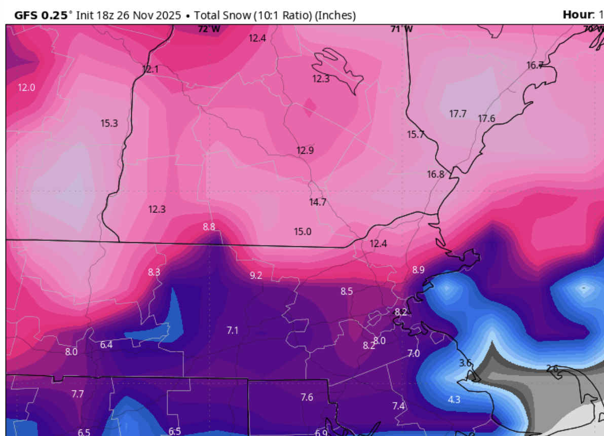
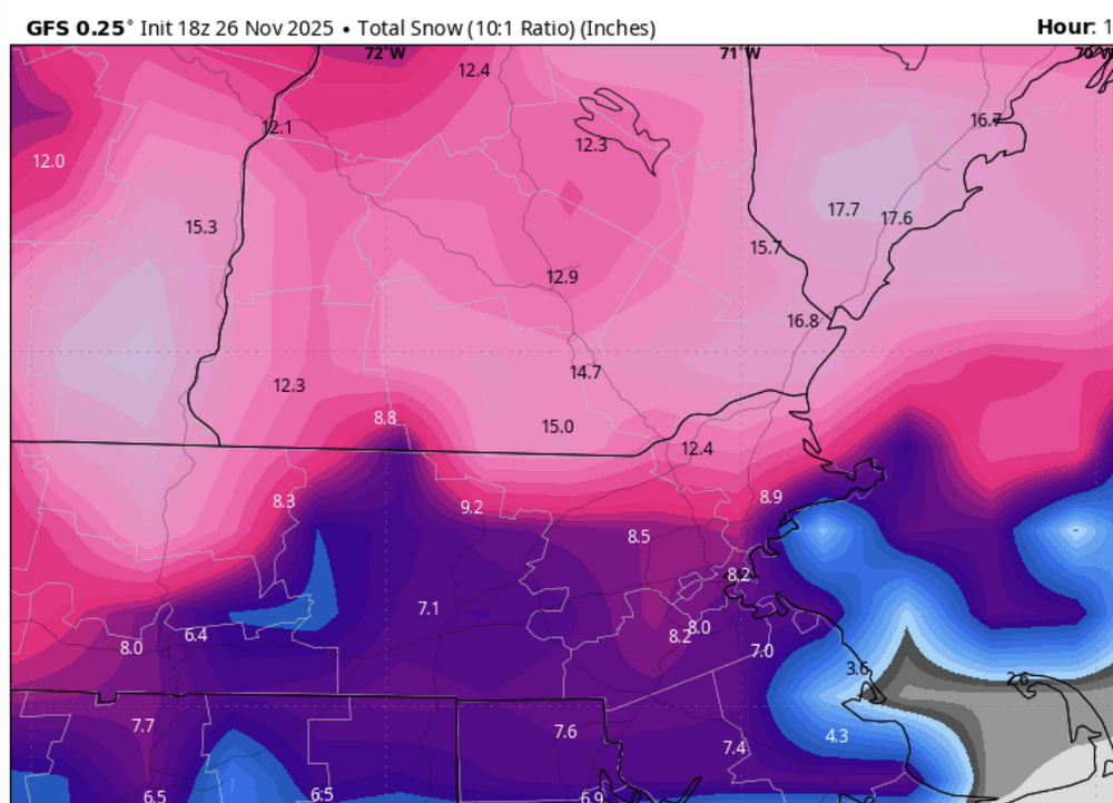
37"? -

Nov 28-30th Post Turkey Day Wintry Potential
weathafella replied to Chicago Storm's topic in Lakes/Ohio Valley
Hi fellow snow weenies. We’re camped out in Wilmette-looking good! I’m thinking 4-8. -
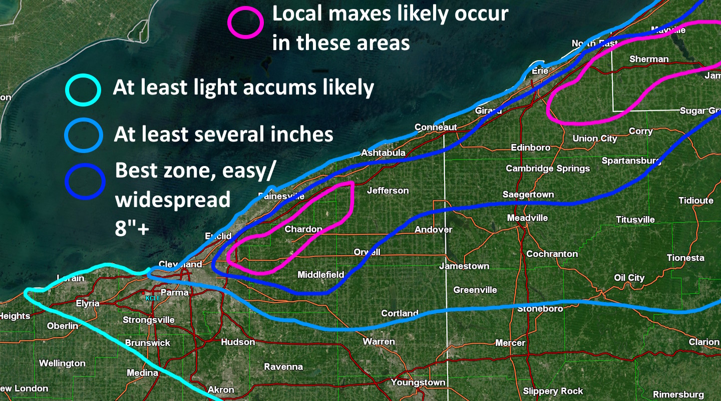
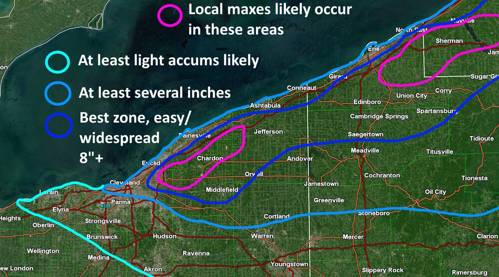
Definitely looks like the main show will be well north of me...curse of being a Summit County resident I suppose...though, still a pretty interesting looking event overall and some hopes I get some scraps down this way on Friday. Already starting to see some loosely organized lake effect taking shape over the lake and heading into the Buffalo/Niagara Falls area. The band should start pushing onshore from eastern Lake/northern Ashtabula Counties into northern Erie County PA overnight tonight. Winds lock in for several hours during the day Thursday...winds over the northern half of the lake will turn more WNW'rly, but winds closer to the south shore and on land over OH will remain more WSW or even SW through the day. So, I suspect we'll see a band that gets into a good portion of Lake County and probably far northern Geauga Thursday morning...extending east across northern/central Ashtabula, most of Erie County and perhaps extreme northern Crawford County in PA...but probably struggling to push much farther than that for most of Thursday. Through tonight, very strong boundary layer flow of 40-50kt over the lake, somewhat conditional instability, and the instability lift largely staying focused below the DGZ, all argue for snow rates remaining fairly under control. Conditions gradually improve through the day Thursday as the cold air deepens a bit and as the boundary layer flow over the lake weakens slightly, so we'll likely start seeing some 1" per hour rates within the heart of the band during the day Thursday. A pretty good shortwave crosses late Thursday afternoon/early evening, bringing winds around just a bit more and allowing for deeper cold air and moisture, with some Lake Michigan connection, to spread in. So, expect the band to push a bit farther south Thursday evening and really start to rip, quite possibly to the tune of 1-2" per hour. Soundings are most favorable Thursday night overall with equilibrium levels pushing to as high as 15k feet and deep moisture, to go along with decent lift and instability through the DGZ. The band probably will push into northern/eastern Cuyahoga, northern/central Geauga, much of Ashtabula, southern Erie and more of Crawford PA the first half of Thursday night. Another subtle trough crosses after midnight Thursday night, bringing a better push of WNW winds pre-dawn Friday. At that point, we should see activity expand into at least central/eastern Cuyahoga, southern Geauga/northern Portage, and northern/central Trumbull, though with the shorter fetch we may see the dominant band break up into upslope snow showers and weaker multi bands, with perhaps some lingering organization focused near Cuyahoga County. Activity may lull, or at least be fairly disorganized, for several hours during the day Friday. Winds begin backing late Friday into Friday night and there are decent signs of a last gasp type W-E band developing across Cuyahoga and into Geauga County Friday evening, and perhaps lasting a few or several hours before weakening/shifting farther NE late Friday night. I'll post a very rough map without real numbers on it (just wanted to draw something quick)...I do think the heaviest accums focus slightly inland given the very strong flow over the lake for most of the event, even if banding hangs up near the lakeshore for most of Thursday. I think eastern Cuyahoga into northern/central Geauga is a very good spot, as they'll probably get a lot of snow between late Thursday and early Friday with a little more Friday evening/night. It will be quite windy through Thursday with near blizzard conditions wherever the band is...winds gradually ease Thursday night into Friday but remain gusty enough for some blowing/drifting. I'll finally get a crack at the official forecast/AFD during the day tomorrow. The headlines currently out are reasonable, and our afternoon update today lowered things noticeably along the lakeshore and fine tuned peak amounts a bit and I don't think it's unreasonable at all. I may have the "fun" of deciding if Summit needs an advisory or if Trumbull needs a warning tomorrow, assuming neither upgrade is made on tonight's midnight shift.
-
December 2025 regional war/obs/disco thread
40/70 Benchmark replied to Torch Tiger's topic in New England