All Activity
- Past hour
-
Storm split, northern one fizzled out over me in Dumont. Southern one was the winner. Just drove through. Lots if thunder.
-
do we think there is actually a second round? Hoping evening pool isn’t in jeopardy - though late afternoon seems screwed
-
That's basically what the hrrr advertised this morning but we're about an hour ahead of schedule The hrrr is definitely showing alot more storm development In between the pft and cf an some of them look quite robust.
-
Did you hit 100 in July 1995?
-

E PA/NJ/DE Summer 2025 Obs/Discussion
RedSky replied to Hurricane Agnes's topic in Philadelphia Region
Looking at radar looks like storms move in around 5pm -
There are zero clouds here and yet we're under a severe thunderstorm warning until 4 pm lol
-
and I'm sure lapse rates aren't a huge deal TBH, 6C or 6.5C/km very doable 90/70ish. But you'd need slightly more dynamics, forcing, or shear. probably two of those three, to offset not having that bouyancy. Stronger forcing would have at least organized some of this stuff a bit more. Not great timing at all.
-
But it wasn't in 1966 either and that was our driest year on record, why was NYC cooler? I just think Queens and Nassau (both north and south shore) are hotter than Manhattan on an offshore wind because a westerly wind comes off Hudson River
-
Headed toward DC metro within the hour
- 1,108 replies
-
- 1
-

-
- severe
- thunderstorms
- (and 2 more)
-
I don't think that first line will expand north quickly enough for the Skook. I'm going to have to rely on, hopefully, some subsequent line(s) later.
-
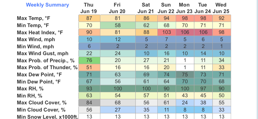
This is beginning to look like serious big league heat now. Maybe on one hand I can count days that ever got as hot as Monday/Tuesday are now forecasted to be.
-
Headed my way
-
It doesn't look as nice if it's cloudy
-
Radar definitely looks gnarly...I was able to mow this morning so i'm ready for some more rain
-
vere Weather Statement National Weather Service Baltimore MD/Washington DC 322 PM EDT Thu Jun 19 2025 VAC047-059-061-107-153-179-683-685-192000- /O.CON.KLWX.SV.W.0157.000000T0000Z-250619T2000Z/ Loudoun VA-Stafford VA-Fairfax VA-Fauquier VA-Culpeper VA- City of Manassas Park VA-Prince William VA-City of Manassas VA- 322 PM EDT Thu Jun 19 2025 ...A SEVERE THUNDERSTORM WARNING REMAINS IN EFFECT UNTIL 400 PM EDT FOR SOUTHEASTERN LOUDOUN...NORTHWESTERN STAFFORD...WESTERN FAIRFAX... EASTERN FAUQUIER...CENTRAL CULPEPER...AND PRINCE WILLIAM COUNTIES... THE CITY OF MANASSAS PARK AND THE CITY OF MANASSAS... At 321 PM EDT, a severe thunderstorm was located near Bealeton, or 8 miles southwest of Warrenton, moving east at 45 mph. HAZARD...70 mph wind gusts. SOURCE...Emergency management reports a history of downed trees with this line of storms. IMPACT...Damaging winds will cause some trees and large branches to fall. This could injure those outdoors, as well as damage homes and vehicles. Roadways may become blocked by downed trees. Localized power outages are possible. Unsecured light objects may become projectiles. Locations impacted include... Centreville, Dale City, South Riding, Broadlands, Brambleton, Warrenton, Dulles International Airport, Ashburn, Linton Hall, Sterling, Chantilly, Montclair, Bull Run, Triangle, Dumfries, Bealeton, Haymarket, Arcola, The Plains, and Manassas. PRECAUTIONARY/PREPAREDNESS ACTIONS... For your protection move to an interior room on the lowest floor of a building. Torrential rainfall is occurring with this storm, and may lead to flash flooding. Do not drive your vehicle through flooded roadways. && LAT...LON 3840 7801 3859 7782 3889 7786 3903 7743 3853 7731 TIME...MOT...LOC 1921Z 259DEG 40KT 3862 7789 THUNDERSTORM DAMAGE THREAT...CONSIDERABLE HAIL THREAT...RADAR INDICATED MAX HAIL SIZE...<.75 IN WIND THREAT...OBSERVED MAX WIND GUST...70 MPH
-
Yeah we see stuff pop more easily but the trade off is weaker activity. This is why pre-frontal troughs hurt us more often than not...once we get the convective temp reached we start popping too early. This is one reason why those EMLs are so important. they keep a lid on things until the strongest forcing can arrive
-
Very, Especially as you get here in the coastal plain and to the coast.
-
Skies are super dark to my west. May get clipped by one storm as it heads into PA. Larger storm behind it coming into Westminster now that should hit
- 1,108 replies
-
- 1
-
-
- severe
- thunderstorms
- (and 2 more)
-
Questionable
-
Why? Unless you sit in the sun who cares?
-
That cone is too far south. Weird
-
Woops, I think I forgot to empty my gauge from yesterday, so two day total is 2".
-
12z ICON now has cooler coasts and roasts the interior when previous runs roasted the coast as well.
-
Yeah, agree about those lapse rates; big-time bummer there and not sure NWS BOS or ALB discussed it at all. I was really expecting to see those dark greens? at least, 6.5 C/km or higher. Should have checked upstream soundings like you did OTOH stuff will pop more easily, less lid? I suppose. At least there's weaker stuff :/
-
are we already trying to skip this winter and wait for the 26-27 nino?


.thumb.jpg.6a4895b2a43f87359e4e7d04a6fa0d14.jpg)