All Activity
- Past hour
-
.thumb.gif.f92b16c631a1d15d405ed77b33f0710d.gif)
October Comes Early: Late September Multi-Hazard Hybrid Storm
Torch Tiger replied to WxWatcher007's topic in New England
Yeah a very boring and ugly solution -
They don't get much stronger.
-

October Comes Early: Late September Multi-Hazard Hybrid Storm
Brian5671 replied to WxWatcher007's topic in New England
Saturday doesn't look great either with the wind and rain moving in -

October Comes Early: Late September Multi-Hazard Hybrid Storm
dendrite replied to WxWatcher007's topic in New England
If my apple picking is going to be ruined we better get 1”+ out of it up here. Thank you for your attention to this matter. -

Winter 2026-2027 Seasonal Outlook
olafminesaw replied to WinstonSalemArlington's topic in Southeastern States
I'm seeing the image -

October Comes Early: Late September Multi-Hazard Hybrid Storm
CoastalWx replied to WxWatcher007's topic in New England
At least you guys could really use the rain. -

October Comes Early: Late September Multi-Hazard Hybrid Storm
Sey-Mour Snow replied to WxWatcher007's topic in New England
Meh, besides coastal flooding and erosion being maximized with the loop and Astro high tides this is just a rainy Nor’Easter that ruins another Sunday. -
October Comes Early: Late September Multi-Hazard Hybrid Storm
dendrite replied to WxWatcher007's topic in New England
-

October Comes Early: Late September Multi-Hazard Hybrid Storm
WinterWolf replied to WxWatcher007's topic in New England
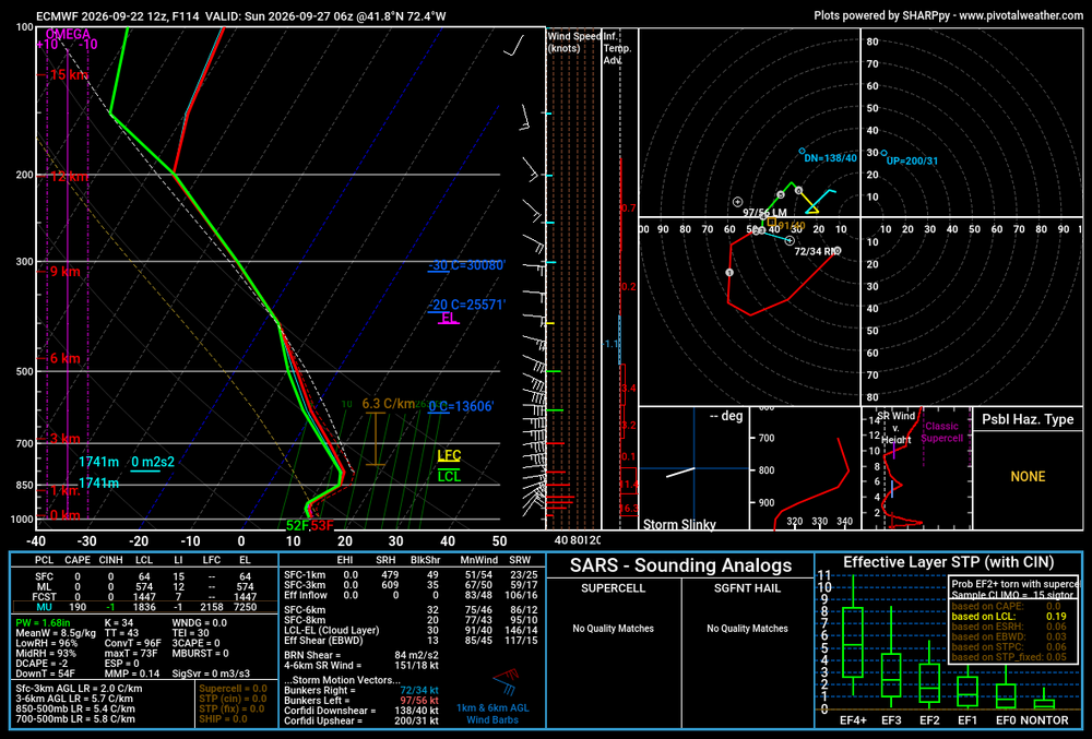
A lot of uncertainties still Kev…if this thing really amps up into a powerhouse, then ya sure the winds could crank inland. If it’s a weak dog, forget it. We have a couple more Days to see how things come together. -

October Comes Early: Late September Multi-Hazard Hybrid Storm
tiger_deF replied to WxWatcher007's topic in New England
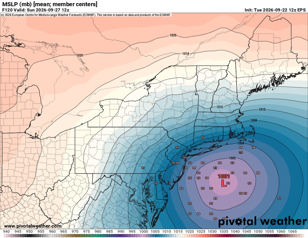
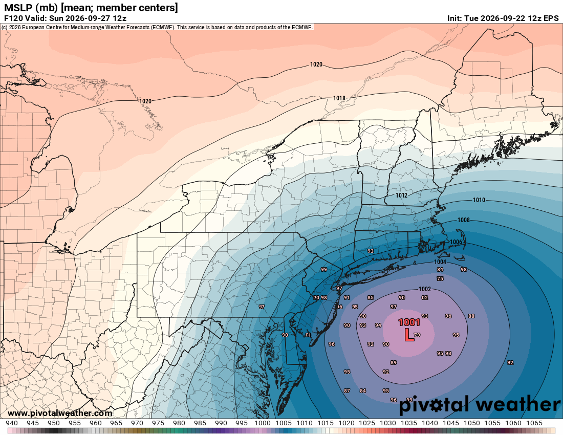
Give me that 975 mb ensemble member please -
October Comes Early: Late September Multi-Hazard Hybrid Storm
CoastalWx replied to WxWatcher007's topic in New England
Deep mind still has two clusters but a big cluster south of eastern Long Island to Block Island. Seems to be a lot of members sort of stall and spin in that area before wobbling back northeast. Seems to be a decent consensus around that spot I think. -

October Comes Early: Late September Multi-Hazard Hybrid Storm
ineedsnow replied to WxWatcher007's topic in New England
just once I want a storm like this shooting up the coast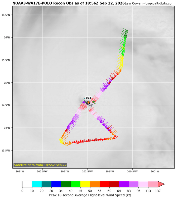
-
 Vort95 will have some thoughts for you i believe.
 -

2026-2027 Record-breaking El Nino
michsnowfreak replied to Stormchaserchuck1's topic in Weather Forecasting and Discussion
Feb 1998 actually had a huge snowstorm in southern OH and northern KY, but I dont think it was very widespread. Feb was the torchiest month of the 1997-98 winter while Dec was the torchiest month of the 1982-83 winter. Typically December is the warmest month in strong Ninos but 1997-98 proved that wrong. I just cringe everytime you guys wish for 1983. Absolutely the worst strong Nino of them all here. Although certainly some bad luck played a factor. -
About 75-80 miles S of Chicago .Mostly cornfields.. Haha
-
October Comes Early: Late September Multi-Hazard Hybrid Storm
CoastalWx replied to WxWatcher007's topic in New England
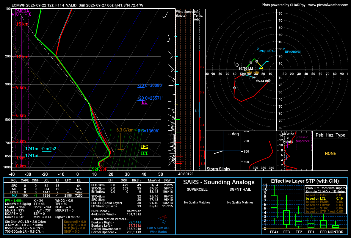
It’s still uncertain to me how much wind the interior sees. You guys are gonna be wedged it’s gonna be pretty darn cool at the surface. So that’s gonna hold back some mixing there. It depends on the track and how strong this thing is. -

Septorcher 2026 Discussion - Endless Summer
WxWatcher007 replied to Damage In Tolland's topic in New England
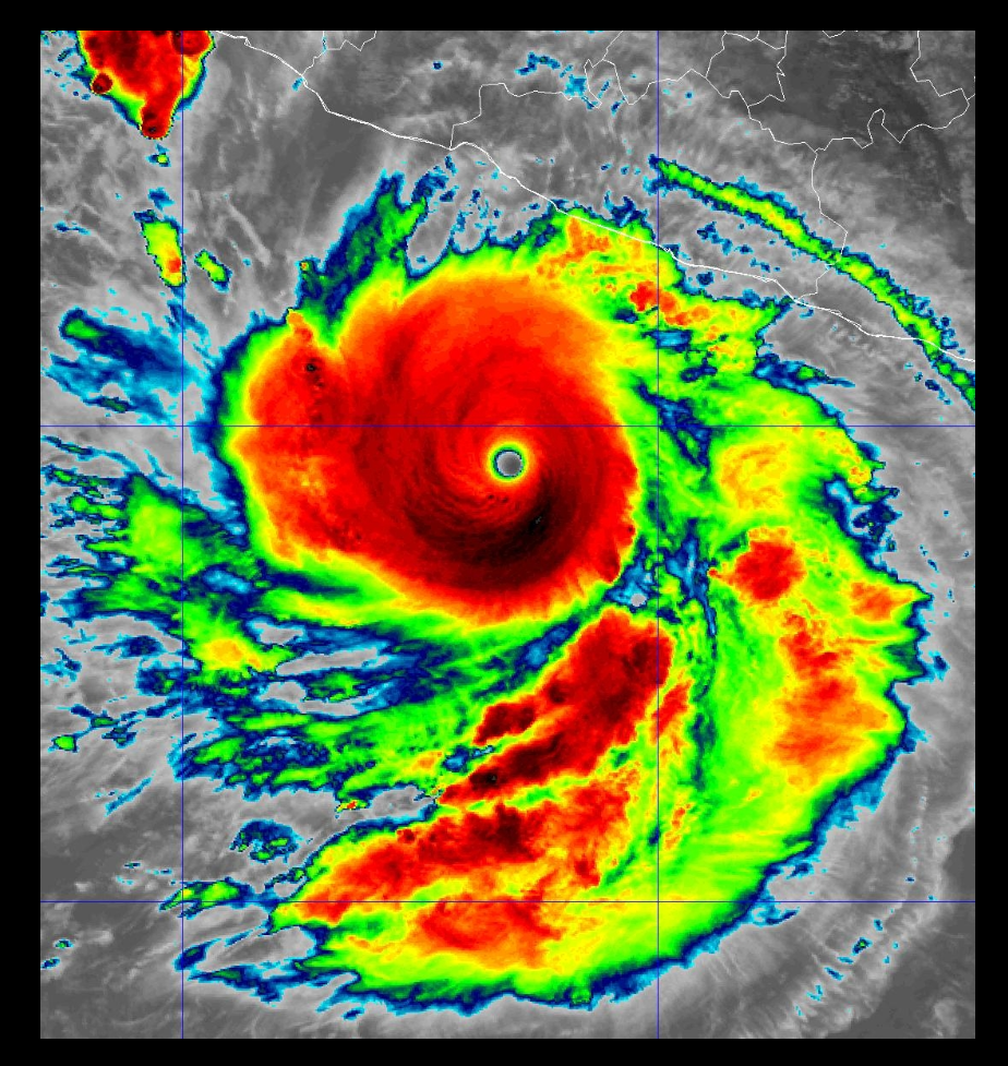
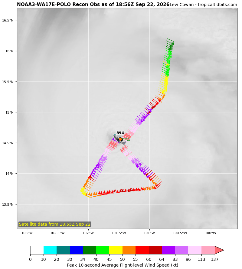
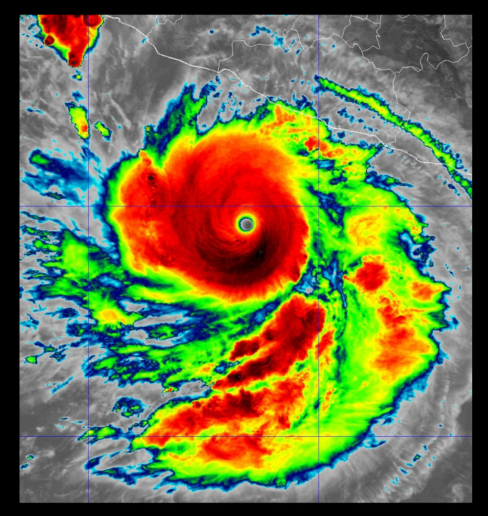
Hurricane Polo Tropical Cyclone Update NWS National Hurricane Center Miami FL EP172026 100 PM CST Tue Sep 22 2026 ...HURRICANE HUNTER AIRCRAFT FINDS POLO HAS STRENGTHENED EVEN MORE... Reports from a NOAA Hurricane Hunter aircraft indicate that the maximum winds in Hurricane Polo have increased to near 180 mph (285 km/h) with higher gusts. The minimum central pressure has dropped to 892 mb...26.34 inches. Polo is nearly stationary but is expected to move generally west-northwestward over the next couple of days. SUMMARY OF 620 AM AST...1020 UTC...INFORMATION ---------------------------------------------- LOCATION...14.6N 101.5W ABOUT 210 MI...335 KM S OF ZIHUATANEJO MEXICO ABOUT 360 MI...575 KM SSE OF MANZANILLO MEXICO MAXIMUM SUSTAINED WINDS...180 MPH...285 KM/H PRESENT MOVEMENT...STATIONARY MINIMUM CENTRAL PRESSURE...892 MB...29.59 INCHES $$ Forecaster Pasch/Hagen -

2026-2027 Record-breaking El Nino
LakePaste25 replied to Stormchaserchuck1's topic in Weather Forecasting and Discussion
If CFS is going off how NOAA is calculating it, that model output makes more sense. Interesting to see the difference as Cyclonicwx’s is closer to Australian BOM’s RONI measurement. -
GFS/Canadian/Ukie Vs. Euro's - the HP location will have the final say IMO Even with the strong NE flow today the warm water temps and breaks of sun allowed North Central NJ temps this afternoon to reach 70 expect the same right into the weekend - Upton not expecting much rain this weekend only 40% chance of showers according to PM update ZFP from KOKX Quote
-
One of those somewhat rare deals where interior has more wind issues than coast with this in terms of trees and lines out of a direction trees are not used to gusts from that direction.
-
2026 C and E Pacific tropical activity
WxWatcher007 replied to GaWx's topic in Tropical Headquarters
And there’s your update Hurricane Polo Tropical Cyclone Update NWS National Hurricane Center Miami FL EP172026 100 PM CST Tue Sep 22 2026 ...HURRICANE HUNTER AIRCRAFT FINDS POLO HAS STRENGTHENED EVEN MORE... Reports from a NOAA Hurricane Hunter aircraft indicate that the maximum winds in Hurricane Polo have increased to near 180 mph (285 km/h) with higher gusts. The minimum central pressure has dropped to 892 mb...26.34 inches. Polo is nearly stationary but is expected to move generally west-northwestward over the next couple of days. SUMMARY OF 620 AM AST...1020 UTC...INFORMATION ---------------------------------------------- LOCATION...14.6N 101.5W ABOUT 210 MI...335 KM S OF ZIHUATANEJO MEXICO ABOUT 360 MI...575 KM SSE OF MANZANILLO MEXICO MAXIMUM SUSTAINED WINDS...180 MPH...285 KM/H PRESENT MOVEMENT...STATIONARY MINIMUM CENTRAL PRESSURE...892 MB...29.59 INCHES $$ Forecaster Pasch/Hagen -
Where are you located now?
-
Full moon too. Yes it would be ugly for the coasts.
-

October Comes Early: Late September Multi-Hazard Hybrid Storm
Bostonseminole replied to WxWatcher007's topic in New England
yeah maybe 40-50 max gusts -
October Comes Early: Late September Multi-Hazard Hybrid Storm
ineedsnow replied to WxWatcher007's topic in New England
EPS