All Activity
- Past hour
-
Totally different from the Euro for NNE.
-

-
for me the highest storm in 2014 was the overpreforming vday storm with ~19" here, 20-26" in the ridges north of me
-
i want to believe would take what the nest is selling obv
-
Ok I just looked. What is all of that showing up?
-
We've potentially reached the extent minimum on Jaxa (4.55 mil sq km on 9/8). We're about 50k above that now. We'll see if there are enough drops in the coming week to offset gains. If we have indeed reached the extent minimum, it would rank 14th lowest. Area is even murkier...we're only about 10k above the min of 2.70 million sq km. We're currently 5th lowest for area. We'd need to drop below 2.63 million sq km to reach 4th lowest.
- Today
-
UKMET (12Z) again has the lemon as a TS in the MDR. It develops it 18 hours later. Unlike last run, this one has it already recurving out of the MDR way out in the middle of nowhere: NEW TROPICAL CYCLONE FORECAST TO DEVELOP AFTER 120 HOURS FORECAST POSITION AT T+120 : 18.5N 45.0W LEAD CENTRAL MAXIMUM WIND VERIFYING TIME TIME POSITION PRESSURE (MB) SPEED (KNOTS) -------------- ---- -------- ------------- ------------- 1200UTC 17.09.2025 120 18.5N 45.0W 1006 39 0000UTC 18.09.2025 132 19.9N 46.2W 1006 39 1200UTC 18.09.2025 144 22.6N 48.3W 1006 43 0000UTC 19.09.2025 156 24.3N 50.8W 1006 36 1200UTC 19.09.2025 168 25.2N 52.2W 1005 41 ————- Also, this run doesn’t have the 2nd TC that the prior run had.
-
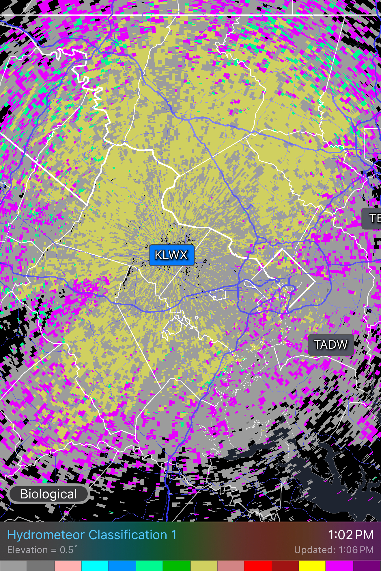
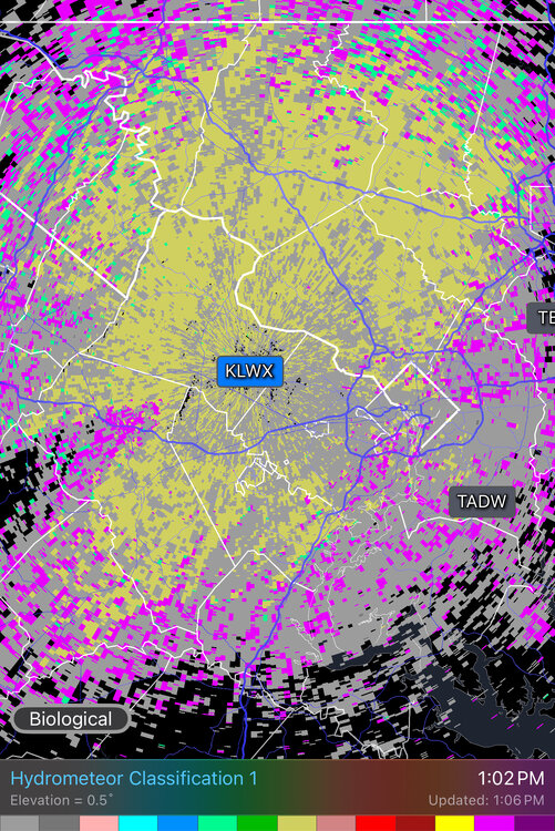
The radar algorithm is nicely split between biological scatterers and large hail.
-
70/51. Doesn't get much better.
-
And JB has been talking like there’s been significant cooling that he attributes to undersea seismic activity. But in this case (Sept 1-10) it’s ~0.2C cooler than 2 years that were a whopping 0.4 warmer than the prior year. Imagine how 2025 would stick out like a warm thumb had 2023 and 2024 not been on the graph! Edit: Aside: I still have to wonder why there was that 0.4C spike up and whether or not that undersea volcanic explosion bringing tons of H2O into the atmosphere had something to do with it. It’s awfully coincidental timing!
-

September 2025 OBS-Discussion centered NYC subforum
Stormlover74 replied to wdrag's topic in New York City Metro
Been pretty cloudy here all morning -

2025 Lawns & Gardens Thread. Making Lawns Great Again
SJonesWX replied to Damage In Tolland's topic in New England
that's called the "fuck you" grass. as in: fuck you, we can grow where you don't want us to, but can't grow where you need us. -

September 2025 OBS-Discussion centered NYC subforum
SACRUS replied to wdrag's topic in New York City Metro
Up to 76 but an area of clouds rolling through now more sunny -
66/47°F under clear skies.
-
Anyone ever play The Ranch in Southwick, MA?
-
The answer was mostly straight holes with well positioned bunkers and tricky greens. The drought impacting northern New England hit the course hard as only thing green was the greens. A bullet tee shot would roll for ever to the point it felt like a 350 yd hole was drivable.
-
Last actual KU for the mid atlantic was February 2021 then. For SNE it was Jan 2022. I doubt a KU happens next winter, or even a widespread 10" event from philly to nyc. Boston is a different climo they can get 10" storms even in bad winters.
-

2025-2026 ENSO
40/70 Benchmark replied to 40/70 Benchmark's topic in Weather Forecasting and Discussion
I guess I am talking about widespread 20"+.... -
Anything above 6" is KU material for central park now lmfao. Central park has not gotten a 6" event since January 2022.
-

2025-2026 ENSO
donsutherland1 replied to 40/70 Benchmark's topic in Weather Forecasting and Discussion
Boston and eastern MA largely missed out on that event and it turned to heavy rain for the New York City area for a time. But even with a swath of 10"-20" snows, that event wasn't a high-end KU storm. It was a Category 3 event on the NESIS scale. -
2025-2026 ENSO
40/70 Benchmark replied to 40/70 Benchmark's topic in Weather Forecasting and Discussion
I guess that is KU material for you guys, but certainly not something I would consider high-end. -
Highest snowfall that year for me was 14” if I remember correctly
-
2025-2026 ENSO
40/70 Benchmark replied to 40/70 Benchmark's topic in Weather Forecasting and Discussion
2013-2014 also didn't have any higher end KU events if I am not mistaken....perhaps I am, not sure. But I know for my area, there were no really memorable events, which are tougher to achieve without a well placed PNA ridge. It's much easier to get more moderate snowfalls, which is mostly what we saw. Anyway, like I said...no absolutes. You don't absolutely NEED the PNA to cooperate...you can still time everything perfectly, but it's just much tougher. -
2025-2026 ENSO
40/70 Benchmark replied to 40/70 Benchmark's topic in Weather Forecasting and Discussion
It's much easier to have east coast winter weather in general without an active PAC jet...I'm not arguing it's favorable. But it's not the only reason the east coast has been struggling. The pattern has sucked. We did manage a -WPO in 2021-2022. -
Much easier to get a strong -WPO with a relaxed Pacific Jet not constantly eroding the ridge.