All Activity
- Past hour
-

E PA/NJ/DE Winter 2025-26 Obs/Discussion
Ralph Wiggum replied to LVblizzard's topic in Philadelphia Region
Best in a Nina to just focus on 5 days out. When you start unicorn hunting 2-weeks out, you are setting yourself up for disappointment. Should be some decent squalls around next 36 hrs off and on. -

New Years Day 2026 - 1st snows of the new year possible
Damage In Tolland replied to Baroclinic Zone's topic in New England
1-4 west to East -

Central PA Winter 25/26 Discussion and Obs
Voyager replied to MAG5035's topic in Upstate New York/Pennsylvania
Timing of the squalls could line up perfectly for ringing in the New Year. Someone might have a whiteout at exactly 12 midnight. -
16.1 this morning.
-
January 2026 Short/Medium Range Thread
Save the itchy algae! replied to John1122's topic in Tennessee Valley
The SEC isn’t as overrated as the Big 10, so there’s that! However fanbases of both of those conferences generally have no idea how terrible CFB has gotten. You guys are only just now seeing surface level stuff. And yes the sec and big 10 did it to the sport. I hope some humility finds its way back into the sport so that way people remember what made CFB great. The bluebloods have become absolute vampires, and not the sexy kind. It’s killing the spirit of the game. -

Central PA Winter 25/26 Discussion and Obs
Mount Joy Snowman replied to MAG5035's topic in Upstate New York/Pennsylvania
24 when I left the house. Some light radar returns overhead this morning but nothing was reaching the ground. Excited to see who can catch a squall later tonight. Hope everyone has a fun a safe New Year’s Eve. -

12/31-1/1 Possible Snow Showers/Squalls to Start 2026
stormy replied to bncho's topic in Mid Atlantic
I support Capes thoughts completely. This is no-mans land during winter. -

Central PA Winter 25/26 Discussion and Obs
mahantango#1 replied to MAG5035's topic in Upstate New York/Pennsylvania
-

New Years Day 2026 - 1st snows of the new year possible
Sey-Mour Snow replied to Baroclinic Zone's topic in New England
Impressive snow squall threat tomorrow around daybreak.. Looks like a summer time squall line.. Probably looking at coating to an inch tonight away from SE New England and Maine. Then another coating to an inch or so with the squalls tomorrow morning. -
Central PA Winter 25/26 Discussion and Obs
mahantango#1 replied to MAG5035's topic in Upstate New York/Pennsylvania
-
January 2026 regional war/obs/disco thread
Sey-Mour Snow replied to Baroclinic Zone's topic in New England
GFS is like 150 miles north every run since yesterday, a few more moves like that and we have something, still 4.5 days out ... Heres GEFS trend
-

12/31-1/1 Possible Snow Showers/Squalls to Start 2026
Eskimo Joe replied to bncho's topic in Mid Atlantic
-

January 2026 Short/Medium Range Thread
Holston_River_Rambler replied to John1122's topic in Tennessee Valley
It's amazing how quickly the deterministics flipped. It seems like they were locked in on some sort of storm tracking east of the Mississippi for a week's worth of runs and the we had that massive storm on an 18z run Monday. I don't think there was any sort of a step down process. It's like they were drinking over Christmas and then sobered up and said "pattern conducive for eastern snow? No says I !" It may be the MJO is about to come out in 6 like y'all said over night. I saw GaWx mentioning that yesterday on the GFS suite's RMMs. Perfect timing I guess, lol. It looks like it is getting riled up on the less favorable regions: If that is really what is going on, it'll take it at least a couple of weeks to cycle through into the Western Pac and would line up with what the OP Euro and GFS (non AI) showed over night. La Nina and MJO over the Maritime continent seems to = ye olden qpf fire hose. The other thing I noticed was that the long prophesied jet extension isn't quite as extensive as promised and that I supposed that would tend to pull the whole pattern back west some too. -

New Years Day 2026 - 1st snows of the new year possible
klw replied to Baroclinic Zone's topic in New England
This was about the perfect "medical ad" -
Yes but you are not including the posts with whinging about people whining or the post with people whining about people whinging about people whining. But by the forum standards yes there is not too much whining.
- Today
-

12/31-1/1 Possible Snow Showers/Squalls to Start 2026
WxUSAF replied to bncho's topic in Mid Atlantic
Nada IMBY -
21 in Ashburn
-

New Years Day 2026 - 1st snows of the new year possible
moneypitmike replied to Baroclinic Zone's topic in New England
BOX going for 2-4" for Pit 1 GYX calling for 3" at Pit2. I'll call that a win. -

E PA/NJ/DE Winter 2025-26 Obs/Discussion
Duca892 replied to LVblizzard's topic in Philadelphia Region
So it seems like our awesome pattern change already is playing kick the can down the road…? It seems like almost every year this happens and it just gets pushed farther and farther out lol -
Central PA Winter 25/26 Discussion and Obs
mahantango#1 replied to MAG5035's topic in Upstate New York/Pennsylvania
Hazardous Weather Outlook National Weather Service State College PA 333 AM EST Wed Dec 31 2025 PAZ012-018-019-025-034-037-041-042-045-046-049>053-058-010845- Northern Clinton-Northern Centre-Southern Centre-Blair-Bedford-Tioga- Northern Lycoming-Sullivan-Southern Clinton-Southern Lycoming-Union- Snyder-Montour-Northumberland-Columbia-Schuylkill- 333 AM EST Wed Dec 31 2025 This Hazardous Weather Outlook is for central Pennsylvania. .DAY ONE...Today and tonight. 1 to locally 3 inches of snow is expected this afternoon through Thursday morning. In addition, A line of snow showers/squalls will move through during the evening hours this New Year`s Eve. If a Snow Squall Warning is issued for your location, delay travel or exit the highway at the next opportunity. Hazardous Weather Outlook National Weather Service State College PA 333 AM EST Wed Dec 31 2025 PAZ026>028-035-036-056-057-059-063>066-010845- Huntingdon-Mifflin-Juniata-Fulton-Franklin-Perry-Dauphin-Lebanon- Cumberland-Adams-York-Lancaster- 333 AM EST Wed Dec 31 2025 This Hazardous Weather Outlook is for central Pennsylvania. .DAY ONE...Today and tonight. A line of snow showers/squalls will move through during the evening hours this New Year`s Eve. If a Snow Squall Warning is issued for your location, delay travel or exit the highway at the next opportunity. -

12/31-1/1 Possible Snow Showers/Squalls to Start 2026
nw baltimore wx replied to bncho's topic in Mid Atlantic
I just woke up and see some light returns had just passed through the area. Checking the grill top tells me it was just virga here. -
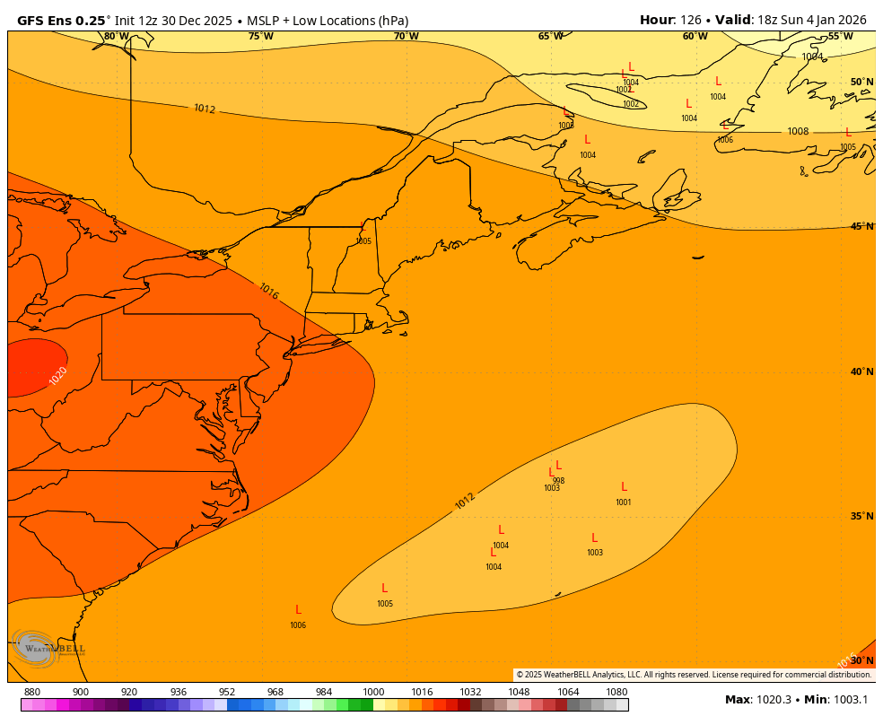
January 2026 regional war/obs/disco thread
Damage In Tolland replied to Baroclinic Zone's topic in New England
Seems like another decent event like tonight. Each one of these models have, lose and then pick back up as they get closer -

January 2026 regional war/obs/disco thread
ineedsnow replied to Baroclinic Zone's topic in New England
If we could get that northern stream to dive in a bit more it could make things interesting -
January 2026 regional war/obs/disco thread
ineedsnow replied to Baroclinic Zone's topic in New England
Probably.meh but models have been trending north a bit -
Another burst of snow coming through at home