All Activity
- Past hour
-
The 12z GEMLAM has 2 inches of rain over a large area. This is hour 45:
-
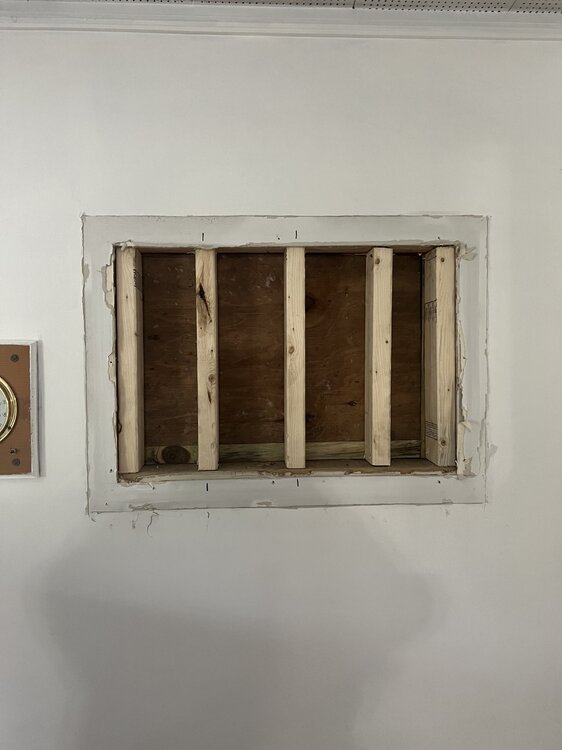
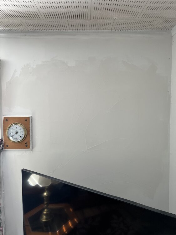
The one wall unit was uninstalled last week and went off to the landfill, Need to sand one more time then paint, The other 3 window units are going the same route but those never made it to the windows this year, Been leaving the windows partially open a few nights, One night it triggered the heat as the overnight low was in the 30's last week....................
-
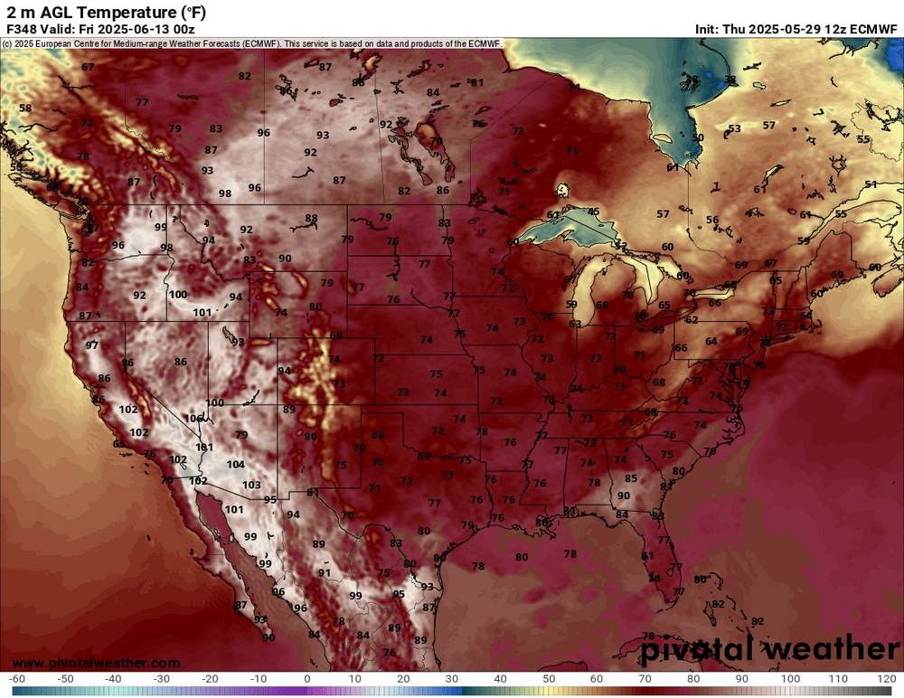
meh Euro is a few days near 80 here.. I think Thursday would be our best chance
-
western areas bake in the long range.. Thinking a more average Summer here while they fry...
-
80s for days We take!
-
this is the latest I've ever gone.. I could of used it one day but survived.. The fresh air has been great and pollen has been kept down by the rain
-
Remember when the forum had the excitement and gung-ho feeling about winter weather? Haha. Now we all high-fiving high pressure in the warm season.
-
No more installs after 06/5-6th, They'll be permanent.
-
until the next run and others are still meh.. I'll wait until this weekend to see if I install or not
-
Man we love to see that. Nothing extraordinary, but good June type weather.
-
AWT AMOUT Get em up and in ASAP
-
That's a summer look on the Euro. The cutoff is south enough to bring the warmer air into SNE. Installs by Tuesday.
-
I remember that day! I was at my sisters house and they were talking about it on the news with the active warning
-
Great Barrington Tornado?
-
Not sure if anyone (ahem @weatherwiz), 30 years ago today was eventful in New England
-

-
I’d probably be on the weather channel right now if not for the injury.
-
-
-
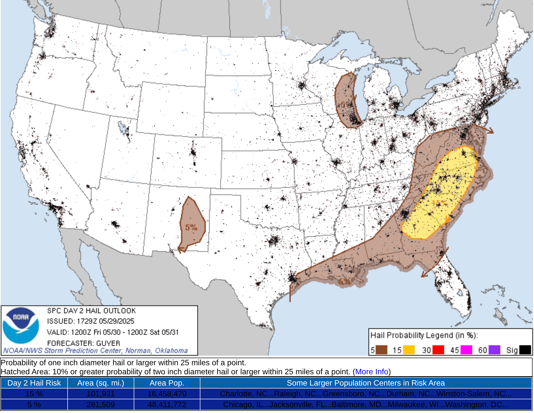
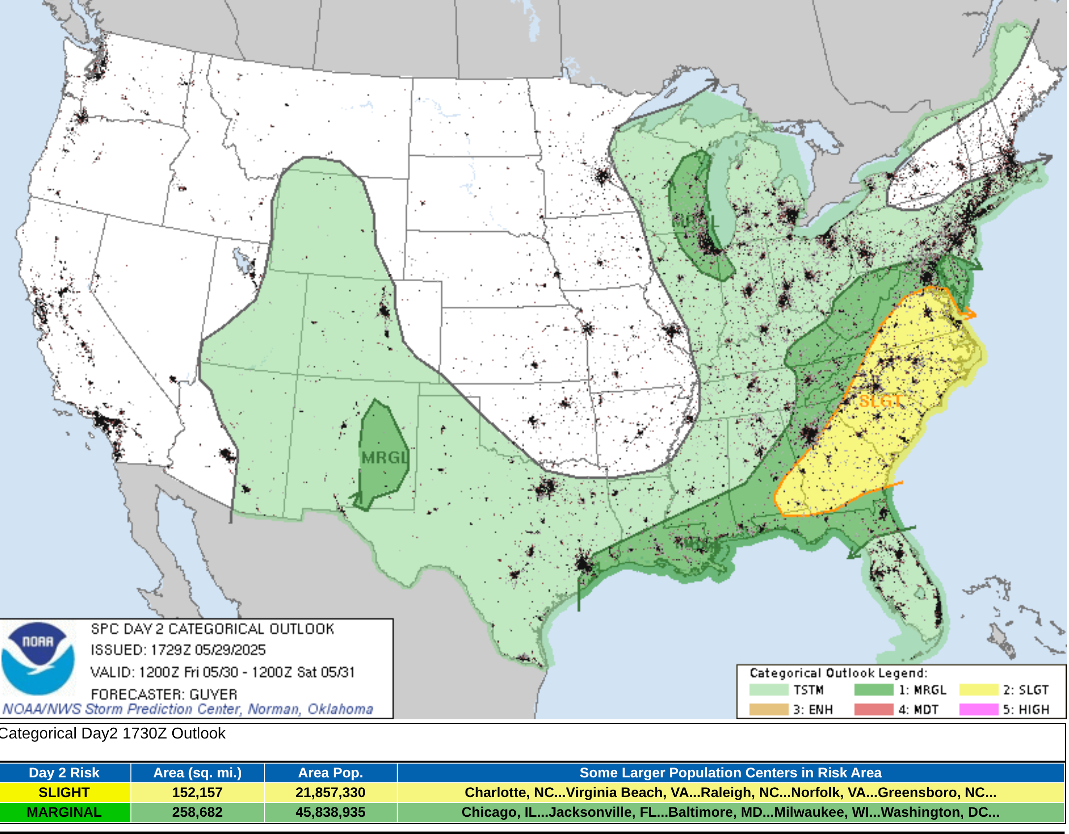
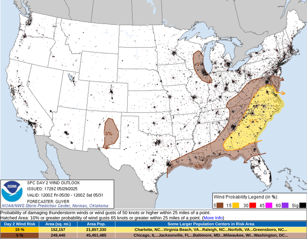
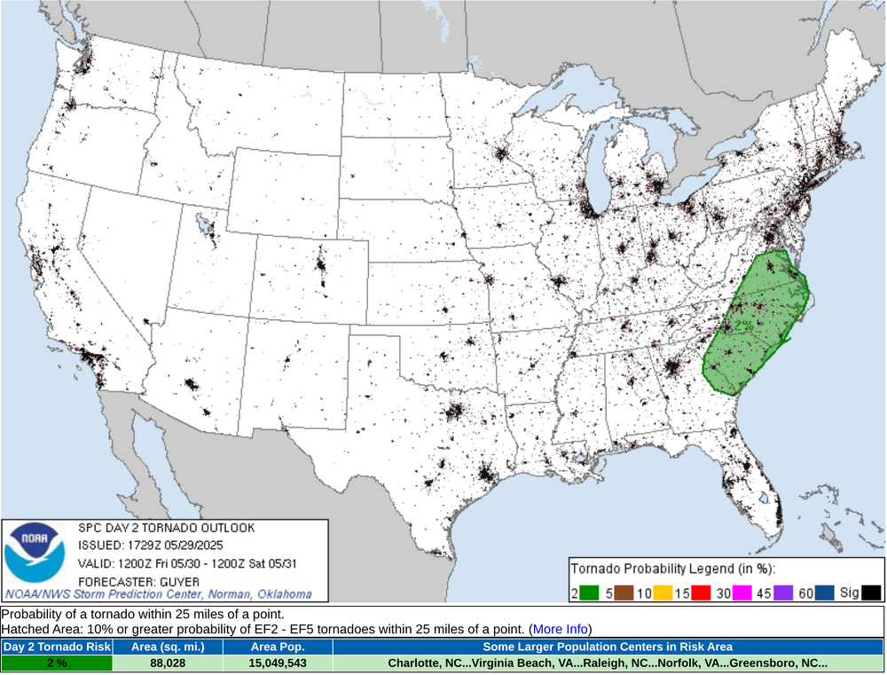
Here is the SPC forecast for May 30th, 2025 for Southeastern AL, FL Panhandle, GA, SC, NC, and VA with a potential upgrade in the severe potential SPC AC 291729 Day 2 Convective Outlook NWS Storm Prediction Center Norman OK 1229 PM CDT Thu May 29 2025 Valid 301200Z - 311200Z ...THERE IS A SLIGHT RISK OF SEVERE THUNDERSTORMS ACROSS THE CAROLINAS/MID-ATLANTIC/SOUTHEAST STATES... ...SUMMARY... Scattered severe storms with wind damage, large hail, and a couple tornadoes will be possible especially Friday afternoon and evening across the Mid-Atlantic/Southeast States. ...Carolinas/Mid-Atlantic/Southeast States... As large-scale pattern amplification occurs over the CONUS, a shortwave trough located over the lower Ohio River Valley early Friday morning, will steadily progress east-southeastward over the southern Appalachians and reach the Carolinas/Virginia by Friday evening. Strong winds aloft will accompany this shortwave trough with a belt of 60+ kt mid-level winds overspreading the southern Appalachians and Carolinas. While the warm sector preceding an east/southeastward-moving cold front will not be strongly unstable, particularly by late-spring standards, prevalent 60s F surface dewpoints, steepening mid-level lapse rates and strong deep-layer shear will support organized severe storms especially into Friday afternoon through early evening, including relatively fast-moving storms for late spring. While a few early day severe storms could occur across eastern Kentucky and nearby Allegheny Plateau/Appalachians, the main severe risk should begin to evolve in the immediate lee of the Appalachians including the Blue Ridge vicinity by Friday early/mid-afternoon. These storms, including some supercells and more prevalent evolving linear clusters with bowing segments, should reach coastal areas by early evening. Damaging winds and severe hail can be expected, and some tornado potential may exist as well, particularly across Virginia/North Carolina near the surface wave and warm front where low-level shear/SRH should maximize. ...Eastern Wisconsin/northern Illinois/Lake Michigan vicinity... A south/southeastward-digging clipper-type shortwave trough will influence the region into Friday afternoon and evening, with thunderstorms potentially focusing near a weak surface wave/instability gradient as a cold front otherwise progresses southward across the region. Low-level moisture will be rather modest with afternoon dewpoints generally limited to the lower 50s F. However, relatively steep lapse rates and moderately strong vertical shear, enhanced by 50+ northwesterly mid-level winds, should support strong/isolated severe storms Friday afternoon into evening, with hail and wind possible as storms progress south-southeastward. ...Eastern New Mexico... While the overall scenario will not be as severe storm-favorable as prior days, a couple of locally severe storms may occur Friday afternoon/early evening mainly near the higher terrain of east-central New Mexico. ..Guyer.. 05/29/2025

-

E PA/NJ/DE Spring 2025 Obs/Discussion
JTA66 replied to PhiEaglesfan712's topic in Philadelphia Region
M'eh, don't want to be in the bullseye this far out. Besides, the high is sliding off the coast, we quickly flip to rain. .75" from our latest storm, just under 10" for the month. 67F -
Just had my daily downpour a few minutes ago. I'd like a little sun for my tomatoes and to dry the ground a little.
-
Yay the sun has come out, bright and sunny here now
-
This 12z Euro run is the better fit for the present teleconnections ... not the the others. Just sayn'.
-
Maybe the rain hates you. How can we appreciate the sun if we don't have the rain? It irrigates the crops! It keeps things clean!