All Activity
- Past hour
-
Oh they'll be there.
-
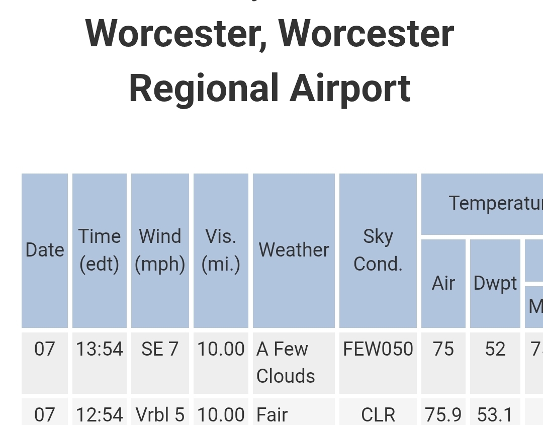
Pages 3&4: https://repository.library.noaa.gov/view/noaa/34048/noaa_34048_DS1.pdf
-
I caught something super nasty. Very sore and tickly throat, alternating between hot and chills, a bit of a stuffy nose, exhausted, feel unbalanced. Thought maybe covid but negative. I don’t get sick much (3rd time in 5 years) but wow…when I do it nails me.
-

2025 Spring/Summer Mountain Thread
Met1985 replied to Maggie Valley Steve's topic in Southeastern States
It poured the rain last night and has been raining today again. Very wet. -
Gimme a hell! Gimme a yeah! LFG
-
 The Euro has one of the strongest mid-August heatwaves we have seen. It has a Sunday to Sunday extended heatwave. Peaking on Wednesday at 102° in the usual NJ warm spots. So some spots will be near 40 days reaching 90° by the 17th. Euro NJ warm spots forecast Sun….93°….8-10 Mon….96° Tue…..99° Wed….102° Thurs..98° Fri…..94° Sat….95° Sun…95°….8-17 1944 stands as the strongest August heatwave during that period. Data for NEWARK LIBERTY INTL AP, NJ Click column heading to sort ascending, click again to sort descending. 1944-08-10 97 1944-08-11 102 1944-08-12 98 1944-08-13 100 1944-08-14 98 1944-08-15 99 1944-08-16 99 1944-08-17 95
 -

2025-2026 ENSO
Stormchaserchuck1 replied to 40/70 Benchmark's topic in Weather Forecasting and Discussion
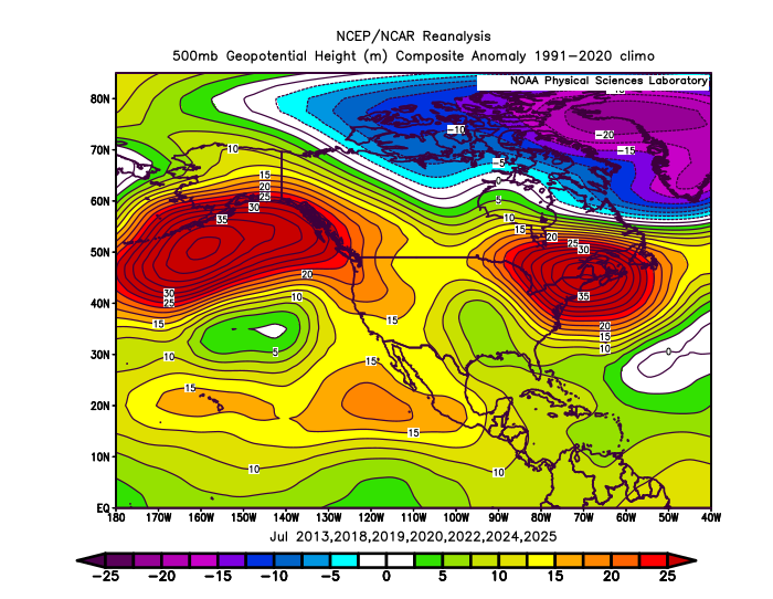
The 73-year average for PNA in July is a +0.2 temp correlation from ATL to NYC in +PNA vs -PNA, all data included. -
2025-2026 ENSO
Stormchaserchuck1 replied to 40/70 Benchmark's topic in Weather Forecasting and Discussion
Heatwave coming in France -
-
This summer has been complete trash for organized storms. No jet energy to speak of south of the Canadian border. The local heat islands / lake breeze convergence zones around Chicago and Detroit get some good afternoon stuff in an ultra-humid airmass with these weak fronts, but that’s about it. I’m hoping for something like 2018 where late August into September gets active again.
-
 That flooding that we had seems like a long time ago. It's gonna be rough next week with no rain to go along with the heat. I'm concerned about going into a drought in the coming weeks. This Euro run doesn't even give our area an inch of rain for the entire run. I hope it changes, but right now it looks like a very dry pattern. A lot of watering will be needed.
 -
OWD is an effing swamp. Home to one of the top 10 crappiest golf courses in America. Let's try another site where lots of people live and work.
-
 yeah very boring of late...and any tropical activity is still in fantasy range.
 -
Thankfully not very Dewey.
-
I'm down by the waterfront. Sorry you're sweating in Newton... shessh
-
 Weather has been nice but man it is boring as hell. I'd rather watch water evaporate. Soon to become hot and boring. It also looks to continue pretty dry. Lawn is crisping and garden needs regular watering. Missed out on any big rains here over the last several weeks. Hopefully in the next week to 10 days we'll have something meaningful to track in the tropics. Big ridge out there so westerly movement is favored over re-curvature OTS in the longer term.
 -
From smoke to FIYAHH! LFG!!
-
 Yeah and everything's quickly turning brown.
 -
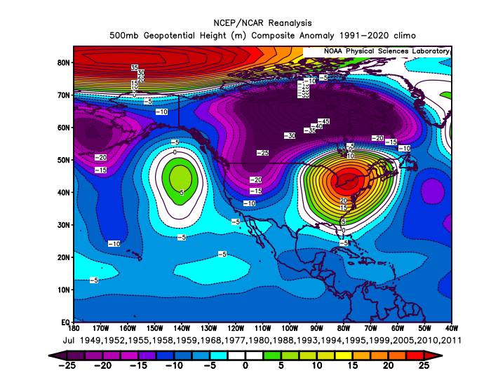
The tendency has been more +PNA in July since 2013 with a strong 500 mb ridge in the East. Prior to this recent decade we usually had more of a -PNA when there was a strong ridge in the East. Have also been seeing more ridging in the East during the winters in the 2020s with + PNAs than we used to in the past.
-
yeah-a hot dry stretch with limited if any precip even a half inch wouldn't do much with the warm/hot pattern
-
 155 mph hurricane straight into Jones Beach, 20 foot surge. I’d lock yourself up in the bunker now. And prepare your goodbyes, although everyone you say goodbye to is likely screwed too.
 -
Euro really keeps the heat going for a long time though. This run says the heat wave will last all the way through next weekend for my area.
-
In all seriousness, deep summer is about to make a comeback. The dog days are looking hot.
-
Euro's pretty straight forward.... you pick: do you want the heat, or do you want the hurricane. this rendition sends more heat. at least in the geopotential medium. not sure what the sfc/ 2-m stuff looks like but the AN is still evident above.
-
feels pretty warm.