All Activity
- Past hour
-

Septorcher 2026 Discussion - Endless Summer
butterfish55 replied to Damage In Tolland's topic in New England
Glad we don't live there. Wait, that's not true.... -

October Comes Early: Late September Multi-Hazard Hybrid Storm
dendrite replied to WxWatcher007's topic in New England
Pretty good back bent warm front and LLJ on the Rufus despite the low initially hooking west toward the Delmarva. Then it dumbbells back around toward the islands for round 2. -
Just one more reason to hate Ocean City!
-

October Comes Early: Late September Multi-Hazard Hybrid Storm
weatherwiz replied to WxWatcher007's topic in New England
Pretty stout LLJ. -

Strong Nor'Easter/Hybrid Storm Late September 2026
FPizz replied to Rjay's topic in New York City Metro
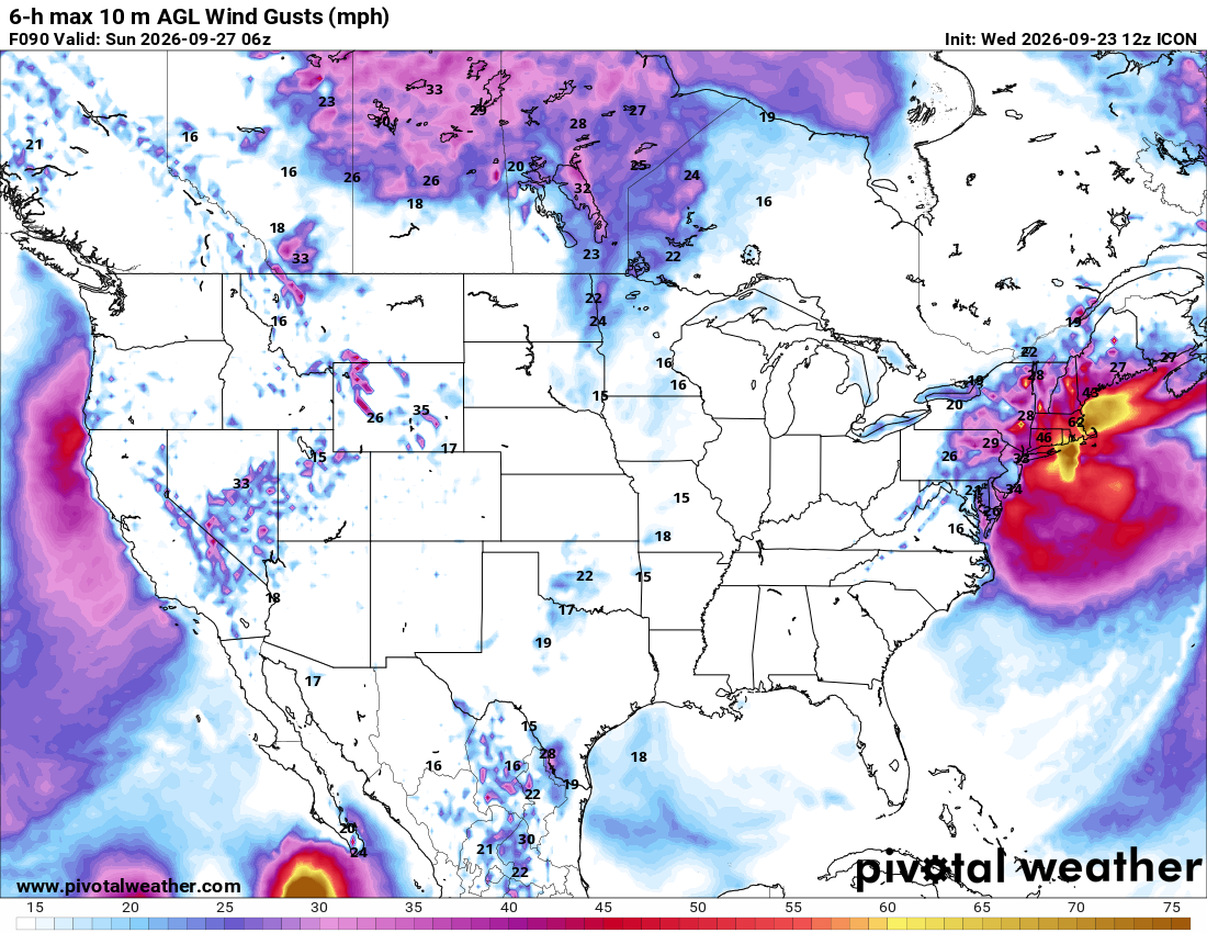
ICON $ shot -
 Man let’s lock that German run . Thats a ripper
 -
2016-17 was a weak Nina and short lived. ENSO was neutral by the beginning of Feb. My first Rehoboth beach blizzard chase was early Jan that winter, then the next one was early Jan 2018- the 'bomb cyclone'. Been 4 blizzards there in the last 10 years. Crazy.
-
 indian pharma network: GenIndusPharma - buy medication from india
 -
October Comes Early: Late September Multi-Hazard Hybrid Storm
dendrite replied to WxWatcher007's topic in New England
Yeah ICON is a doozy. RGEM is pretty far east, but wet enough to ruin the weekend. -
From the 11AM EDT advisory for TD 15E: ...INTERESTS IN THE HAWAIIAN ISLANDS SHOULD CLOSELY MONITOR THE PROGRESS OF THIS SYSTEM... SUMMARY OF 500 AM HST...1500 UTC...INFORMATION ---------------------------------------------- LOCATION...14.5N 154.4W ABOUT 320 MI...520 KM SSE OF SOUTH POINT HAWAII ABOUT 525 MI...840 KM SSE OF HONOLULU HAWAII MAXIMUM SUSTAINED WINDS...35 MPH...55 KM/H PRESENT MOVEMENT...WNW OR 290 DEGREES AT 6 MPH...9 KM/H MINIMUM CENTRAL PRESSURE...1004 MB...29.65 INCHES WATCHES AND WARNINGS -------------------- Interests in the Hawaiian Islands should closely monitor the progress of this system. A Hurricane or Tropical Storm Watch will likely be required for a portion of the state later today. —————————— The depression has slowed since the last advisory and seems to be moving west-northwestward at about 5 kt. A ridge to the northeast of Hawaii is forecast to weaken and slide eastward as a mid- latitude trough drops over the northwestern Hawaiian islands. This evolution is likely to the cause the cyclone to slow down later today or tonight and then turn northward or north- northeastward by tomorrow with some increase in forward speed. The trough is forecast to move westward this weekend as the ridge rebuilds north of Hawaii, which should force a sharp westward turn while the cyclone is close to the Big Island. At this time frame, it is impossible to know exactly when that turn will happen and, unsurprisingly, there is a large north-south spread in the guidance. Our best guidance is on the northern side of the track envelope, and new NHC forecast remains essentially the same as the last advisory. Interests in the Hawaiian Islands, especially on the Big Island, should closely monitor the system, with life-threatening catastrophic flooding possible over the steep terrain on this track. The depression should intensify slowly at first, given the current structure of the low-level center not co-located with the mid-level circulation as seen on satellite. However, after the system develops an inner core, the environment seems conducive for significant strengthening, with low shear, high mid-level moisture and SSTs from 28-29C. The rapid intensification probabilities are increasing, and the best model guidance is showing this as a major hurricane in a few days. Given the environment and the best-performing aids (Google DeepMind and HCCA) again showing major-hurricane strength, the NHC forecast is raised from the previous one and shows the cyclone as a major hurricane when it approaches the Big Island of Hawaii by the weekend. FORECAST POSITIONS AND MAX WINDS INIT 23/1500Z 14.5N 154.4W 30 KT 35 MPH 12H 24/0000Z 14.7N 155.2W 40 KT 45 MPH 24H 24/1200Z 15.0N 155.5W 50 KT 60 MPH 36H 25/0000Z 15.7N 155.2W 65 KT 75 MPH 48H 25/1200Z 16.7N 154.8W 80 KT 90 MPH 60H 26/0000Z 17.6N 154.5W 90 KT 105 MPH 72H 26/1200Z 18.2N 154.7W 100 KT 115 MPH 96H 27/1200Z 18.1N 157.0W 100 KT 115 MPH 120H 28/1200Z 18.7N 160.2W 95 KT 110 MPH $$ Forecaster Blake
-

October Comes Early: Late September Multi-Hazard Hybrid Storm
ineedsnow replied to WxWatcher007's topic in New England
@CoastalWx will like this run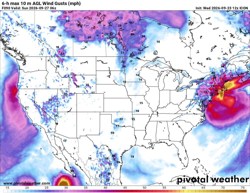
-
October Comes Early: Late September Multi-Hazard Hybrid Storm
ineedsnow replied to WxWatcher007's topic in New England
.thumb.png.50aceb0e9e202de29261f0469e0cbede.png)
-
Do you guys know there's a storm threaded for the noreaster?? Asking for a friend
-

October Comes Early: Late September Multi-Hazard Hybrid Storm
HIPPYVALLEY replied to WxWatcher007's topic in New England
Sign me up for that outcome. -
October Comes Early: Late September Multi-Hazard Hybrid Storm
ineedsnow replied to WxWatcher007's topic in New England
12z ICON and its members still pretty good.thumb.png.d119c659118bde174a704764f1fa38f4.png)
.thumb.png.2f3ed04b97ba8e69b8ad8cca14a4a07c.png)
-
October Comes Early: Late September Multi-Hazard Hybrid Storm
dendrite replied to WxWatcher007's topic in New England
It’s still coming west at 84hr, but yeah…not looking like a major impact that run. It’s better than 6z. Can’t trust the 12k nam past 6hr anyway. -
October Comes Early: Late September Multi-Hazard Hybrid Storm
weatherwiz replied to WxWatcher007's topic in New England
I think Oct. 6 unless its been pushed back again. -
58.3 here 2.82'' since late Monday,
-

October Comes Early: Late September Multi-Hazard Hybrid Storm
Brian5671 replied to WxWatcher007's topic in New England
When does it stop running? -
October Comes Early: Late September Multi-Hazard Hybrid Storm
Brian5671 replied to WxWatcher007's topic in New England
A complete miss lol -

2026-2027 Record-breaking El Nino
LakePaste25 replied to Stormchaserchuck1's topic in Weather Forecasting and Discussion
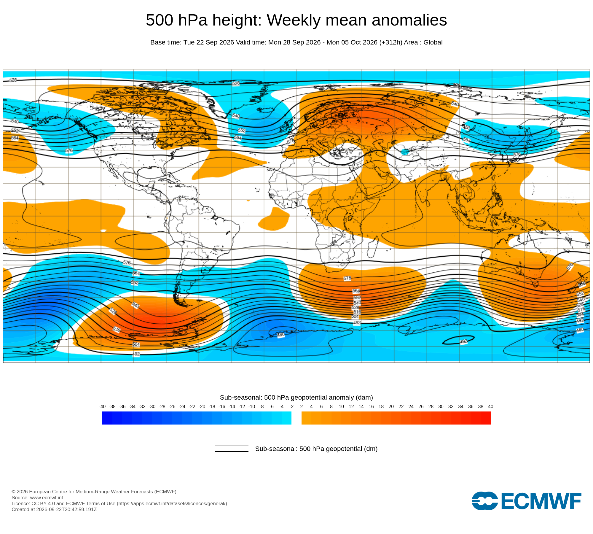
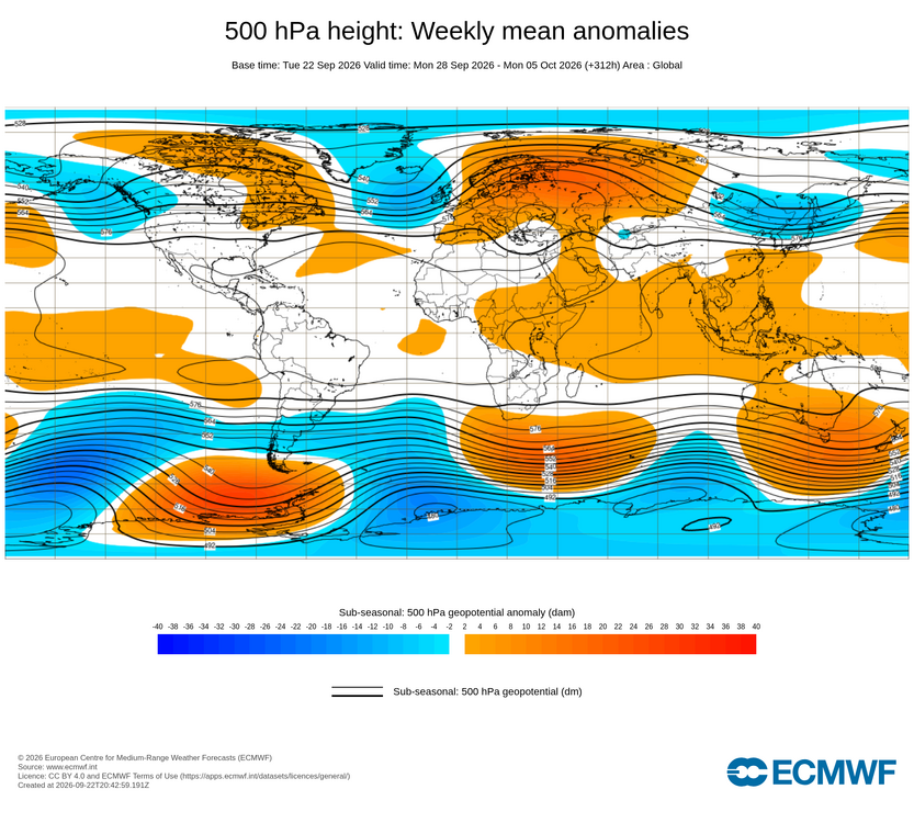
The +EPO is, but the H5 itself is not entirely cool ENSO flavored however, as the low is displaced SW will of BC into the GOA. -
October Comes Early: Late September Multi-Hazard Hybrid Storm
dendrite replied to WxWatcher007's topic in New England
50s/60s and rain? -

2026 C and E Pacific tropical activity
Boston Bulldog replied to GaWx's topic in Tropical Headquarters
Simultaneous major hurricanes named Nolo and Polo… surely the public won’t get confused lol -

2026-2027 Record-breaking El Nino
bluewave replied to Stormchaserchuck1's topic in Weather Forecasting and Discussion
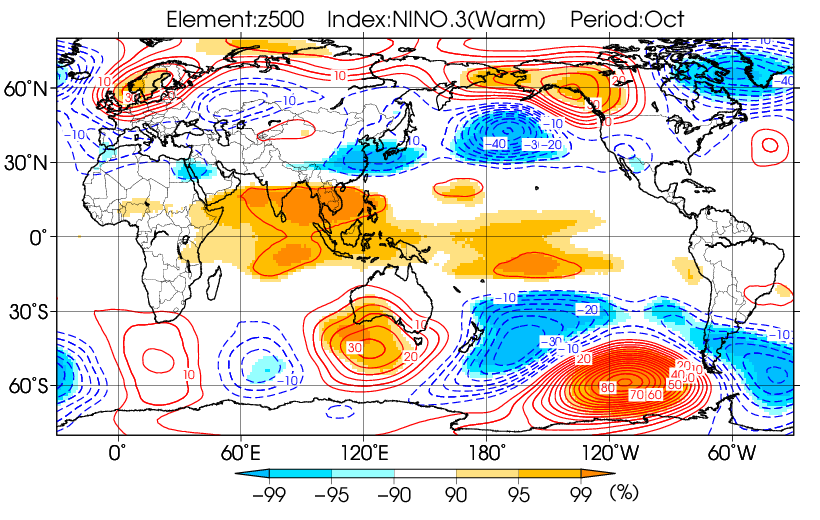
While we are still only getting a snapshot for the start of October, a +EPO is classic La Niña for October. We’ll see if heights can rebound a bit near Alaska which is more typical for El Niño. Still to early to tell where the ridge and trough locations finish for the entire month.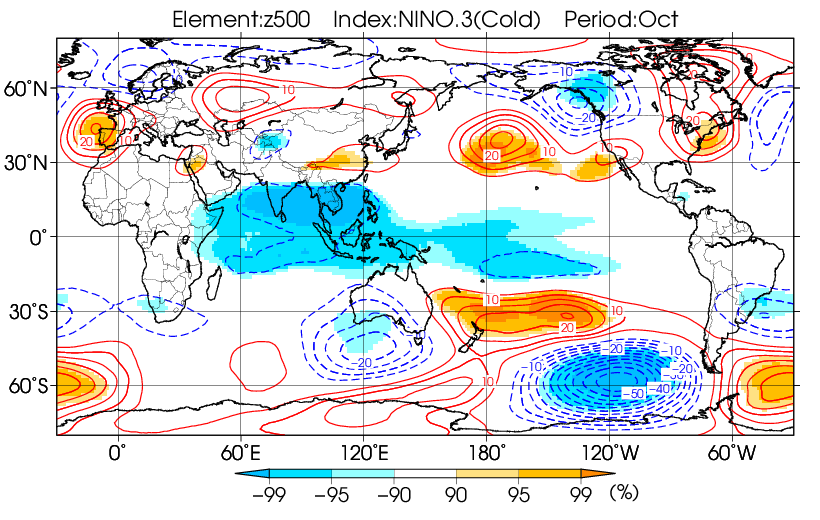








.png.9c965b5b49dc01900effd8af59b86e57.png)


.png.1c4d4bd04c731cdc88317567a0f06ab7.png)
.png.f812b82b515c03050056278a6cba459e.png)