All Activity
- Past hour
-
wow heck of a melt going on today for everyone. Was this forecasted?
-
The real test is how long does the sun today take to melt off the 1.7" of snow from yesterday evening on top of existing snow.
-
-
Not sure why so many are honking there. It’s different now vs even a month ago. There is a push or colder air but it’s not like this is an arctic front coming through. Seems like any ice chances are best near Kevin on north. It’s possible it could extend south but with the warmth today seems like more your typical glaze on trees vs road?
-
Yes any absorptive surface is really going to melt with the sun. Going to take a while for the pure white areas to ripen with this ice layer
-
 Seems to be a shortage of topics for my area. We identify as western New England for the most part anyway. Looking forward to the pre-St. Patty's Day torch. M40s today, L50s this weekend, L60s through next hump day. BRING IT ON!!
 -
I understand with a frigid antecedent airmass and cold surface temperatures there is a risk for ice. What I don’t understand with some of the colder depictions of this upcoming event that I’ve seen this morning on local TV is how would that occur? The surface and air are torched with cold trying to drain in? Seems like too much warmth to overcome. Can anyone enlighten me on why they are honking for another ice event down here?
-
Yeah some mixed signals for me though. Anyways whatever, not worrying at this point. It is what it is.
-
Talking right now. When the dogs start falling thru rather than walking on then we melt. Half my driveway is still ice over snow. Still have some of that inch that fell the other day on paths.
-
If sunshine is maximized with no clouds —as it is today—it does a lot of damage to the pack.
-
Of course we are…it’s still 12 plus days away. When are we ever sure on a 12-14 day prog? But the signs are good…that’s all we need to see at this stage. Actually that depiction that Ginxy posted shows a decent ridge position on the 500mb look EPS…maybe we can get it to spike a bit more over the next 12 plus days…
-
39.1° and deep blues. Drip baby drip.
-
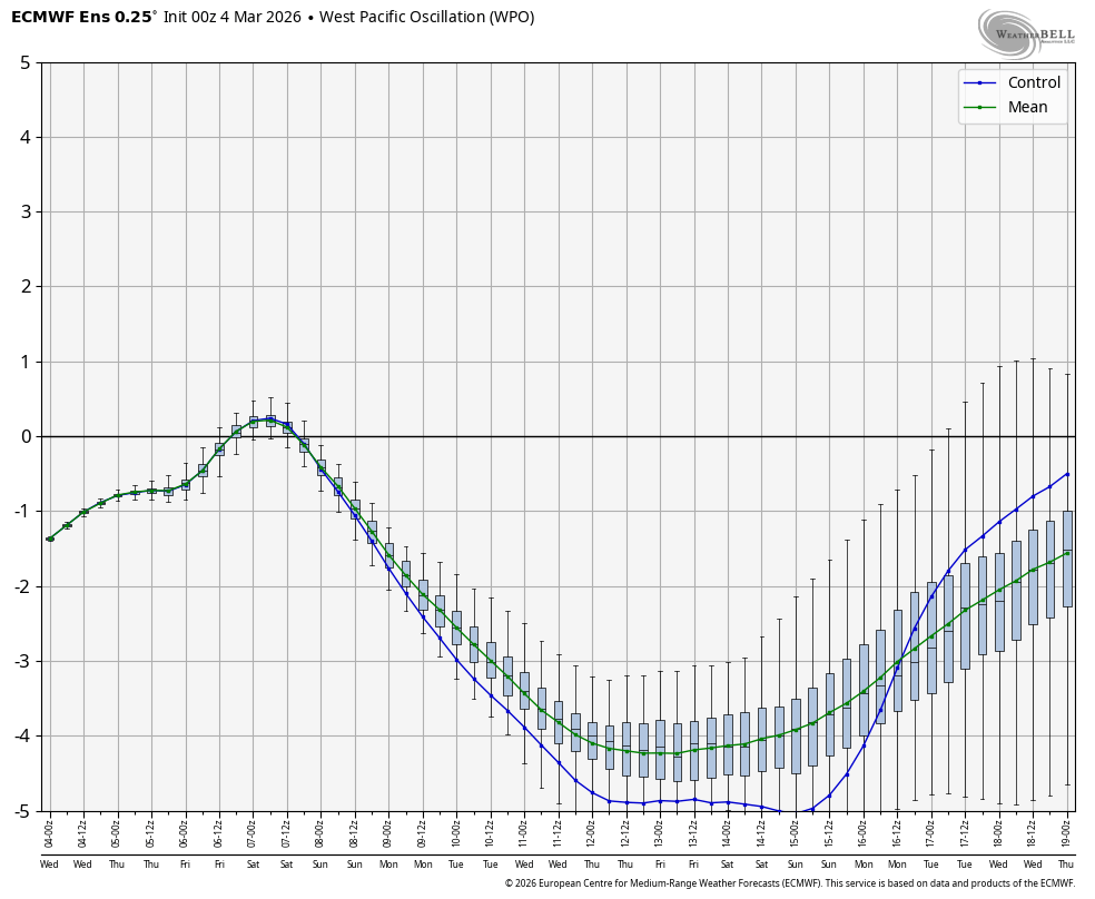
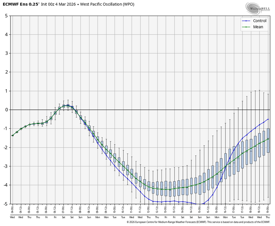
Upcoming -WPO punge is progged to be the lowest in March since March of 2017, when there were hard freezes all the way down to N FL and snow in the Carolinas:
-

Central PA Spring 2026 Discussion/Obs Thread
pasnownut replied to Voyager's topic in Upstate New York/Pennsylvania
and thats why I was happy with winter. We actually captitalized on a good period, and were able to hold the cold....and snow. Had that not happend, I'd be rather bummed and less "curvy" w/ my B+ grade. -
Oh, right... LOL That also reminds me, that December 2020 massacre.. I think some places lost 18" of pack in a single night. I guess maybe we can draw a distinction in "melt reasons" - if nerdy enough. heh. Like, if it's raining with 50 mph gusts at 55 F... you could decap Greenland with that. Kind of a different sport. This coming up will zephyr winds under sun with temps (maybe approaching 70) and DPs probably nearing 50 - who wins and how much
-
Absolutely... The old timers knew that... Some of new crews are just figuring that out...
-
it's gorgeous out honestly, was a mess earlier but everything falling with full sun and soaring temps.
-
Still unsure what mid month brings.
-
Clearly we are struggling with this inversion. Probably won't last the whole daylight. At some point, we see the temp surge 5-7 but everyone's at 10 am was struggling to touch 40 on a day that I feel pretty confident, if there were no snow pack, we'd already be in the mid or upper 40s heading for +3 to even 5 F MOS bust. This is sorta related to what Brian and I were just discussing. Unless you have a lot of mixing/turning over of the atmosphere, still boundary layers aren't really how to warm the air over a snow pack. That said, the DPs are rising with the temp. It's just 40/34 at FIT. This is the warmest DP ( I have seen ...) combined with above freezing air in months really. It may have happened ... but not with a post solar min intense Equinoxian sun. If we do burst into the upper 40s with DP say 38... water will be flowing from the fields.
-
I do that all year round Will be tough to top January 1996 for land-snow retreat rate.
-
Um yeah. 40 dews and low 50s temps.
-

2025-2026 New England Snow Recordkeeping Thread
512high replied to bristolri_wx's topic in New England
As of March 4, 2026 ASH> 68.25"+/- -
Yeah, perfectly stated.. I like the reasoning with the Oct sol comparison, too. I do that every day in my head in spring... 'today is Oct 8 sun' as an aside, part of me grins like ...why do that. I should just know at the scalar point what Mar 4 solar is, but for some reason, the autumn comparison helps. weird. Anyway, no problem slashin' T's there. I think the best part of that 10th and 11th will be watching perhaps the fastest land-snow retreat in history. heh
-
hoping the sun pops through here soon and clears the ice off the driveway
-
I feel like the AIs are hitting some theoretical ceiling if the surface was bare and dry. That would make sense given the sun angle equivalent in fall for Oct 5-10 where records are in the mid/upper 80s in the warm spots. But I think it’s safe to toss those readings. Slash 10°F off of those and you start getting closer to the op runs and highs from that 2/21/2018 record heat day.