All Activity
- Past hour
-

E PA/NJ/DE Autumn 2025 Obs/Discussion
Birds~69 replied to PhiEaglesfan712's topic in Philadelphia Region
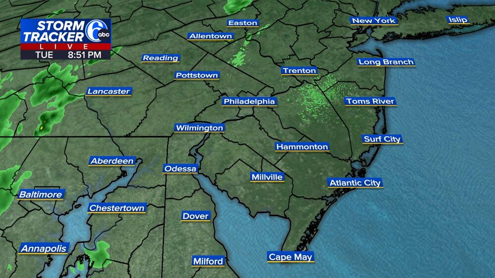
Moderate rain... -
Yeah I'm sure the NAM 3km is way overdone with the .75 to 1 inch for our area, but HRRR is probably underdone with the less than a quarter inch. Your prediction looks good -- probably close to a third of an inch. Obviously not enough to help with the drought, but I'll be happy to see the vegetable garden get a watering.
-
It was so nice today. Where did these clouds come from?
-
E PA/NJ/DE Autumn 2025 Obs/Discussion
Birds~69 replied to PhiEaglesfan712's topic in Philadelphia Region
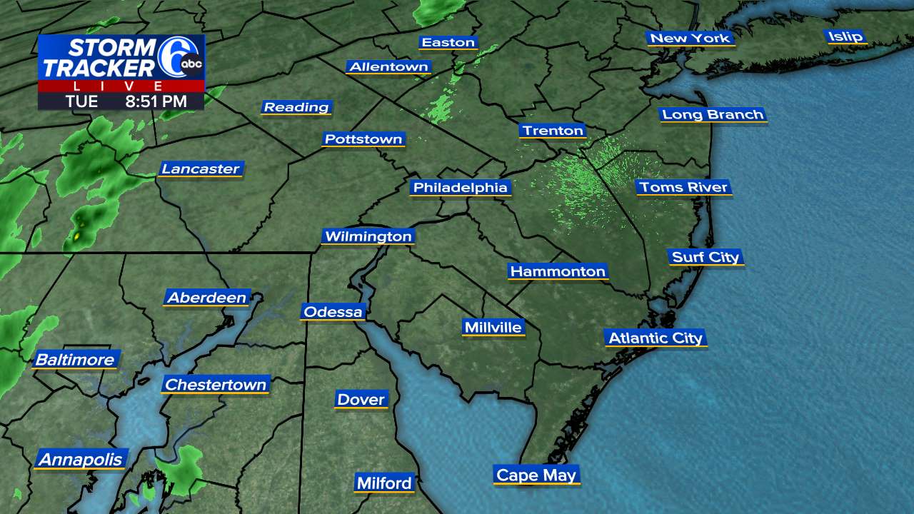
Heavier stuff just to the West with yellow and some oranges,..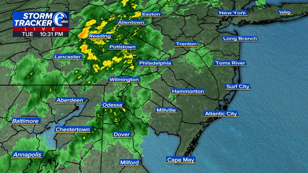
-
Yellow on. radar scope is moderate rain for sure. .01 in this part of Wantage so far.
-
That was a huge boomer at 8:45 that sounded like a big crash .
-
The extended products continue to depict a significantly +PNA and slightly -AO/NAO for the second week in Nov, with below normal temps for the east. Love me some chilly Fall weather.
-

E PA/NJ/DE Autumn 2025 Obs/Discussion
LVblizzard replied to PhiEaglesfan712's topic in Philadelphia Region
I was hanging out on my porch and was very surprised to see a lightning flash. Could be the last one we see all year as a fall/winter pattern looks like it will set in after this cold front passes. -
Last year we had to wait until the 3rd week of November to get below 40 and a week later to get below freezing.
-

Central PA Fall Discussions and Obs
canderson replied to ChescoWx's topic in Upstate New York/Pennsylvania
Nailed it. This is the few week of the year I never look at a forecast ha -

E PA/NJ/DE Autumn 2025 Obs/Discussion
Albedoman replied to PhiEaglesfan712's topic in Philadelphia Region
Just had a thundershower- light ---here in lower macungie -
Models have trended wetter for tonight and radar looks good. .25 to .5"
-

Central PA Fall Discussions and Obs
Itstrainingtime replied to ChescoWx's topic in Upstate New York/Pennsylvania
I wasn't following NWS today but MU was calling for showers between 5pm and 1am. -
Central PA Fall Discussions and Obs
Itstrainingtime replied to ChescoWx's topic in Upstate New York/Pennsylvania
Nice shower moving through here. About a tenth of an inch. -
Central PA Fall Discussions and Obs
canderson replied to ChescoWx's topic in Upstate New York/Pennsylvania
I was unaware there was a chance of rain tonight. -

Mid to long range discussion- 2025
WinstonSalemArlington replied to wncsnow's topic in Southeastern States
No more Warmth - Today
-

Spooky Season (October Disco Thread)
kdxken replied to Prismshine Productions's topic in New England
Good. Give it to New Hampshire. -
Mid to long range discussion- 2025
WinstonSalemArlington replied to wncsnow's topic in Southeastern States
-
+PNA and a sweet HL look. SE ridge crushed to oblivion. Non existent. It can happen! Lets hope it does when it really matters.
-
Saw some lightning to my SW, say toward Savage and Laurel just before 9pm. Overall a seemingly comparatively cool day IMColumbiaBY today with temps 64/43.
-
adding on to @Terpeast's message above for DCA and BWI... Snowfall @ IAD | DCA | BWI 1995-96: 61.9" | 46.0" | 62.5" 1996-97: 17.8" | 6.7" | 15.3" 2000-01: 12.9" | 7.4" | 8.7" 2008-09: 8.0" | 7.5" | 9.1" 2013-14: 52.8" | 32.0" | 39.0" 2021-22: 15.8" | 13.2" | 14.4" ----- Averages: IAD: 28.2" DCA: 18.8" BWI: 24.8" IAD minus 1995-96, 2013-14: 13.6" DCA minus 1995-96, 2013-14: 8.7" BWI minus 1995-96, 2013-14: 11.9"
-
another round of thunder and lighting incoming
-
No SE ridge linkage
-

Texas 2025 Discussion/Observations
Stx_Thunder replied to Stx_Thunder's topic in Central/Western States
Looks interesting this Friday - Saturday at least over the southern half, with a fairly stout incoming Pacific Low/trough axis into the state. Euro, GFS and ensembles had only really begun to latch onto a more deeper and more south-tracking system at the beginning of this week. So not 100% sold on it just yet. But the PNA has been (and still is) in a + phase. So this does bear some potential. Along with stronger storms and some kind of severe risk. Substantial rainfall amounts over a more drought-stricken TX now doesn't look very likely given its more likely progressive nature. But DL shear will at least be moderate. And this time, ML lapse rates will be steeper ahead of the system. Another big plus coming up is Fall looks to make an official statewide entrance next week before Halloween. The AO looks to go back into a negative phase while the AAO remains in a negative phase already. So below normal temps (even in STX) are not out of the question later next week. PNA is connected with the ENSO. Though as I've seen over the years, ENSO itself has a bigger, overall impact on TX. And, LN/cool phase ENSOs during winter have already been historically proven to be drier (and warmer) than normal for the most part. So I would not be surprised about record warmth (or even a few record-breaking, pre-frontal heat spikes in the southern half) at least in November and December. The pattern trend aloft so far this October has been quite similar to last October in 2024, with still, substantial influence from subtropical M-UL ridging nearby to our south still keeping things very warm for much of the state. The fly in the ointment is that the dynamical models are showing the ENSO (finally) heading back toward a warm phase or EN territory next Spring in 2026. If that is the case, then late winter - spring would more likely trend wetter and cooler overall with more SS jet influence over TX (instead of subtrop ridging). Which would also likely lead to a more active severe/MCS season in the upcoming spring. That pattern trend is what happened over the state more recently when EN started coming back in spring of 2015 and 2023. -
E PA/NJ/DE Autumn 2025 Obs/Discussion
Birds~69 replied to PhiEaglesfan712's topic in Philadelphia Region
Looks like stuff to the West will come in late tonight into the wee hours. A couple hours of showers. Still mild out there at 9:00 p.m., 61 F...