All Activity
- Past hour
-
I've turned a few on to those up here and they love them.
-

Central PA Summer 2025
Mount Joy Snowman replied to Voyager's topic in Upstate New York/Pennsylvania
Haha tell me about it. Normally we wouldn’t go out on a day like that but we had some friends in town from Alaska who really wanted to go on the boat. What’s nice about that long stretch of river is if you have RadarScope and a weather nerd on board you can pretty easily outrun any storms. But generally speaking, we wouldn’t typically be messing around in such conditions. -
Euro's been having increased run to run variability on details with this week. still, the ens are about at the ceiling for the means. I'm wondering if this doesn't have an extra special sauce with it and the models might or might not even see it - Oper Euro looks lagged/too cool on Monday - may be a mixing issue
-
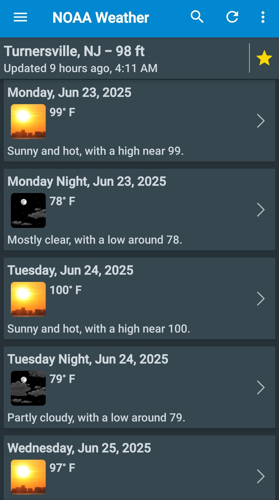
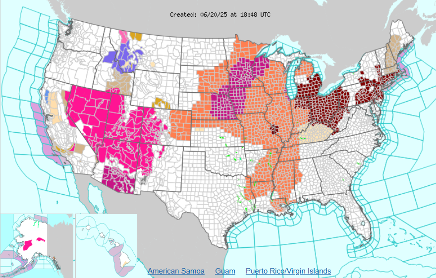
 Upton issued Extreme Heat Watch issued for most of the area, eastern Suffolk is left out. Is that different for an Excessive Heat Watch/Warning? Or did they just change the terminology? NWS has 100 forecasted for Mon and Tues. At least point and click in the Bx, a lot of Queens
 -
All these advisories for heat and here you have winter advisories in Montana and Idaho
-
-
 Tiko joined the community
 -
Still out but they say somewhere between 4-11 it will be restored. Kemp Mill and Takoma Park got hit really hard
-
https://nutwizard.com
-
MCS exiting Maine is classic backdoor scenario. Heat in jeopardy?
-
Euro has almost all of NYC and interior LI at 107° Tue. It looks overdone to me given the 850s. Looks like a lot of MU90s with a hundy here and there.
-
Definitely need a good canopy cleanse.
-
This is what I mean by a wetter atmosphere. From my own personal observations, it's made it harder to reach or exceed 100 and especially to get higher than 102 especially in the city and at the coast. Even without a seabreeze. In all our big heatwaves, like in 1993 and 1999, even in 2010 and 2011, I've seen clouds billow up as the temperature reached 100 or when it got into the lower 100s. Even on W or NW flow this tends to cut off the temperature rise. During the 30s, 40s, 50s, 60s, I deduce in our very hot summers there was less in the way of clouds and thats how NYC hit 106 in 1936 and how JFK hit 104 and LGA hit 107 in 1966. I know that 1966 was our driest year on record and no other year was even close.
-

Central & Eastern Pacific Thread
gallopinggertie replied to Windspeed's topic in Tropical Headquarters
Apparently, Erick beat the record for earliest-landfalling major hurricane in Mexico. And specifically, it beat the record for earliest-landfalling major on Mexico’s pacific coast by over two months! The next earliest was…August 26. -
It's much more logical to assume we needed lower heights to reach 100+ in the 30s, 40s, 50s, 60s, because the air was much drier back then. We got a taste of that in 2010.....
-
YES, 1936 redux!!
-
wild, so 2 99s in 1949, one in June and one in August, and one 98 in July Tony? and did the 3 100+ in a row in 1948 at JFK and NYC both happen in August Tony?
-
12z Euro AI still focuses highest heat over NJ intsead of sweeping it to the beaches. It also has a seabreeze for Monday.
-
Oh I know.. Keep expectations low and hope for a surprise..A metaphor for life in general I suppose
-
After a few mows they all seem to die off
-

E PA/NJ/DE Summer 2025 Obs/Discussion
BBasile replied to Hurricane Agnes's topic in Philadelphia Region
Yes, I cant wait!!
-
I can definitely see low 100s in the favored areas Monday and Tuesday... maybe Wednesday too
- Today
-
I liked your idea of a feeble kind of onshore wind unable to really cool beach/shore roads down much below 87 or so, while the baseball fields just inland have EMTs hauling heat victims away... (well, you didn't say that but I'm havin fun with it ) This could also be a great way to draw sharks closer to the Atlantic side swimmers, huh.
-
i have baby oak trees growing all over my lawn from last years acorns. I really don't want that again. i am actually kicking around the idea of taking down 3-4 big oaks in my yard. there will still be some, but those 3-4 trees make a ton of acorns and fall clean up is no joy with all those leaves.
-
Euro is a torch Wed-Thurs SoP. Bumped a bit warmer there. Still the same Sun-Tues. One of the days could have a weak seabreeze, more likely on Monday.
-
Major seabreeze on the 12z Euro for Monday, but Tuesday we go to 106 for a fairly large area