
All Activity
- Past hour
-

Augdewst 2026: Summer's Last Stand
dendrite replied to Prismshine Productions's topic in New England
Are we going to have to got through another fall of you injecting your winter predictions in every conflicting post you see? -
barry always gets the goods, chicago legend
-

super el nino banter thread
LakePaste25 replied to forkyfork's topic in Weather Forecasting and Discussion
snowman got too worked up over these people and let them get to him. It’s more fun to talk about warm anomalies and trigger them. Gotta roll with it. And the cool thing about it is we get brand new maps with red everywhere every other month, so I am constantly supplied with new material. -

Augdewst 2026: Summer's Last Stand
weatherwiz replied to Prismshine Productions's topic in New England
This isn't bad for D3. I'm not huge into these products but assessing everything you can see the potential is there and when you supplement with this product its certainly a real signal.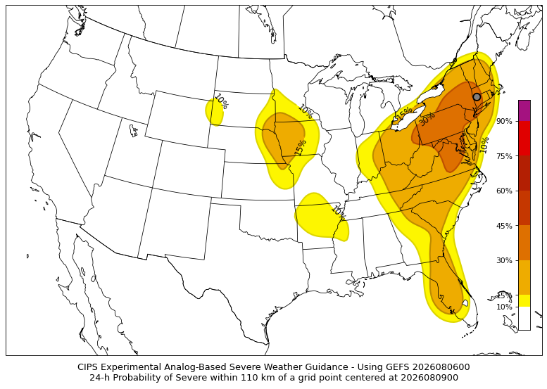
-

Augdewst 2026: Summer's Last Stand
40/70 Benchmark replied to Prismshine Productions's topic in New England
-
.thumb.gif.f92b16c631a1d15d405ed77b33f0710d.gif)
Augdewst 2026: Summer's Last Stand
Torch Tiger replied to Prismshine Productions's topic in New England
Yeah Saturday was the day, hopefully a few storms in a season devoid of them -

super el nino banter thread
A-L-E-K replied to forkyfork's topic in Weather Forecasting and Discussion
gotta keep posting -

super el nino banter thread
forkyfork replied to forkyfork's topic in Weather Forecasting and Discussion
this place became a climate change cope board about 10 years ago and most of the good posters left -

Winter 2026-2027 Seasonal Outlook
BooneWX replied to WinstonSalemArlington's topic in Southeastern States
I’m concerned about our source regions this winter. I think it may be really hard for Canada to not be torching but I hope I’m wrong. -
Humidity looks pretty relentless for the next 7 days.
-
Augdewst 2026: Summer's Last Stand
weatherwiz replied to Prismshine Productions's topic in New England
Saturday could be a pretty good widespread day of storms with some strong-to-severe storms -
 Viagra generic over the counter viagra without prescription - order viagra
 -

Augdewst 2026: Summer's Last Stand
SouthCoastMA replied to Prismshine Productions's topic in New England
Just hope for a roll of the dice KU this winter - with general snowfall expectations at basement level. -
el nino going nuclear gonna give us such a weird winter, expectations for snow obv low but hopefully the raging pac jet delivers some weird wild weather to keep things interesting
-
warm and rainy
-
Augdewst 2026: Summer's Last Stand
SouthCoastMA replied to Prismshine Productions's topic in New England
Looked that way down here earlier, but most of that faded. Just some normal cloudcover now, and looks to be breaking up a bit to our west.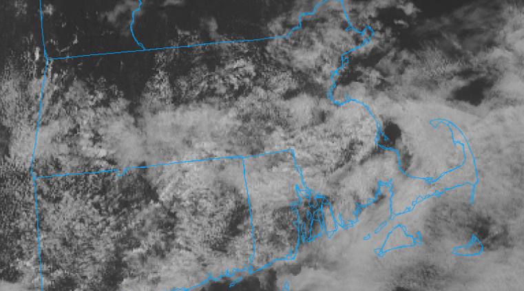
-
somewhat persistent lakes trough keeping things manageable for now but looks to weaken/slide east idk about 80 but he'll certainly have multiple mid to upper 70 dp days into august here
-

2026-2027 Record-breaking El Nino
PhiEaglesfan712 replied to Stormchaserchuck1's topic in Weather Forecasting and Discussion
To be fair, our last volcanic winter (post-Pinatubo) wasn't that severe. The period between 1991-96 was near normal temperaturewise, maybe a bit below normal. Once the 1997-98 el nino happened, things turned warmer permanently. -

Augdewst 2026: Summer's Last Stand
Brewbeer replied to Prismshine Productions's topic in New England
currently 77/75 in the 'hood, not a good day to work outside if you don't like being drenched in sweat -
Augdewst 2026: Summer's Last Stand
weatherwiz replied to Prismshine Productions's topic in New England
Won't have any time to dig into winter analysis but I really am curious how this winter will go. I do find it extremely hard to believe though this will not be a well above average for much of the U.S. With how expansive the 28-30C waters are (and still growing) expansive ridging is going to be too dominant. Hard to see anything really combating that. Probably be dealing with a raging jet too...but with that, maybe we get something and we benefit in a big way from a powerful jet -
(002).thumb.png.6e3d9d46bca5fe41aab7a74871dd8af8.png) Hey Mike, no problem. I went outside of Chester County to find "neighborhood" stations within 30 miles of Coatesville1SW with enough consistent overlapping observations from 1941-1975. We found 6 potential additional “neighborhood” stations but only 2 had enough consistent data Holtwood and Ephrata over the years in question to add to the 3 main Chester County stations above. So what did the analysis find? All 5 raw stations (Coateville 1SW / West Chester 2NW/ Phoenixivlle 1E / Holtwood and Ephrata move together at the same statistically same cooling rate for the same years from 1941-1975 so there is no inconsistent cooling or warming trend for the control station in this analysis (Coatesville 1SW) based on the raw data across these stations. However, as we have found before - the overall NCEI Adjusted Chester County data while following the raw average temperature pattern consistently applied a solid ~1-3 F post hoc adjustment to Coatesville 1SW and all of the 5 stations were chilled by NCEI lower than any of the 5 in the NCEI Chester County wide adjusted annual average temperatures. So for essentially the entire period! This was a clear offset, not a trend divergence. So again what station if not a neighboring station within 30 miles of Chester County was NCEI using to apply non-stop chilling adjustments to Coatsville 1SW to adjust the raw temperatures to even lower levels than they were all showing for all those years? So we know Coatesville 1SW was not adjusted cooler due to Time of Observation bias that was ruled out by majority 8am readings (if anything one could argue for a slight warming adjustment for homogenization) No station moves resulted in significant temperatures changes that were not statistically the same as the other area station trends so we still have no support for the individual Coatesville1SW chilling NCEI adjustments and no support for the overall Chester County historical 1941-1975 chilling adjustments made by NCEI.
Hey Mike, no problem. I went outside of Chester County to find "neighborhood" stations within 30 miles of Coatesville1SW with enough consistent overlapping observations from 1941-1975. We found 6 potential additional “neighborhood” stations but only 2 had enough consistent data Holtwood and Ephrata over the years in question to add to the 3 main Chester County stations above. So what did the analysis find? All 5 raw stations (Coateville 1SW / West Chester 2NW/ Phoenixivlle 1E / Holtwood and Ephrata move together at the same statistically same cooling rate for the same years from 1941-1975 so there is no inconsistent cooling or warming trend for the control station in this analysis (Coatesville 1SW) based on the raw data across these stations. However, as we have found before - the overall NCEI Adjusted Chester County data while following the raw average temperature pattern consistently applied a solid ~1-3 F post hoc adjustment to Coatesville 1SW and all of the 5 stations were chilled by NCEI lower than any of the 5 in the NCEI Chester County wide adjusted annual average temperatures. So for essentially the entire period! This was a clear offset, not a trend divergence. So again what station if not a neighboring station within 30 miles of Chester County was NCEI using to apply non-stop chilling adjustments to Coatsville 1SW to adjust the raw temperatures to even lower levels than they were all showing for all those years? So we know Coatesville 1SW was not adjusted cooler due to Time of Observation bias that was ruled out by majority 8am readings (if anything one could argue for a slight warming adjustment for homogenization) No station moves resulted in significant temperatures changes that were not statistically the same as the other area station trends so we still have no support for the individual Coatesville1SW chilling NCEI adjustments and no support for the overall Chester County historical 1941-1975 chilling adjustments made by NCEI. -
Augdewst 2026: Summer's Last Stand
dendrite replied to Prismshine Productions's topic in New England
Dude we’re trolling. Go back to working on your outlook. -

2026-2027 Record-breaking El Nino
FPizz replied to Stormchaserchuck1's topic in Weather Forecasting and Discussion
Yes, he is 100% making fun of all the X and bluesky posters being overly dramatic about everything -
The first 5 days of August only produced .28" of rain. The GFAF model gives Waynesboro a 55% chance of thunderstorms this afternoon between 3 - 6.
-
Augdewst 2026: Summer's Last Stand
40/70 Benchmark replied to Prismshine Productions's topic in New England
Okay.






