All Activity
- Past hour
-

Central PA Winter 25/26 Discussion and Obs
Summit Snow replied to MAG5035's topic in Upstate New York/Pennsylvania
Currently -7 and got down to -10. Brutal cold. -

Central PA Winter 25/26 Discussion and Obs
anotherman replied to MAG5035's topic in Upstate New York/Pennsylvania
-

The “I bring the mojo” Jan 30-Feb 1 potential winter storm
ADB83 replied to lilj4425's topic in Southeastern States
6z WN2. Definitely shifted south slightly. But pretty consistent run to run. Fascinated to see how it does. . -

Arctic Hounds Unleashed: Long Duration Late January Cold Snap
WxWatcher007 replied to WxWatcher007's topic in New England
-2.7 for a low here. Second consecutive morning below zero which hasn’t happened here since moving back to CT. -
They can't all be winners.
-

Possible coastal storm centered on Feb 1 2026.
40/70 Benchmark replied to Typhoon Tip's topic in New England
= You finally get 5PPD, which is still too many. -

Pittsburgh/Western PA WINTER ‘25/‘26
RitualOfTheTrout replied to Burghblizz's topic in Upstate New York/Pennsylvania
While we wait for the next threat, this is a pretty good read on what to expect for February: Also, never heard of this process before in the NWS discussion. I was curious why we were seeing light snow this morning. KEY MESSAGE 2... Low chances of flurries will continue through the next few days, likely maximizing each afternoon. This is because of incredibly efficient Burgeron-Fendisen processes in mixed phase clouds, making it very easy for any cloud to produce ice crystals. Each afternoon, this will be slightly enhanced by diurnal heating and destabilization, and the fact that the near-surface layer will peak into the DGZ with warming. -
Upton's morning AFD Regarding the potential for a coastal storm for this upcoming weekend, if any impacts were to occur it appears that the timing would be late Saturday night and into Sunday, and possibly Sunday evening for some eastern sections. Most of the dynamic modeling continues to show the storm being the nearest of misses, or, with the NYC metro not experiencing any snow impacts. The longwave pattern does amplify, but the mean eastern trough also begins to progress east while amplifying. A good rule of thumb is whether the 500 mb vorticity maximum or the 850 mb low gets north / south of Cape Hatteras. Just about all the dynamic and AI modeling has the vort max / 500 mb low going just south of Cape Hatteras. Climatologically that is a miss with respect to big snow for our area. In some cases far eastern areas get brushed. Therefore, at this point in the modeling / forecast process the most likely scenario is the nearest of misses. However, some impacts cannot be completely ruled out, especially further east as there remains some room for the modeling to wobble slightly further west which would bring eastern portions of the region in play for some minor to moderate impacts. Some coastal impacts remain a possibility in terms of minor coastal flooding. Stay tuned to subsequent forecasts for any changes.
-

1-30/2-1-26 Arctic Blast, ULL Snow Event
Holston_River_Rambler replied to John1122's topic in Tennessee Valley
Here are some 6z EPS .qpf spreads for select airport locations in east TN. -

Possible coastal storm centered on Feb 1 2026.
bristolri_wx replied to Typhoon Tip's topic in New England
I haven’t seen anything in the last 12 hours that leads me to believe that the forecast is locked in yet. It’s a large complex storm made of moving parts that in some cases haven’t formed yet. The low formation southeast of us is still oscillating to various degrees, which is leading to a wide variety of outcomes, even in the different scenarios that don’t lead to a large snowstorm for us. Impacts in western New England will be low, unless something dramatically changes. However central and eastern NE could be impacted heavily depending on today’s model output. Next 3-4 forecast cycles will probably become more consistent, especially as data sampling of the different parts improve. Most can make their decisions before bedtime this evening. -
I cant recall the last winter that was below average temps all months AND relatively dry. 2014/15 cold snowy 2013/14 cold snowy 2003/04 same Maybe a year in the 1970s?
-

Possible coastal storm centered on Feb 1 2026.
WeatherGeek2025 replied to Typhoon Tip's topic in New England
Let's see who here believes this comes back Emoji this comment = storm goes west and hits us crap = hits bahamas with 6-12 inches of snow -

The “I bring the mojo” Jan 30-Feb 1 potential winter storm
WiseWeather replied to lilj4425's topic in Southeastern States
We better hope it digs like a gopher . -

The “I bring the mojo” Jan 30-Feb 1 potential winter storm
lilj4425 replied to lilj4425's topic in Southeastern States
I want two feet. And where is Brick Tamland? -

The “I bring the mojo” Jan 30-Feb 1 potential winter storm
KChuck replied to lilj4425's topic in Southeastern States
Wonder what lilj4425 will complain about now??? -

Possible coastal storm centered on Feb 1 2026.
Damage In Tolland replied to Typhoon Tip's topic in New England
You’re assuming that’s correct -
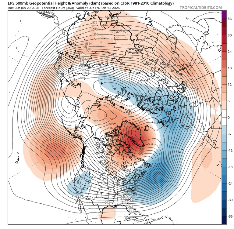
Block showing up on guidance.
-

Arctic Hounds Unleashed: Long Duration Late January Cold Snap
CoastalWx replied to WxWatcher007's topic in New England
Looks like some real cold tonight. -

Possible coastal storm centered on Feb 1 2026.
Kitz Craver replied to Typhoon Tip's topic in New England
Because it’s on a dead ass NE trajectory off of the Southeast Coast? -

Central PA Winter 25/26 Discussion and Obs
mahantango#1 replied to MAG5035's topic in Upstate New York/Pennsylvania
Since your home now, I think you can put your thong back in mothballs, as it is way too cold for that thing here. -

The “I bring the mojo” Jan 30-Feb 1 potential winter storm
PackGrad05 replied to lilj4425's topic in Southeastern States
I'd take 2" and be happy in southern wake. That's a solid snow here. -
For those that don’t know, Tom lives up on Roan Mtn. https://x.com/tomniziol/status/2016856004009332761?s=46&t=LVg8BRWCh1zZb6F_t95EVg https://x.com/tomniziol/status/2016856006039392447?s=46&t=LVg8BRWCh1zZb6F_t95EVg .
- 261 replies
-
- 1
-

-
- extreme cold
- snow
- (and 1 more)
-
1-30/2-1-26 Arctic Blast, ULL Snow Event
Holston_River_Rambler replied to John1122's topic in Tennessee Valley
I think it is an earlier generation of the AI models. I remember hearing about it more last year. But honestly not sure.- 261 replies
-
- 1
-
-
- extreme cold
- snow
- (and 1 more)
-

The “I bring the mojo” Jan 30-Feb 1 potential winter storm
Regan replied to lilj4425's topic in Southeastern States
3-6 is a lot more than we typically get… clearly I’d love 6. I am trying not to take these runs too exact. It’ll make you insane. -
I wish the trough was further west. Cold and dry look. Clippers?


