All Activity
- Past hour
-
A warming trend is now underway. Tomorrow should see temperatures top out in lower 80s and perhaps middle 80s. Friday and Saturday will be very warm days with highs in the upper 80s and lower 90s. Should Central Park reach 90°, 2026 would become the first year on record that New York City had a high of 80° or above in March and highs of 90° or above in April, May, and June. Saturday will remain warm before somewhat cooler air arrives to conclude the weekend. The ENSO Region 1+2 anomaly was +2.2°C and the Region 3.4 anomaly was +1.0°C for the week centered around May 27. For the past six weeks, the ENSO Region 1+2 anomaly has averaged +1.80°C and the ENSO Region 3.4 anomaly has averaged +0.90°C. The ongoing El Niño will continue to strengthen through the summer. The SOI was -34.80 today. The preliminary Arctic Oscillation (AO) was +1.384 today.
-
Finally got a solid storm (and hail that was appreciably small) today. My yard was due after all the storms spinning up all around me the last week or so.
-
Where's my invite?
-
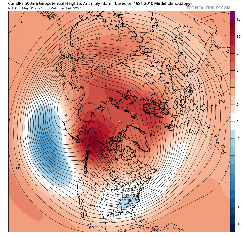
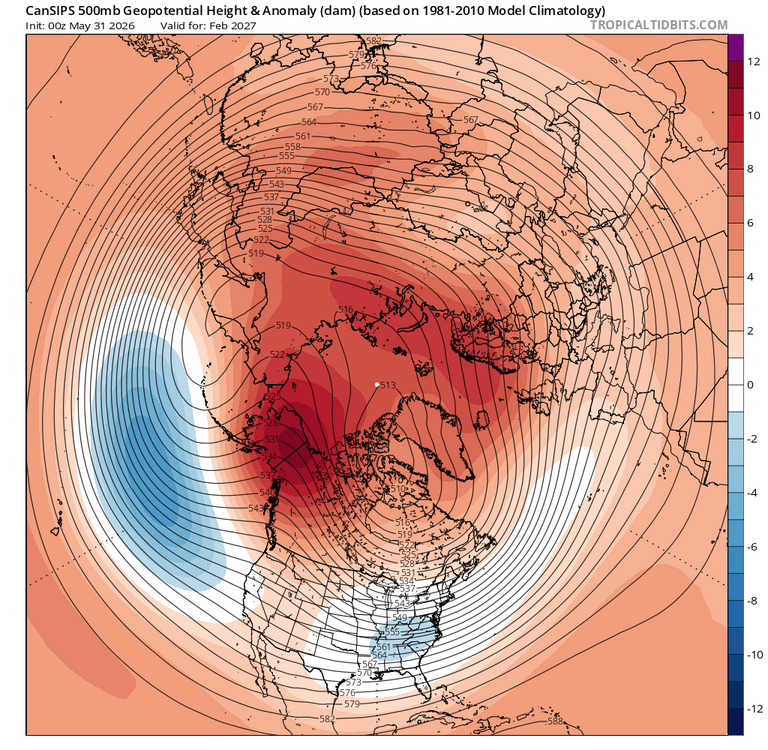
You didn't post h5 for Feb. The time for an east coast historic blizzard. +PNA, -EPO and -NAO.
-
it might be but this isn't
-

Junorch obs and discussion 2026
Damage In Tolland replied to Damage In Tolland's topic in New England
Well the NAM is discontinued -
Yeah... it's the yellow shit. I think that's pine ?
-
Getting hot for couple days this weekend and then quickly back into 70’s for highs. 2003 and 2015 prominent analogs
-
I'd watch for models to continue speeding up with the timing. There certainly could be a bit cutoff though within SNE where WOR is favored. Seeing the 18z NAM come in even quicker is something to watch...typically the NAM can be too slow.
-
Junorch obs and discussion 2026
Damage In Tolland replied to Damage In Tolland's topic in New England
Do a bit of research . I’ll assist
-
I see some very good signs analog outcome wise. Even a colder month 26-27 and more snow
-
Junorch obs and discussion 2026
Damage In Tolland replied to Damage In Tolland's topic in New England
There doesn’t look to be any convection with this and it’s all centered on Sunday morning to midday . SNE is just sunny and hot Saturday. NBM total qpf in SNE is very meh generally under .25 -
I would take today for the next 3 months. 85 and sunny. Perfect
-
It's not until around August 10th or so when sunset slips below 8pm that it's all that noticeable.
- Today
-
I've been thinking the over the last 2-3 days the potential would be more western/central NY and PA and maybe SNE Sunday. However, looks like Saturday may end up being centra/eastern NY and PA into SNE. There are still timing differences but the NAM seems to be speeding up a bit. Good wind shear and solid height falls. Would like to see higher dewpoints and mid-level lapse rates but that's more pertinent if you're looking for outbreak type stuff. Just looking for thunder/lightning and a shelf cloud. Anything beyond is a bonus
-
pines dumping pollen roundabout, way II track this stuff and it’s a week early .
-
Junorch obs and discussion 2026
Damage In Tolland replied to Damage In Tolland's topic in New England
Chase rain showers in NNE? -
 The thing is will that change stick or be yet another one off?
 -
Not sure how one can love summer yet hide in the AC from anything associated with it.
-

2026-2027 Strong/Super El Nino
snowman19 replied to Stormchaserchuck1's topic in Weather Forecasting and Discussion
-
Getting tingly about Saturday. Finally something to chase! What a boring week being off...nothing.
-
-
It’s summer. Love it. Breathe all of that green powder in. Max 81.3°
-
Hmmm... Meteorologist Ahmad Bajjey ordeonsSptl35ca7fc4lh6f7106413028f4t6g5u9a984m79fai3faif4l2m · This is going to be a bit of a read, but I want to draw your attention to something I've covered before. A little over a year ago, sweeping cuts to NOAA caused a large number of NWS locations to trim weather balloon launches either to 1 per day instead of the normal 2, or to remove launches completely. Upper-air data, the information collected by these, is the primary and overwhelming input factor into computer models. These go to everything from our forecasts, to NWS, to your app, to AI, etc. Model data fuels it all. Now, models are only as good as the data it ingests, and the more often or better the data, the more likely we can target a more accurate forecast. Notice I said more accurate, not perfect. We're not, but we do pretty darn well. Moving on. We started seeing data in models showing issues from a lack of input months ago, but I don't believe I've seen a NOAA office actually say it out loud until now. The Storm Prediction Center, the ones who are the best of the best when it comes to severe and destructive weather, creates all the daily severe weather outlooks, specifically stating they could not confirm an important part of the forecast because there was no measurement. No balloons over the Rockies or the plains this morning. Balloons launch at 0Z and 12Z each day, or they used to, and that lack of information not only affects the models but also the ability to create accurate forecasts. Kansas saw this exact issue to devastating effect this spring. We saw this issue when the northern MI ice storm showed horrible amounts of ice, and the amount was still more than any worst-case scenario model showed, as we lacked good input data from no launches in Green Bay and a single launch from Gaylord. Now, today, they all launched special 18Z balloons. Those happen on expected severe weather days. But these don't help morning or midday models, forecasts, or even aid in updating, as that is the usual window where storms may begin. Think of it like looking at a forecast, wherever that may be, and it saying to expect bad weather while it's already begun to hit. I say all of this because these are the facts. They're not pleasant, but the numbers don't lie; there is a measurable decline in model input and accuracy output. This affects every single forecaster, streamer, and app in the country. We all use the same info. And now a large agency has mentioned it directly. That's rather large weather news.
-
Junorch obs and discussion 2026
Damage In Tolland replied to Damage In Tolland's topic in New England
Imagine people that open windows in homes and cars with all this pollen . If they rubbed hands across window sill and floors below would be completely yellowed. Folks with window fans at night blowing it all over their faces and sheets. And car dashboards with enough folks can make letters and pictures with fingers in it . Not to mention breathing it all in.