All Activity
- Past hour
-

2026-2027 Super El Nino
donsutherland1 replied to Stormchaserchuck1's topic in Weather Forecasting and Discussion
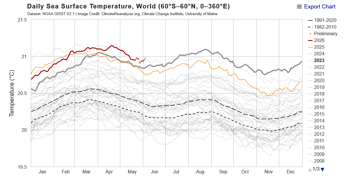
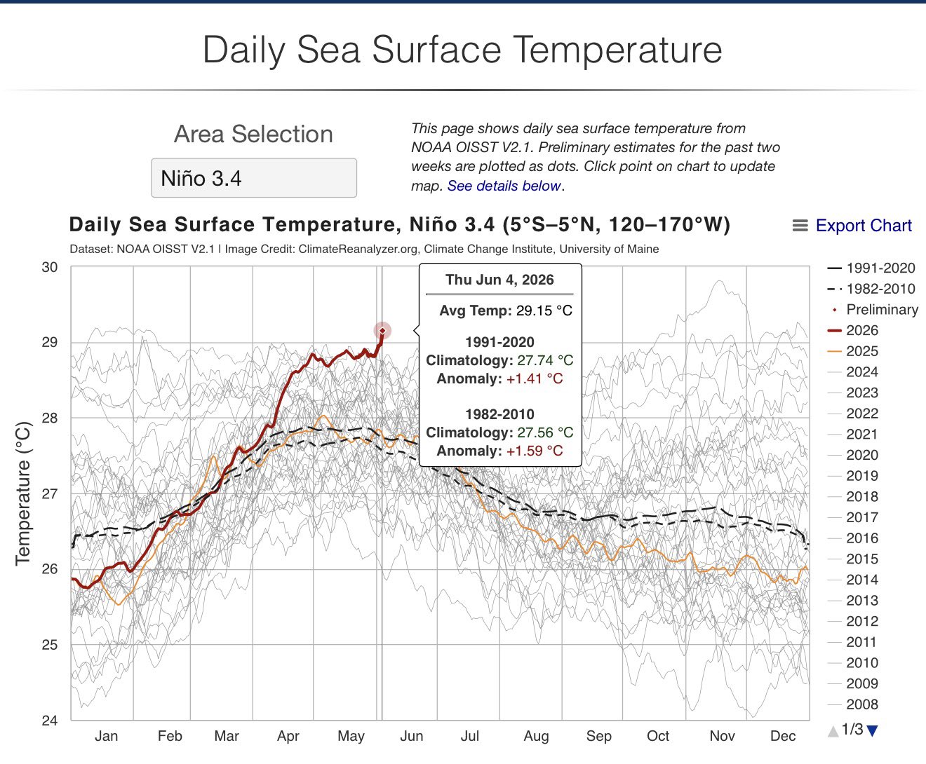
The ongoing and strengthening El Niño is already contributing to record warm ocean temperatures. Global sea surface temperatures are currently well ahead of those during the development of the 2023-24 El Niño.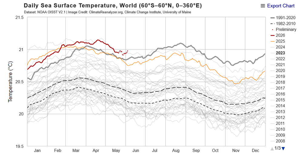
-
They'll just blame the Nino or use some other BS. These idiots can't be reasoned with.
-
That's going to change 2nd half of June. Ensembles are showing a much wetter pattern as early effects of the strong Nino begin to take hold.
-

Central PA Summer 2026 Discussion/Obs Thread
Mount Joy Snowman replied to Voyager's topic in Upstate New York/Pennsylvania
Low of 65, as the humidity creeps up. Already up to 78. Some nice mid summer-like weather ahead. Onward. -

Junorch obs and discussion 2026
Damage In Tolland replied to Damage In Tolland's topic in New England
Can’t even drop fert with no rain now. Blows -

-
 Just over 6" total here for MAM. Something needs to change.
 -
Congrats on storms later
-
(002).thumb.png.6e3d9d46bca5fe41aab7a74871dd8af8.png)
Central PA Summer 2026 Discussion/Obs Thread
ChescoWx replied to Voyager's topic in Upstate New York/Pennsylvania
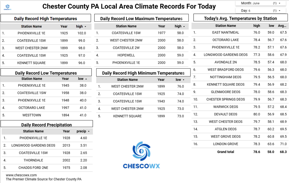
Today the PHL Airport looks to record a "heat wave" with their 3rd straight 90+ day. Here in Chesco most spots have not hit 90 degrees over the last few weeks, but we should see many spots do so today. There is a chance of some thunderstorms later this evening that would be welcomed as we continue to run dry across the region. A few degrees cooler tomorrow and several degrees cooler than that on Monday. We start another warming trend on Tuesday and could reach close to 90 degrees again by Thursday.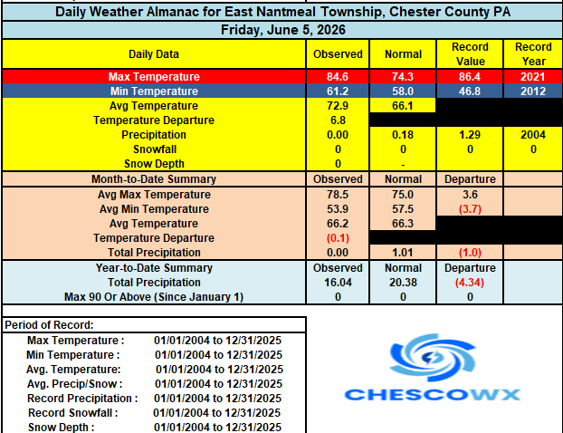
-
E PA/NJ/DE Spring 2026 Obs/Discussion
ChescoWx replied to PhiEaglesfan712's topic in Philadelphia Region
Today the PHL Airport looks to record a "heat wave" with their 3rd straight 90+ day. Here in Chesco most spots have not hit 90 degrees over the last few weeks, but we should see many spots do so today. There is a chance of some thunderstorms later this evening that would be welcomed as we continue to run dry across the region. A few degrees cooler tomorrow and several degrees cooler than that on Monday. We start another warming trend on Tuesday and could reach close to 90 degrees again by Thursday.
-
Very mild black fly period here, but the mosquitos are thick. Also, fireflies have arrived. This year makes 30 years since the worst black flies I've encountered. On Friday, 6/7/96, I was with 3 others at Oquossuc Bald Mountain scoping out a sno-mo trail, and I don't think we saw 10 black flies. The following Monday-Friday was our church's men's wilderness retreat, that year at Deboullie, about 25 miles SW from Fort Kent, and I predicted a modest black fly population. We drove to Portage Lake, got out at Coffin's store, and despite the high 80s (black flies tend to hide when it's hot) the area was thick with the little beasts. I slathered some Ben's 100 before launching our canoes at Pushineer Pond, and by the 75 minutes to reach the west end of Deboullie Pond where we would camp, the bug dope was no longer working. Another application lasted but an hour - Ben's usually is worth 5-6 hours; no way I would put that stuff on hourly. Next day when CAR hit the 90s, I was getting bombed while in the middle of the pond, 100+ yards from shore. (Not enough air space over land?) Only place to escape, other than the 100°+ temp sun-blasted tent, was in the rock crevices on the NW side of the pond, where there were still ice and snow. The black flies weren't interested where the temp was under 50.
-
What cold possibly go wrong? Think of Kevin's gypsy-moths.
-

2026-2027 Super El Nino
snowman19 replied to Stormchaserchuck1's topic in Weather Forecasting and Discussion
All time record-breaking anomalies of almost +8C showing up off the coast of Peru ^ “And again!!! Another day, another record for the current #ElNiñoCostero: the sea temperature anomaly measured in #Paita, #Piura yesterday was +7.9°C. Data @DHN_peru All of this, while all sea temperature indicators have skyrocketed in the last week. Not to mention the last month.” And a very pronounced (new) DWKW has formed in the WPAC from the current WWB wind stress: -
that has been the trend now for quite a while as we get closer and closer to game time the last several frontal passes - Upton says in the morning AFD "The main failure point with these storms is that the airmass has been so dry ahead of the front" .........one thing is for certain the drought will continue until further notice....
-
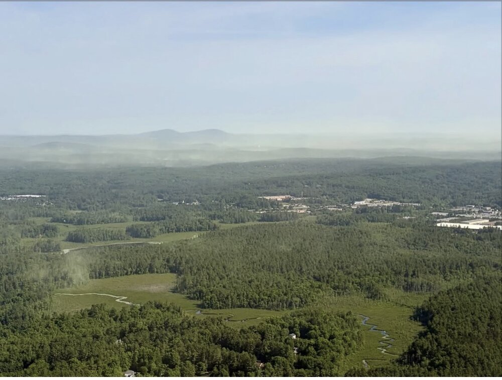
Southern NH. Post was yesterday, not sure when it was taken. Monadnock region
- Today
-

2026-2027 Super El Nino
forkyfork replied to Stormchaserchuck1's topic in Weather Forecasting and Discussion
muh backyard snow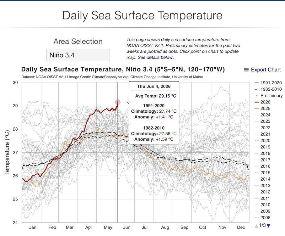
-
Both deer and horse suck the big one........I ithink deer are worse.
-
Junorch obs and discussion 2026
Damage In Tolland replied to Damage In Tolland's topic in New England
Because Stein. Foc’ing knew it
-
Hope mine is recommissioned in the next couple days to get it in later in the week.
-
Clouds ftl today. Why the eff has there been three days of cirrus?
-
Blah.
-
Nevermind…they arrived this morning.
-
Haven’t had many bugs at all but the skeeters are coming. We don’t have black flies here.
-
How are the mesos looking for storms? Flow screams marine layer stability as storms aproach the coast. .
-

Central PA Summer 2026 Discussion/Obs Thread
Voyager replied to Voyager's topic in Upstate New York/Pennsylvania
Impressive! A 30-44 percent chance of damaging winds. Will the Tamaqua Split® save the area or not. We shall see...