All Activity
- Past hour
-
Imelda has formed
-
I'm still not seeing anything in the recon plans regarding flying into Humberto. As far as I know/remember, they always fly into hurricanes within range, as Humberto clearly is.
-
Agree. I was surprised when I saw AI in their discussions earlier this year. I'd keep it "in house" for a few years to establish some kind of track record. So new and unproven. They mention Google but nothing about any of the other AI guidance available. I find that kind of odd as well.
-
Damp morning... Up to 0.57 for the morning....Good rebound for the month the last week or so...
-

September 2025 OBS-Discussion centered NYC subforum
SACRUS replied to wdrag's topic in New York City Metro
76 / 62 -
I have mixed opinions on the NHC utilizing DeepMind during the infancy of the AI revolution. It should absolutely be used as a tool, but Im not sure we are at the point where it should be used as a weighted metric in forecast discussions with the public. Model fatigue is a very real thing.
-

Potential Tropical Cyclone Nine
WxWatcher007 replied to WxWatcher007's topic in Tropical Headquarters
How about we keep the wishcasting and nonsense bust posting out of the thread? Recon just submitted a VDM. I think that should be enough for a designation at 11. Product: NOAA Vortex Message (URNT12 KWBC)Transmitted: 27th day of the month at 13:54ZAgency: National Oceanic and Atmospheric Administration (NOAA)Aircraft: Lockheed WP-3D Orion (Reg. Num. N42RF)Storm Number & Year: 09L in 2025Mission Identifier: Ptc09 (flight in the North Atlantic basin)Mission Number: 11Observation Number: 28 ( See all messages of this type for this mission. )A. Time of Center Fix: 27th day of the month at 13:04:10ZB. Center Fix Coordinates: 22.00N 76.00WB. Center Fix Location: 129 statute miles (208 km) to the ENE (71°) from Camagüey, Cuba.C. Minimum Height at Standard Level: 3,144m (10,315ft) at 700mbD. Minimum Sea Level Pressure: 1007mb (29.74 inHg)E. Dropsonde Surface Wind at Center: From 125° at 25kts (From the SE at 29mph)F. Eye Character: Not AvailableG. Eye Shape: Not AvailableH. Estimated (by SFMR or visually) Maximum Surface Wind Inbound: Not AvailableI. Location & Time of the Estimated Maximum Surface Wind Inbound (Undecoded): NAJ. Maximum Flight Level Wind Inbound: From 146° at 27kts (From between the SE and SSE at 31.1mph)K. Location & Time of the Maximum Flight Level Wind Inbound: 8 nautical miles to the SE (135°) of center fix at 13:02:18ZL. Estimated (by SFMR or visually) Maximum Surface Wind Outbound: Not AvailableM. Location & Time of the Estimated Maximum Surface Wind Outbound (Undecoded): NAN. Maximum Flight Level Wind Outbound: From 40° at 25kts (From the NE at 28.8mph)O. Location & Time of the Maximum Flight Level Wind Outbound: 16 nautical miles (18 statute miles) to the NW (314°) of center fix at 13:08:03ZP. Maximum Flight Level Temp & Pressure Altitude Outside Eye: 10°C (50°F) at a pressure alt. of 3,056m (10,026ft)Q. Maximum Flight Level Temp & Pressure Altitude Inside Eye: 11°C (52°F) at a pressure alt. of 3,058m (10,033ft)R. Dewpoint Temp (collected at same location as temp inside eye): 12°C (54°F)R. Sea Surface Temp (collected at same location as temp inside eye): Not AvailableS. Fix Determined By: Penetration, Wind, Pressure and TemperatureS. Fix Level: 700mbT. Navigational Fix Accuracy: 0.01 nautical milesT. Meteorological Accuracy: 1.5 nautical milesRemarks Section: Maximum Flight Level Wind: 27kts (~ 31.1mph) which was observed 8 nautical miles to the SE (135°) from the flight level center at 13:02:18Z -
That's what im saying. Its a fish storm.
-
it's black walnut season

-
Another bust. The rain this morning is now more exciting than this system. Might as well close the thread.
-
Potential Tropical Cyclone Nine
WxWatcher007 replied to WxWatcher007's topic in Tropical Headquarters
And should that happen, the longitude of future Imelda will be key to whether this gets steered back to the coast or merely meanders until the trough eventually arrives to kick it into the North Atlantic. Like @donsutherland1 I’m skeptical of it getting steered back west right now but it’s on the table. -
The more I hear about this SAI index, the more questionable it sounds. But as for the northeast Pacific, I agree it will probably continue to cool given the storm track. It could always reverse later of course, but I see no sign of that through October at least.
-

September 2025 OBS-Discussion centered NYC subforum
donsutherland1 replied to wdrag's topic in New York City Metro
The guidance still has the showers/light rain. Whether they're correct remains to be seen. -
The last frame of 6Z Euro has this stop its ENE movement and then suddenly drift back due W fwiw as Humberto accelerates away and the upper high builds enough to its N to change the steering. Although this is the only major op doing this, 40% of the 6Z EPS do not escape and most of those stall not too far offshore and then attain a W component of motion.
-

Potential Tropical Cyclone Nine
Kevin Reilly replied to WxWatcher007's topic in Tropical Headquarters
Yea this looks like a depression now or by 11 am as you said. Humberto is pretty far away east from this system. It’s obvious that Humberto turns out to sea gotta wait to see how high pressure builds into the Northeast and Mid Atlantic to put the block in place to initiate movement towards South Carolina, then the stall of Imelda, followed by the bounce off the high to the north and deflection out to sea. Pretty simply put all about exact timing of players build and strength. -
I say bring it. We definitely need some good rain here in Eastern PA.
-

E PA/NJ/DE Autumn 2025 Obs/Discussion
PhiEaglesfan712 replied to PhiEaglesfan712's topic in Philadelphia Region
Today is the 40th anniversary of Hurricane Gloria: This was as bad as Sandy, maybe even worse. -
Another bust and OTS she goes.
- Today
-
Potential Tropical Cyclone Nine
WxWatcher007 replied to WxWatcher007's topic in Tropical Headquarters
It looks like there may be enough of a wind shift to designate this at 11am. -
Potential Tropical Cyclone Nine
Kevin Reilly replied to WxWatcher007's topic in Tropical Headquarters
Looks like a center is going to form just north of Cuba on the north Cuban Coast / south of the Bahamas and lift north bound. -
Well this mornings GFS has snow for those visiting on Columbus Day weekend. At least if the foliage is gone they’ll have something to look at!
-
Days are getting shorter, nights are getting colder, who knows what weathers in order... One thing is guaranteed, however, its Spooky Season! Sent from my SM-S166V using Tapatalk
-

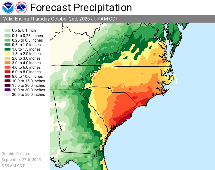
2025-2026 Fall/Winter Mountain Thread
Maggie Valley Steve replied to Buckethead's topic in Southeastern States
Morning Update from the WPC regarding excessive rainfall and amounts.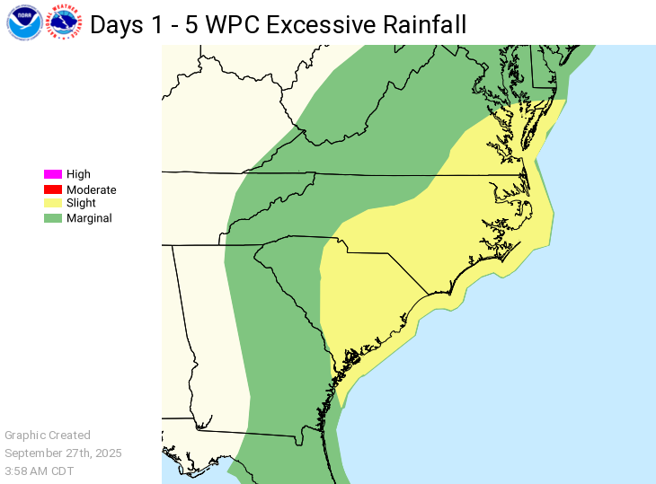
-
Potential Tropical Cyclone Nine
WxWatcher007 replied to WxWatcher007's topic in Tropical Headquarters
SHIPS has some decent odds of RI occurring relative to climo. Maybe something to watch as the organizational trend continues today. -

September 2025 OBS-Discussion centered NYC subforum
Sundog replied to wdrag's topic in New York City Metro
Maybe some light rain overnight? Who knows, you can't trust models 12 hours out anymore.
.thumb.jpg.5af6c8520bd26ab0d13e24b2747484e1.jpg)