All Activity
- Past hour
-
Well 22” is the big stuff. Very Near and over 30” is the real insane stuff. Ya, 22” is great.
-

Feb 10-11 Mid Week Minor Event - Ride the hot hand?
CoastalWx replied to HoarfrostHubb's topic in New England
It’s just very light here. Hippy’s ob is a little concerning. -

Feb 10-11 Mid Week Minor Event - Ride the hot hand?
wxsniss replied to HoarfrostHubb's topic in New England
Near Fenway: Nice moderate snowfall with great dendrites for 20 min with that band earlier, put down a fresh coating Radar looking not meager over eastern NY, expecting ~2-3" here -

Feb 10-11 Mid Week Minor Event - Ride the hot hand?
JACKASS replied to HoarfrostHubb's topic in New England
Wasn't that your forecast? Or were you going 2-4? -

Winter 2025-26 Medium/Long Range Discussion
michsnowfreak replied to michsnowfreak's topic in Lakes/Ohio Valley
Deep Winter? Yes. Snow? No. -

Feb 10-11 Mid Week Minor Event - Ride the hot hand?
dendrite replied to HoarfrostHubb's topic in New England
Some of the models had some dry air south of rt 2. This would be deep enough that it’s not entirely a valley issue.
-

Feb 10-11 Mid Week Minor Event - Ride the hot hand?
ineedsnow replied to HoarfrostHubb's topic in New England
so glad to be out of there.. not sure how I made it so long. -

Feb 10-11 Mid Week Minor Event - Ride the hot hand?
DavisStraight replied to HoarfrostHubb's topic in New England
You will soon -

Feb 10-11 Mid Week Minor Event - Ride the hot hand?
mahk_webstah replied to HoarfrostHubb's topic in New England
Looks like we get the 7-10 split -
DTW soared to 45° today with sun. First time over freezing in 3 weeks. Snow depth went from 8" to 5" and should glaciate as temps drop below freezing tonight.
-
2 towns over. Was still happy with 22.
-
.thumb.png.4150b06c63a21f61052e47a612bf1818.png)
Feb 10-11 Mid Week Minor Event - Ride the hot hand?
HIPPYVALLEY replied to HoarfrostHubb's topic in New England
Yeah, maybe? Not sure. Frustrating. -

Feb 10-11 Mid Week Minor Event - Ride the hot hand?
Damage In Tolland replied to HoarfrostHubb's topic in New England
Scooter closing in on an inch in S Wey . That’s a valley issue tonight . Hills and coasts -

Feb 10-11 Mid Week Minor Event - Ride the hot hand?
Great Snow 1717 replied to HoarfrostHubb's topic in New England
A bit of sleet mixing in at times in Methuen -

2025-2026 Fall/Winter Mountain Thread
NCBlizzard replied to Buckethead's topic in Southeastern States
Thanks for the insight. I'm pumped to get a spot and have a lot less frustration due to the lack of snow in the Piedmont haha. Cheers! -
Feb 10-11 Mid Week Minor Event - Ride the hot hand?
ineedsnow replied to HoarfrostHubb's topic in New England
dry air moving up the valley? light to mod snow here -

Feb 10-11 Mid Week Minor Event - Ride the hot hand?
DomNH replied to HoarfrostHubb's topic in New England
Sounds like we might be mixing with a little IP or snow grains. -

Feb 10-11 Mid Week Minor Event - Ride the hot hand?
dryslot replied to HoarfrostHubb's topic in New England
First flakes here now, 27/17°F. -
Feb 10-11 Mid Week Minor Event - Ride the hot hand?
HIPPYVALLEY replied to HoarfrostHubb's topic in New England
I’m approximately where that red dot is and don’t even have a stray flake falling here.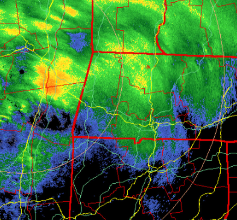
-

Feb 10-11 Mid Week Minor Event - Ride the hot hand?
ORH_wxman replied to HoarfrostHubb's topic in New England
Looks like we may get a decent shot for a couple hours later this evening.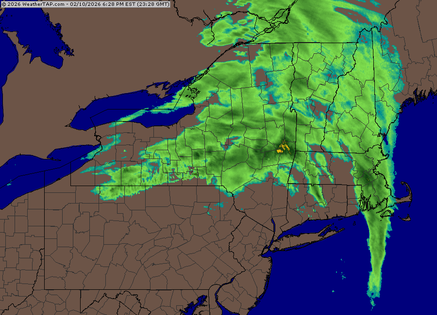
-
Feb 10-11 Mid Week Minor Event - Ride the hot hand?
CoastalWx replied to HoarfrostHubb's topic in New England
Few flakes. Almost half inch. -
ME!!!!!! I yearn for an 75° evening, active bass after an afternoon pop up storm, my choice of fly rod or baitcaster, a packed lip and a beer. Let’s go!
-
Feb 10-11 Mid Week Minor Event - Ride the hot hand?
DavisStraight replied to HoarfrostHubb's topic in New England
Just started here. -

Winter 2025-2026 Offers Return to Normalcy
40/70 Benchmark replied to 40/70 Benchmark's topic in New England
Close Call President's Day With Warm Up Thereafter Major Storm Expected To Remain Largely At Sea Expected Pacific Onslaught Likely Prohibitive Eastern Mass Weather forecast the development of a fairly strong -PNA pattern for the month of February in the Eastern Mass Weather winter outlook issued last fall. This is precisely what has materialized and is forecast to persist throughout most of to the month by both the GFS and European ensemble suites. This type of pattern often destructively interferes with major east coast cyclogenesis due the absence of a strong ridge over the western CONUS. It is evident in the graphic below that the energy crashing ashore in the Pacific Northwest has both flattened and displaced the ridge to the east. This prevents a direct strike from large ocean storm expected to make a relatively close pass to southern New England during the President's Day holiday, which does indeed have a history of major winter storms on the east coast. Thus it is due to this anticipated shift in the pattern over the western CONUS that this system unlikely to earn a chapter in the annals of yore. However, some appreciable snowfall is likely if the northern stream disturbance is potent enough, so this bares watching. Additionally, anomalies due happen, so a larger impact from a more phased solution can not entirely be ruled out in the event that the ridge over the plains flattens enough to allow the southern wave to come up the coast. Thereafter, a thaw from the rather harsh winter pattern to date is likely in a similar progression that of January. MJO Led Winter Reprieve Likely Next Week The MJO wave is rather diffuse at this time, however, there are growing indications that it will move into the MC and intensify beyond mid-month. Here is the favored pattern based upon a reasonably robust MJO phase 8 response circa February 20th. Note the resemblance to both mild mid-January Pacific trough regime. And longer range ensemble guidance. Although there exists fairly good agreement, the one discrepancy between the EPS (left) and GEFS (right) is that the former maintains more of a -NAO pattern, whereas the GFS guidance largely breaks it down. This lead to a milder pattern upwards of several degrees above average on the GEFS, as opposed to a pattern that simply moderates to near normal on the European suite. The reason for this discrepancy appears to the greater commitment of the GFS suite to amplification of the MJO as it approaches the MC later this month. The colder European guidance is believed to be in error, and thus a warmer solution is favored for the balance of the month for four reasons. 1) +NAO is favored in the MJO phase 4 forecast composite posted earlier. 2) The feeble MJO wave depicted on the earlier referenced plot is actually inconsistent with the model's own Hovmoller diagram, which is in agreement with the GFS suite on amplification in phase 4. 3) The European guidance has been biased low in amplitude within the MC, which is why the bias corrected version of its' own output is also more in agreement with the GEFS. 4) Finally, the West Pacific warm pool remains alive and well, which predisposes the MJO towards the MC, as has been the case for the past several years. Conclusions The GFS scenario of MJO amplification in phase 4 leading to a mild pattern beyond mid-February is favored due to the demonstrated inability of the European guidance to properly resolve the predisposition of the MJO towards the MC as a byproduct of the formidable West Pacific Warm pool. This also renders its' modeled persistence of the -NAO later this month a less viable solution, which supports the milder scenario depicted by the GEFS. This means that a considerable thaw is likely beyond mid month, but what it does not mean is that winter is over. Although the anticipated SSW is not occurring as forecast, there are signs of additional weakening of the polar vortex later in the month that still may have an impact during the month of MARCH, in addition to any potential reconfigurations in the North Pacific pattern. -
Feb 10-11 Mid Week Minor Event - Ride the hot hand?
dendrite replied to HoarfrostHubb's topic in New England
precip over NYS is starting to get that ragged shredded banding look as the H5 dryslot rips east over the mid level lift.


