All Activity
- Past hour
-
any severe weather expected tomorrow with that cold front?
-
-
-
-
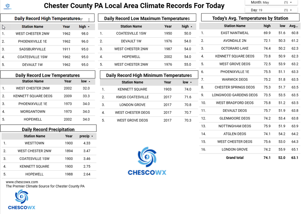
Records: Highs: EWR: 98 (1962) NYC: 99 (1962) LGA: 96 (2017) JFK: 92 (2017) Lows; EWR: 39 (2002) NYC: 38 (1976) LGA: 43 (1976) JFK: 42 (2002) Historical: 1780 - The infamous "dark day" in New England tradition. At noon it was nearly as dark as night. Chickens went to roost, and many persons were fearful of divine wrath. The phenomena was caused by forest fires to the west of New England. (David Ludlum) 1915: A spring storm came to an end after producing widespread snow. Total snowfall from the storm included: 17.6 inches in Scottsbluff, NE, 8 inches at Cheyenne, WY and 7 inches at Chadron, NE. 1955 - Lake Maloya NM received 11.28 inches of rain in 24 hours to establish a state record. (The Weather Channel) 1962: A heat wave gripped the East Coast with high temperatures reaching 99° at New York City, 98° at Baltimore, MD and 96° at Philadelphia, PA (all either broke or tied records for the month of May.). Other daily records included: Greenville-Spartanburg, SC: 99°, Newark, NJ: 98°, Concord, NH: 97°, Allentown, PA: 97°, Richmond, VA: 97°, Athens, GA: 97°, Columbus, GA: 97°, Philadelphia, PA: 96°, Atlantic City, NJ: 96°, Roanoke, VA: 96°, LaGuardia, NY: 95°, Harrisburg, PA: 95°, Wilmington, DE: 95°, Charlotte, NC: 95°, Raleigh, NC: 95°, Nashville, TN: 95°, Hartford, CT: 94°, Lynchburg, VA: 93 °F. 1975 - Thunderstorms produced golf ball size hail and wind gusts to 110 mph in Minnesota, between Fridley and Hugo. Fifty persons were injured. The hail and high winds destroyed fifty mobile homes, and a dozen aircraft, and also destroyed a third of the Brighton Elementary School. (The Weather Channel) 1977: Over a 9 day period, this was the fourth day of a terrible heat in the Chicago, IL area. Over the 9 day period, the daily high temperature was 90° or higher setting eight high temperature records. The monthly average for those 9 days was 69.3° or about 20 degrees above normal. 1987 - Thunderstorms in Texas produced thirteen inches of rain northwest of Lavernia. The heavy rain, along with golf ball size hail, destroyed eighty percent of the crops in the area, while high winds toppled trees. Golf ball size hail was also reported south of Dallas and around San Antonio. Up to eight inches of rain drenched Guadelupe County. (The National Weather Summary) (Storm Data) 1988 - Severe thunderstorms in southwest Texas produced hail as large as tennis balls around Midland, with the hail accumulating up to a foot deep. Showers and thunderstorms in the Middle Atlantic Coast Region produced 3.5 inches of rain near Schuylkill PA. (The National Weather Summary) (Storm Data) 1989 - Thunderstorms developing ahead of a cold front spawned ten tornadoes from Illinois to Tennessee during the afternoon and night. Snow, wind and cold prevailed in the Northern Plateau Region and the Northern Rockies. Dixie, ID, was blanketed with nine inches of snow, winds gusted to 87 mph at Choteau MT, and the temperature at Crater Lake, OR, dipped to 11 degrees. (Storm Data) (The National Weather Summary) 1990 - Thunderstorms deluged Hot Springs AR with thirteen inches of rain in nine hours resulting in a devastating flood. Two waves of water, four to six feet deep, swept down Central Avenue flooding stores and the famous bathhouses on Bathhouse Row. Water released from Lake Hamilton devastated the area between it and Remmel Dam. The 500 foot Carpenter Dam Bridge across Lake Catherine was completely washed away, as were cabins and mobile homes near the lake, many of which flowed right over the top of Remmel Dam. (The National Weather Summary) (Storm Data) 1997: Record maximum temperature for Washington, DC for the date is 96 °F. (Ref. Washington Weather Records - KDCA) 2002: Key West, FL recorded 4.02 inches of rain in 24 hours as a slow moving band of storms lingered over the area. Their average May precipitation is 3.31 inches. Snowflakes flew across Lower Michigan as record cold weather prevails. Record lows include the 26° at Lansing, 29° at Muskegon and 30° at Grand Rapids. The freezing temperatures cause heavy losses to orchards across western Lower Michigan. Meanwhile on the same day Fairbanks, AK reached 77°. (Ref. Wilson Wx. History) 2008Southwest:Even by American desert standards, the searing heat is one for the books. Death Valley, California sizzles at 120 °F while residents of Phoenix, Arizona witness the year's first high of 110 °F. (Ref. WxDoctor) 2009Minnesota: At 4 PM ,Granite Falls in southwestern Minnesota bakes with a temperature of 100 °F while residents of Grand Marais on the Lake Superior shore shiver with a 34 °F (a difference of 66 °F). (Ref. WxDoctor) 2018: May 19th had 0.50 inches of rain a 9-year daily record for the date; the previous record was only 0.09 in 2015. Glen Allen would get 9.20 inches of rain by the time this Weather system had finished on the 19th. This was from moisture come up the coast from Florida with a stationery just north of central Virginia. Also more than 10 inches of rain fell in SW Henrico County during a 4 day period of May 16 to May 19th. (Ref. Richmond Times Dispatch)
-
I have friends in Franklin, actually a little south of Franklin near Independence HS. .
-
Heh... probably just the operation run dance.
-
Sunday 89 Monday 95
-

2026-2027 Strong/Super El Nino
A-L-E-K replied to Stormchaserchuck1's topic in Weather Forecasting and Discussion
bummer tbh -
They rarely make it this far east anymore. There's a chance of a line forming giving the clash of air masses. Typically those lines are broken up and not well organized, at least by the time they get here. So I'm going to guess, overall, not much (<0.2") for the majority of the sub.
-
Severe WX has been MIA on the I-95 corridor thus far this spring. I would love to see an inch of rain tomorrow, but unlikely.
-
Saw my first spotted lanternfly (black with white dots) waiting for the bus. I promptly killed it.
-
(002).thumb.png.6e3d9d46bca5fe41aab7a74871dd8af8.png)
Central PA Spring 2026 Discussion/Obs Thread
ChescoWx replied to Voyager's topic in Upstate New York/Pennsylvania
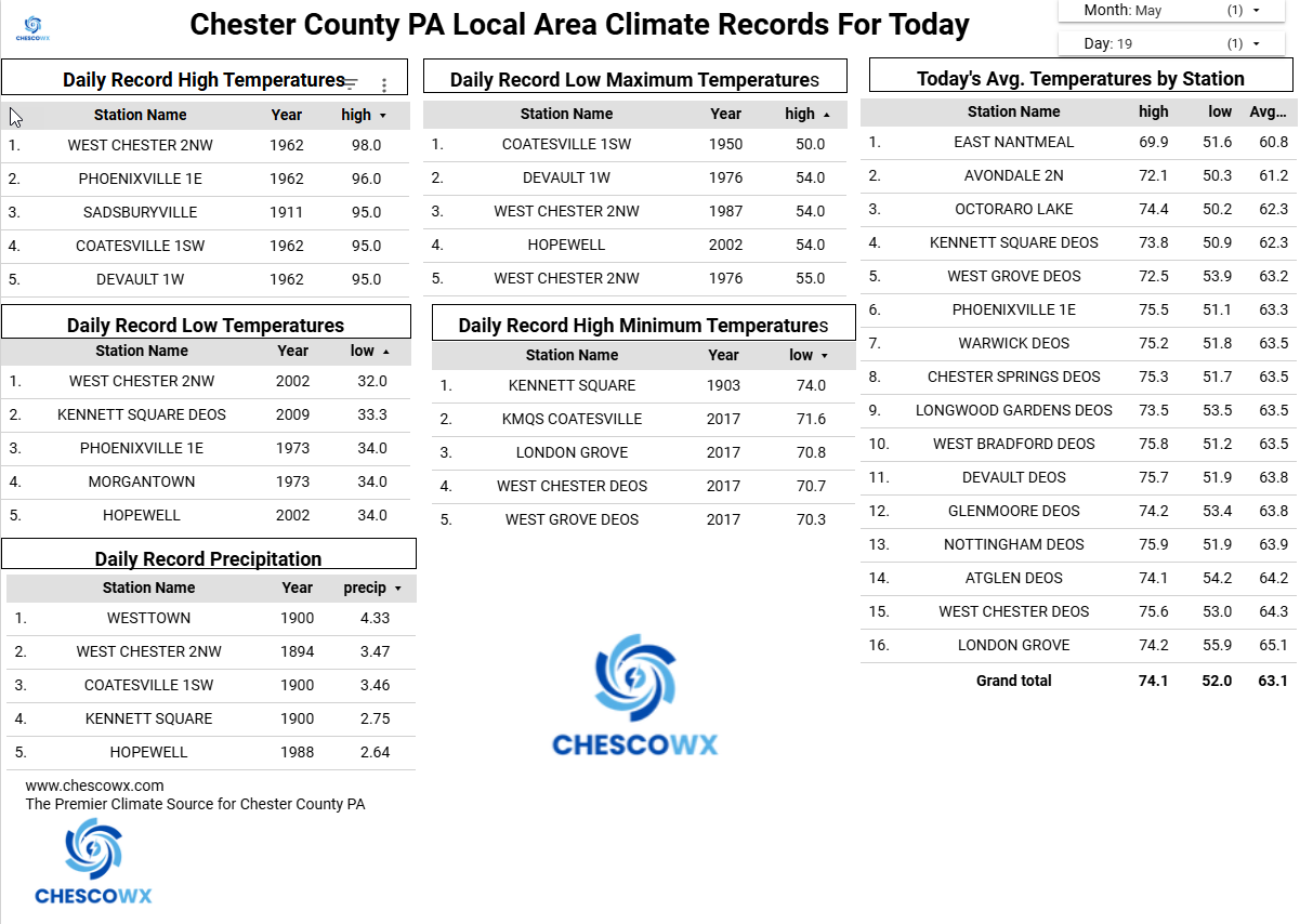
Today will be the hottest day of our brief warm up with today reaching the 90's in all areas - maybe even in the higher spots like here in East Nantmeal. This will however be nowhere close to record levels with the mid to upper 90’s record heat for this date set way back in 1962 remaining safe. Tomorrow will be several degrees cooler and may not reach 90 in all areas. Rain chances will be ramping up with an approaching cold front tomorrow later in the day and will continue through Sunday. Some models are hinting at some of the most beneficial rains we have had in quite some time. We turn chillier than normal for the Memorial Day weekend with highs likely to remain in the 50's to near 60 degrees both Friday and Saturday. The area farmers and green thumbs have their fingers crossed even if it could impact some holiday plans.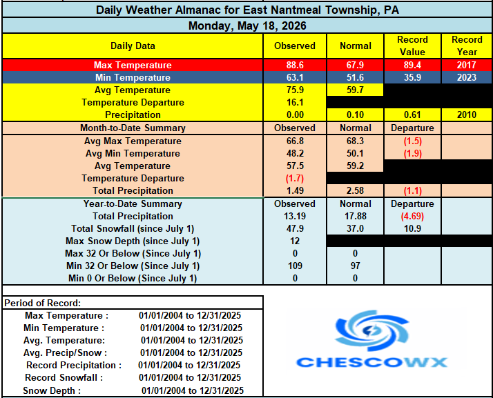
-
E PA/NJ/DE Spring 2026 Obs/Discussion
ChescoWx replied to PhiEaglesfan712's topic in Philadelphia Region
Today will be the hottest day of our brief warm up with today reaching the 90's in all areas - maybe even in the higher spots like here in East Nantmeal. This will however be nowhere close to record levels with the mid to upper 90’s record heat for this date set way back in 1962 remaining safe. Tomorrow will be several degrees cooler and may not reach 90 in all areas. Rain chances will be ramping up with an approaching cold front tomorrow later in the day and will continue through Sunday. Some models are hinting at some of the most beneficial rains we have had in quite some time. We turn chillier than normal for the Memorial Day weekend with highs likely to remain in the 50's to near 60 degrees both Friday and Saturday. The area farmers and green thumbs have their fingers crossed even if it could impact some holiday plans.
-
79 / 68 the hear is on the next 36 hours. Mid - upper 90s , stray 100s today. Tomorrow just as hot if the front is later in the PM, otherwise the caveat is a bit cooler. Showers, storms. Front sags and stalls , upper trough cuts off in an otherwise strong ridge, stuck beneath clouds, showers, rain , easterly flow Thu- Sun. Perhaps we can salvage Memorial Day. rain >1 - 2.00 is possible between the cold front wed and Sunday. Ridge remains achored in the east and quick rebound into the 80s by Tuesday. Euro backs in the cut off but will see, overall warmer once passed the abysmal period coming up. 5/26 - beyond looks above normal.
-
Charlie you are again misinterpreting the data. The increasing hot years in Philly during recent years is of course the UHI contamination at PHL.
-
Currently 79 here. I think the record high temp of 95 set back in 1996, is in jeopardy today.
-
Any guesses on how much precip we will receive tomorrow region wide?
-
Western wildfire season gonna be apocalyptic I fear
-
I think he's referring to the 00z operational GFS ? It pretty much stalls it all S and never gets QPF in here. 6z was more pessimistic. Euro trended tho... It seems the blend of the operational runs is less overall, and with that gyre over the Maritime of Canada having that polar jet around the SW side it does offer an argument to suppress. It's an interesting battle with that. If that vortex up there weakens the shits flood in. The other aspect ...it seems the whole body of the schmootz rising up in latitude is warm frontal more than cyclonic. It'll have that typical book-end fake low on the west end of it as usual but it's mostly just the cool air from Wed fropa having over exceeding the hemispheric signal, so ...said signal reasserts by rising back over the top enough to crank the weekend. Anyway, Euro at least hints at saving Saturday. Prior runs had that day miserable by 10am down there in CT and checked out by 2 up here. If it holds off just another 10 miles you're golden.
-
lmao guidance for BDL tomorrow MAV: 84 MET: 84 NBM: 95 (though showing a 3hr max of 88)
-
Yeah I've noticed it's been speeding up ... Looks like it's thru western NE by noon.
-
I'm not sure the FIT one is right. There is/was a warm boundary sort of washing out overnight, but at 1:35 am that site was 61 F like everywhere around it within 10 clicks, then ...2:15 am it's 77. Seems a bit handsome for that hour of the night. I checked some of the surrounding NWS tweener sites and they did show a modest indication for some sort of warmth penetrating the sfc but not 15 to 17 worth - not even close to that amount. Not sure. Seems suss
-
0.22" early this morning to bring the 4-day system total to 0.81". Seems like we have a yo-yo going on here with the moisture. Slammed in April with 7+ inches, this month will likely end up around 1 inch. Hopefully in June we can get another 7-8" to make up for May.
-

2026-2027 Strong/Super El Nino
snowman19 replied to Stormchaserchuck1's topic in Weather Forecasting and Discussion
IMO the Niña-like MJO (IO) forcing comes to an end with this El Niño once the +IOD gets established. The standing wave Nino/+IOD forcing combo is going to cause the eastern IO SSTs to upwell and cool off, causing subsidence in that region