All Activity
- Past hour
-
Pre or around Thanksgiving snow has historically been the kiss of death for the rest of the winter.
-
The weather is so boring! This is the Snotober and Sandy anniversaries!
-
Fake ?
-

2026-2027 Record-breaking El Nino
GaWx replied to Stormchaserchuck1's topic in Weather Forecasting and Discussion
John, As long as the 10 hPa/60N mean zonal winds reverse (go to <0) in Nov or winter, that event is defined as a major SSW regardless of the degree of actual strat. warming and degree of propagation down into the troposphere, if at all. If it doesn’t drop to <0, the strat warming event is called a minor SSW. Despite the reversal or at least near reversal being progged on models, the degree of actual warming at 10 hPa being progged has been rather tame compared to many other SSWs. So, that could very well be a factor to consider as regards its potential to later significantly disrupt well down into the troposphere. I wonder if that reduces that potential. Opinions? -
We had a big dog last winter, 12-16" locally. It would be unprecedented for us to have another one this year since they tend to occur every 13 or 14 years lol. But this does seem like one of those winters that could be mainly mild throughout but also hold a couple of surprises for the forum. Crazy cutoff lows generating enough cold for snow, perfectly timed, juiced up phasing, etc. Even 97-98 had a crazy storm that pummeled the southern OV in the middle of an otherwise, boring, mild, el nino winter. I still love a good snowstorm but with my growing intolerance for cold, this could be the perfect winter.
-
Kev, maybe you should set up a little vegetable stand in your front yard….”Kevin’s extended season farmers market.”
-
Only a matter of time...
-
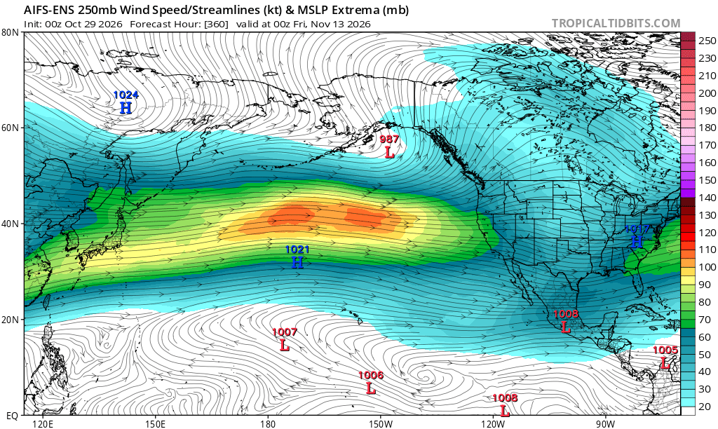
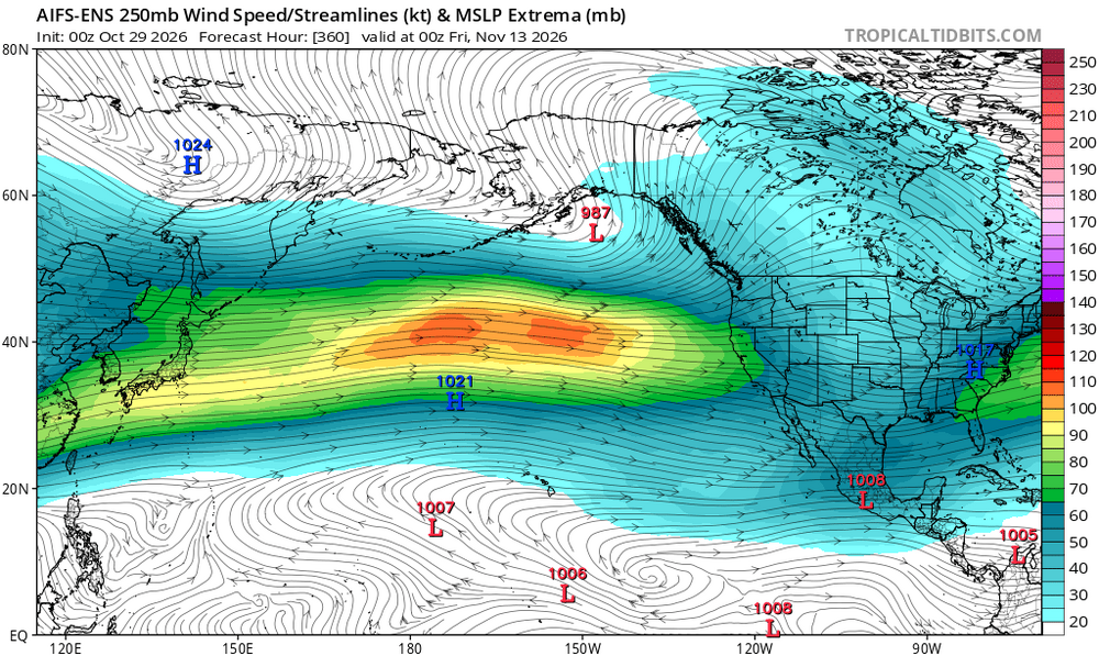
Cape's going to luuuuuuuuv your posting that map. Lol
-
For sure.
-
It’s been great. Enjoy it…the misery mist and cold rain of November is coming for us all.
-

2026-2027 Record-breaking El Nino
forkyfork replied to Stormchaserchuck1's topic in Weather Forecasting and Discussion
-

2026-2027 Record-breaking El Nino
Typhoon Tip replied to Stormchaserchuck1's topic in Weather Forecasting and Discussion
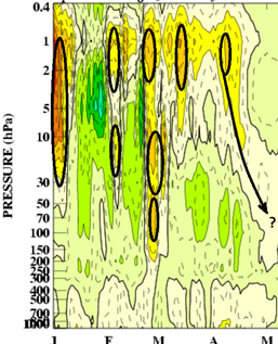
I'm not seeing the complete suite off the Euro cluster ... but, the GEFs I've always used do not indicate an SSW... There's some wild confusion going on, as some folks among this social media, and outside of it, are seemingly not even aware of their confusion: appears just just wrongly attributable in what is going on.... First of all, warm thermal events pop off in the PV/stratospheric altitudes, all the time. Seldom are they down propagators after the fact, a key behavioral component in the Sudden Stratospheric Warming defined phenomenon. The modeling presentation I've found at https://www.cpc.ncep.noaa.gov/products/stratosphere/strat_a_f/ (NCEP/GFS Analyses and Forecasts) provides a means ( though could be improved ) to deduce if in situ outlooks for warming at those respective levels ( y-axis of the above annotated graph) may be destined to downwell. Note the unit conversion from MB to hPa (millibars to hectopascals) a conversion they do to be consistent with SI units. When you see an warm sudden introduction in the 1 thru 10 hPa, then look at the 30 --> 50 --> 70 ...etc, out in time. If the pretty red blob of the polar stereographic thermal anomaly layout are then subsequently introducing the warmth, that is at least a 'reasonable' implication of an actual downward welling behavior. If you don't see that... it's probably an event that is like this... Ie., no propagation. Having defined/illustrated these different types of stratospheric warm event basics ... just as a knowledge aspect, there does not appear to be a temperature extreme/amplitude dependency in whether an event is a propagator or not. As this image above demos, I carefully choose; it shows multiple irrelevant perturbed warm introductions. However, the last in the series there, very late in the spring of 2007, vaguely suggests there was a downward mass propagation. The key take away is the down ward movement of the temperature (warming) anomaly. We are thus using the temperature fields to infer wave mechanics taking place that will eventually become important in situ to the stratosphere-troposphere coupled model. There may be amplitude requirement the physical wave mechanics - intuitively that's no brainer. A weak downward temperature signal ... prooooobably is indicative of a weak collapsing PV ..which then weakly correlates to AO modality. Otherwise, no propagation, no crucially defined SSW event. Now, if we want to call any warm protuberance that introduces itself at all ... like those spanning that winter of 2007, as a SSW? we do so at risk of confusing and conflating the two disparate systemically effective events - like what sounds like is happening now... I did go over the modeled GFS hPa levels wrt time ... it appears around 240 hours, there is a moderate 10 hPa warm emergence, but subsequent time intervals at successively lower levels do not present any propagating behavior. That can change - sure. We're not excluding the possibility that an actual SSW will happen this year in the unusually early November window. Just not seeing it right now. Having said all that... look at the 70 and 100 hPas... There's something else happening, already, ...partly I suspect is contributing to some folks misconception of what's going on. There is a coherent warm anomaly that is all but statically occurring in those lower stratospheric levels... That is is not SSW, but... I believe it is related to CC invading the fixed hPa aspect of the monitoring system... speculation -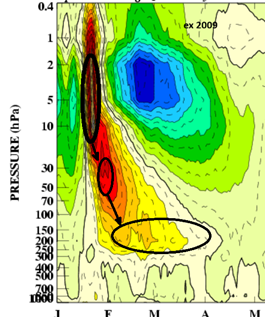
-
A general 0.30" of rain from the shwrs/stms that moved through yesterday evening in the TH area. Nice to get some precip.
-
775 NWUS53 KDLH 282303 LSRDLH Preliminary Local Storm Report National Weather Service Duluth MN 603 PM CDT Wed Oct 28 2026 ..TIME... ...EVENT... ...CITY LOCATION... ...LAT.LON... ..DATE... ....MAG.... ..COUNTY LOCATION..ST.. ...SOURCE.... ..REMARKS.. 0540 PM Tornado 3 SE Danbury 45.98N 92.33W 10/28/2026 Burnett WI Public Weak, brief rotation on the ground, kicking up small branches, leaves, and water as the rotation passed over Love Lake. No damage as of now. && $$ KML
-
if data need to be corrected and aren't, the data are incorrect
-
Next week's system may need to be watched for a severe threat. Very dynamic system developing over the plains it seems. We will be firmly in the warm sector
-
That whole scene is all about clicks and views and why forums will always be goated for real heads. When joe or someone else drops knowledge here its for pure love of the game
-
These beautiful days, man
-
Places in TN have been colder than you. Tri Cities airport hit 33° this month.
-
 canada pharmacy world: CanPointeRx - certified canadian pharmacy
-
yeah but overall it's been warm and dry outside of a few days
-
Yesterday wasn’t torchy here. And Tuesday wasn’t either. Today will be warmer though.
-
If anything is fake…it’s that. Most everybody else has froze. But, as I pointed out yesterday, there is nothing fake about any sensible weather. Including your hill top not frosting yet. It’s real. Just as everyone else’s freezes are real.
- Today
-
Another week or so of dry weather and torchy afternoons
-
It’s been awesome . Just fire and warm. All realness . Nothing fake