All Activity
- Past hour
-
Yes for NYC
-
Pinatubo influenced Don
-
Still mostly cloudy here but getting better
-
haha glad it's not here, almost completely sunny after some clouds earlier today.
-
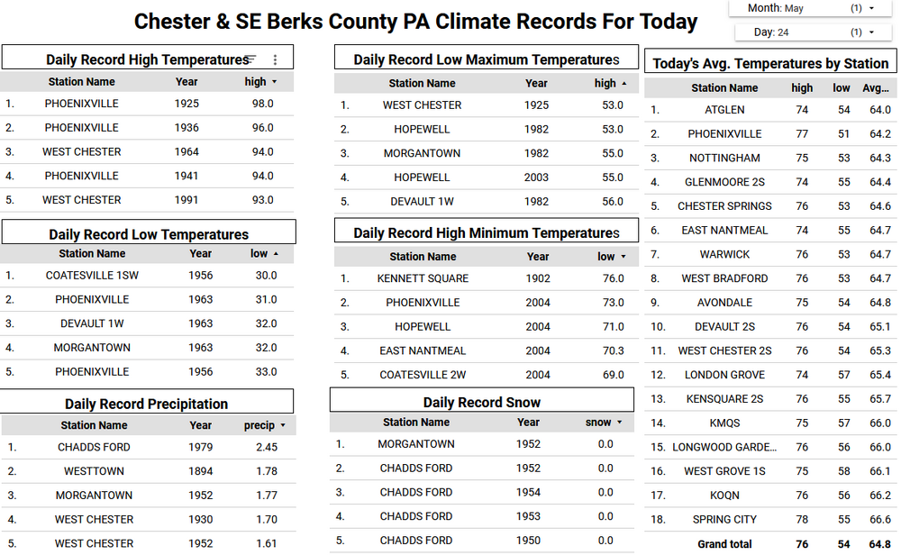
Lows:EWR: 40 (1963)NYC: 39 (1963)LGA: 41 (1963)JFK: 41 (1963) The latest 30s ever recorded at Central Park, Tony?
-
not bad, our lowest high was 55 here
-
Good, this is exactly what I'd hoped.
-
it's the best, humans modify everything, nothing is untouchable not even the weather. There was a 30 minute shower yesterday right around sunset, pretty heavy rain, while it rained I had an allergic attack, Before it rained and after it rained everything was fine.
-
seems like I've been saying that myself for 10 days worth of runs ... should'a done been here by now
-
Might be a little early with this monthly... but I like the pattern for summer warmth (daily 80s at least inland the first week of June). 5H Weakness in our area suggests cool frontal passages and a chance for frontal showers/tstorms so drought hopefully doesn't return in June. GEFS from 00z/23 through June 25 suggests ridge centered NMex/TEX with zonal flow N USA and maybe periodic chance at 90F with a strong TStorm near CFP? Long ranging is difficult for ensembles. Others may want to add EC suite etc outlooks for June. Monthly trend is warmer than the 30 year average so I dont see a reason deviate. Don? Other's?
-
Bachelor party in Newport today. Have to make chicken salad out of chicken shit
-
Oh look. Roaring wind again. Shocker. I'm ready for 95/70 if that means no f***ing wind lol
-
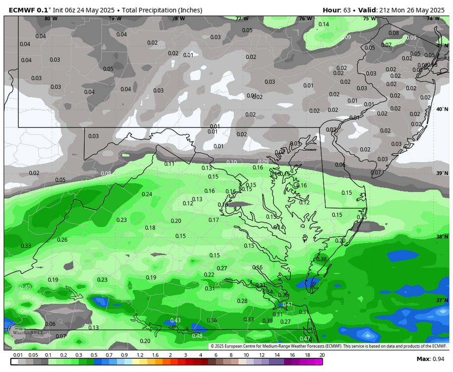
WB 6Z EURO is bringing in some showers DC south for Memorial Day.
-
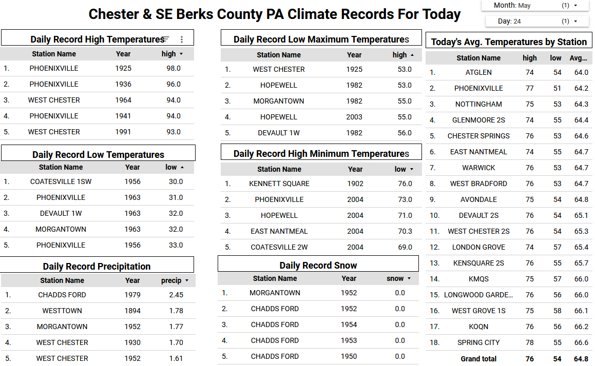
Yesterdays highs - the wet park 4 degrees below the major stations TEB: 69 PHL: 69 BLM: 68 ACY: 68 EWR: 67 LGA: 67 New Brnswck: 67 JFK: 67 TTN: 67 ISP: 63 NYC: 63
-
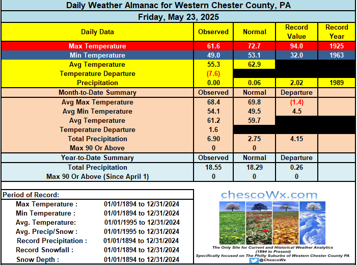
A beautiful Memorial Day weekend underway across the area although at least 10 degrees below our normal highs for the day. Still relatively chilly tomorrow but temperatures do rise to within 5 degrees of normal by Monday with highs near 70 degrees. Rain chances increase again by Tuesday night and Wednesday and we will again turn well below normal temperature wise. Shower chances continue for much of the rest of the week with temperatures still a few degrees below normal for the end of May.
-

2025 Spring/Summer Mountain Thread
Met1985 replied to Maggie Valley Steve's topic in Southeastern States
I just missed getting to in the 30s with a cold crisp low of 40 degrees. -

E PA/NJ/DE Spring 2025 Obs/Discussion
ChescoWx replied to PhiEaglesfan712's topic in Philadelphia Region
A beautiful Memorial Day weekend underway across the area although at least 10 degrees below our normal highs for the day. Still relatively chilly tomorrow but temperatures do rise to within 5 degrees of normal by Monday with highs near 70 degrees. Rain chances increase again by Tuesday night and Wednesday and we will again turn well below normal temperature wise. Shower chances continue for much of the rest of the week with temperatures still a few degrees below normal for the end of May.
-
The next 7 days dries out stays near normal overall once to Monday with the main areas of heavy rain south of here.
-
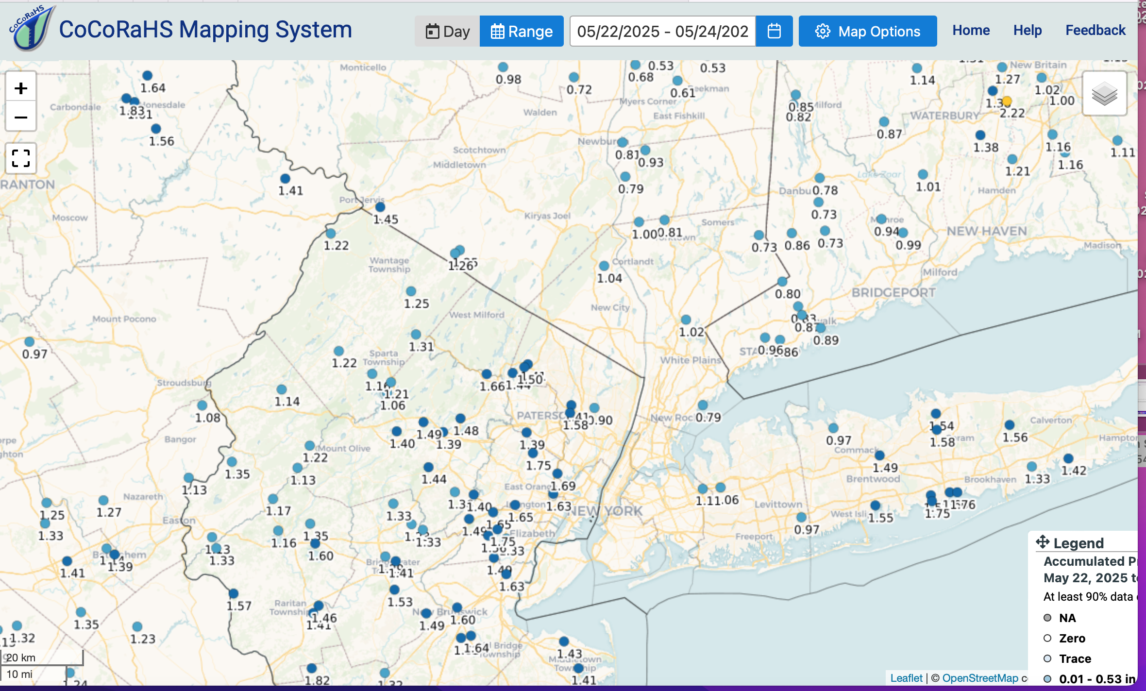
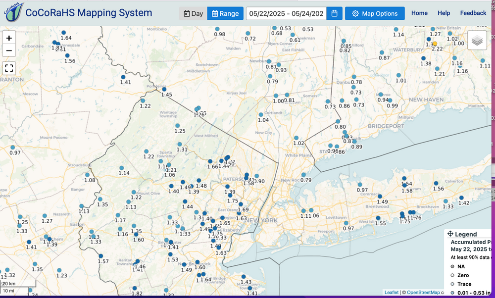
3 day totals via CoCoRaHs reports which looks good including NYS Mesonet and my Wanted 1.25. Drought over for the time being, as per last Tuesday's report and this attached data that goes into the 5/27 report publicly available 5/29. EC suite was overdone for this period, no doubt...both wind and rain. Looks to me like milder this coming weeks 70s morphs into summer June 1, more or less on schedule with at least 80s almost daily the first week of June, excepting coastal sea breezes. CoCoRaHs 3 days attached-click for clarity.
-

2025 Mid-Atlantic Garden, Lawn, and Other Green Stuff Thread
dailylurker replied to mattie g's topic in Mid Atlantic
I've had good success with seed from American Meadows. They have native flower mixes for our area. Nothing eats the flowers and they are drought resistant. -
40’s? Should be 50’s for lows even some dews later in week or weekend
-
Summer returns after next weekend. It’s coming.
-
My Mom would tell me, “ remember you are judged by the friends you keep”. Well done, forky, as always…..
-
EWR: 5/19: 73 / 52 (-1) 5/20: 71/50 (-3) 5/21: 59 / 50 (-10) 5/22: 53 / 50 (-13) 5/23: 67 / 48 (-7) NYC: 5/19: 69 /51 (-4) 5/20: 67 / 49 (-6) 5/21: 59 / 49 (-11) 5/22: 51 / 48 (-15) 5/23: 63 / 47 (-10) LGA: 5/19: 70 / 52 (-4) 5/20: 68 / 50 (-6) 5/21: 59 / 49 (-11) 5/22: 53 / 48 (-15) 5/23: 67 / 48 (-8) JFK: 5/19: 74 / 53 (+3) 5/20: 69 / 50 (-3) 5/21: 58 / 50 (-8) 5/22: 55 / 49 (-10) 5/23: 67 / 48 (-5)
-
Records: Highs: EWR: 93 (1964) NYC: 93 (1975) LGA: 91 (1964) JFK: 86 (1964) Lows: EWR: 40 (1963) NYC: 39 (1963) LGA: 41 (1963) JFK: 41 (1963) Historical: 1877: Heavy snows occurred over parts of the northeast and New England. 4 inches of snow fell in Berkshire County, Massachusetts. 1894 - Six inches of snow blanketed Kentucky. Just four days earlier as much as ten inches of snow had fallen across Kentucky, Tennessee and Virginia. Six days earlier a violent storm had wrecked nine ships on Lake Michigan. (David Ludlum) 1930 - A tornado touched down near the town of Pratt, KS, and traveled at the incredibly slow speed of just 5 mph. (The Weather Channel) 1940 - Hail fell near Ada OK to a depth of six to eight inches, and rainfall runoff left drifts of hail up to five feet high. (The Weather Channel) 1987 - Severe thunderstorms in southwest Texas spawned a couple of tornadoes near Silverton, and produced golf ball size hail east of the town of Happy. Thunderstorms also produced large hail and damaging winds in Louisiana and Texas. (Storm Data) (The National Weather Summary) 1988 - Thunderstorms produced severe weather in the southeastern U.S. Thunderstorm winds gusted to 88 mph at Columbia, NC. Baseball size hail was reported near Tifton GA. (The National Weather Summary) (Storm Data) 1989 - Thunderstorms developing ahead of a cold front produced severe weather across the Upper Midwest through the day and night. Thunderstorms spawned 30 tornadoes, and there were 158 reports of large hail and damaging winds. A strong (F-3) tornado caused five million dollars damage at Corning, IA, and a powerful (F-4) tornado caused five million dollars damage at Traer, IA. Thunderstorm winds gusting to 88 mph killed one person and injured five others at Stephensville, WI. (The National Weather Summary) (Storm Data) 1990 - Severe thunderstorms spawned two dozen tornadoes from Montana to Oklahoma. Four tornadoes carved a 109-mile path across central Kansas. The third of the four tornadoes blew 88 cars of an 125-car train off the track, stacking them three to four cars high in some cases, and the fourth tornado caused 3.9 million dollars damage. The third tornado injured six persons who were trying to escape in vehicles. A woman was "sucked out" of a truck and said that at one time she was "airborne, trying to run but my feet wouldn't touch the ground". She also saw a live deer "flying through theair". (The National Weather Summary) (Storm Data)