All Activity
- Past hour
-
Wound up with almost a half iinch here today. A Station just east of Sneedville recorded 3.17 inches !
-
Euro is also a step to the gfs
-

-
Scored two thunderstorms within a couple hours of each other tonight. Best rains were west and south of me but I still managed about 3/4 of an inch.
-
Happy Birthday
-
-

2025-2026 ENSO
Stormchaserchuck1 replied to 40/70 Benchmark's topic in Weather Forecasting and Discussion
That's vs the global temperature. I made this graph last year, it's a smoothed out AMO index since it went positive in 1995. It appears that we still seem to be in a rising phase. Also, the NAO has been very positive May-Aug, just like last year. Such +NAO in the warm season has a -0.3 SSTA correlation in the south-central Atlantic. A lot of the cool water this year is because of such a strong +NAO... It's been positive 8 of the last 9 months. -
TWN had storms honed for my region, they formed elsewhere just to my east like 2-3 years ago that one summer they spawned just miles east every time. Kitchener got some and this MCS appeared to bow out a bit after the city. It was heavy rain cells with thunder I presume but one gained just east of downtown Toronto. Liked the air out there today, 27C. Fantastic summer all around.
-
I'm not. I have a very big party for my father and mother-in-law for their 80th birthday next Saturday. I have about 40 to 50 people coming.
-
37.2 this AM.
-
True. There is a clear warm migration in the reliable station data regardless of the images. The resolution change between the maps just left a bit to be desired in the comparison. I assumed the first map was biased cool because of smoothing in some areas, like the NH sea coast.
-
Now, maybe these trends reverse and guidance will be wrong, but that is not what we are seeing now. It's not becoming less east-based.
-
Also, if you look at guidance, this has been expected and well forecast.
- Today
-
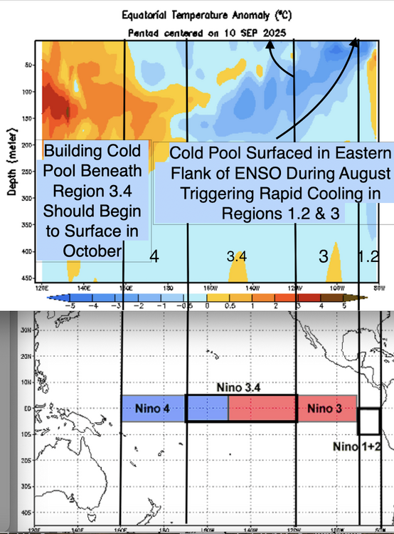
Yes, I think Jerry is focusing on region 3...while 1.2 is volatile....this marked cooling in that zone isn't a function of volatility. If you have been paying attention, the subsurface cold pool emerged due to sustained trades.
-
No; it invalidates it. The eastern zone of 1.2 began warm and the subsurface cold pool emerged there.
-
There’s definitely a big jump between the 2. Losing the 70s and 80s really extends the growing season. But there’s some lousy COOP sites in there that result in polka dots.
-
The bottom one just looks like a higher-resolution version of the top map.
-
Wow, what an impressive heat lightning show to my southeast! This comes after some afternoon storms earlier today. I will try to get some lightning shots.
-
What, are you telling me that the eastern shore doesn't get its first frost at the same time as far northern Maine?
-
Finally seeing some colder air making its way into the US and eventually SE by the first and second weeks of October. https://www.pivotalweather.com/model.php?p=sfct_anom-imp
-
heh i’d be a little bit leery of using that comparison because there’s clearly a resolution change there I.e., the bottom panel has perhaps multiple factors of greater sampling density… suggestive by the granularity
-
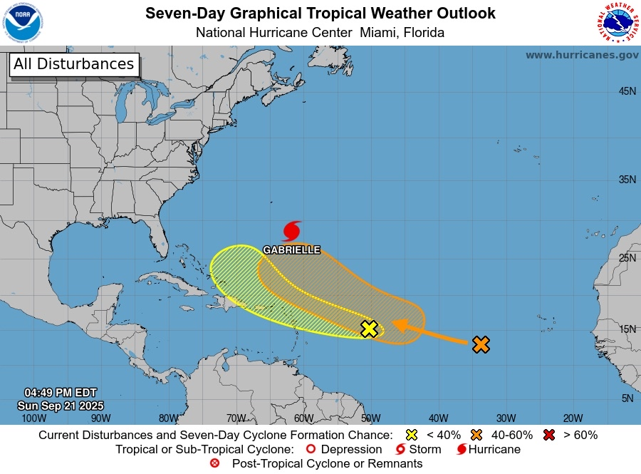
Today’s Euro Weeklies release fwiw is more active, especially in the S Gulf to NW Caribbean and including S and C FL, and is suggesting that a well above normal 50+ Oct-Nov ACE is a realistic possibility. I’ll continue to follow the EW trends.
-

September 2025 OBS-Discussion centered NYC subforum
Stormlover74 replied to wdrag's topic in New York City Metro
59 already -
Welcome! So where you are in the forum will make a difference in what people will suggest. There is so much TO do. The Ap trail isn't that far off, plenty of other trails, from steep mountains to the canal (which includes biking). Course tons of museums and the Atlantic and bay are close by. It really depends on what you like to do. I am WAY off in the western zone of forum, but plenty out this way too. Trains (both museums and rides), trails, lakes, caves and more. Again welcome!
- Yesterday
-
I overseeded on Friday. Then it rained on Sat (0.26) and last evening (0.74), so win! Course I am a touch cooler than the coastal plain area. Went 'tree peeping' today thru my county into Greenbrier county in WV, about 50% color above 2500 foot, 25-33% down lower. Maples, poplars, dogwoods, cherry and locusts changing, oaks mostly still green.


