All Activity
- Past hour
-
We are flirting with 1965 when a severe drought continued thru 1966. The + 1.8 DJF 65-66 El Nino did NOT break the 4 year drought. I simply report historical reality.
-
aren't the new models replacing some of the older models in November ?
-

2026-2027 Record-breaking El Nino
qg_omega replied to Stormchaserchuck1's topic in Weather Forecasting and Discussion
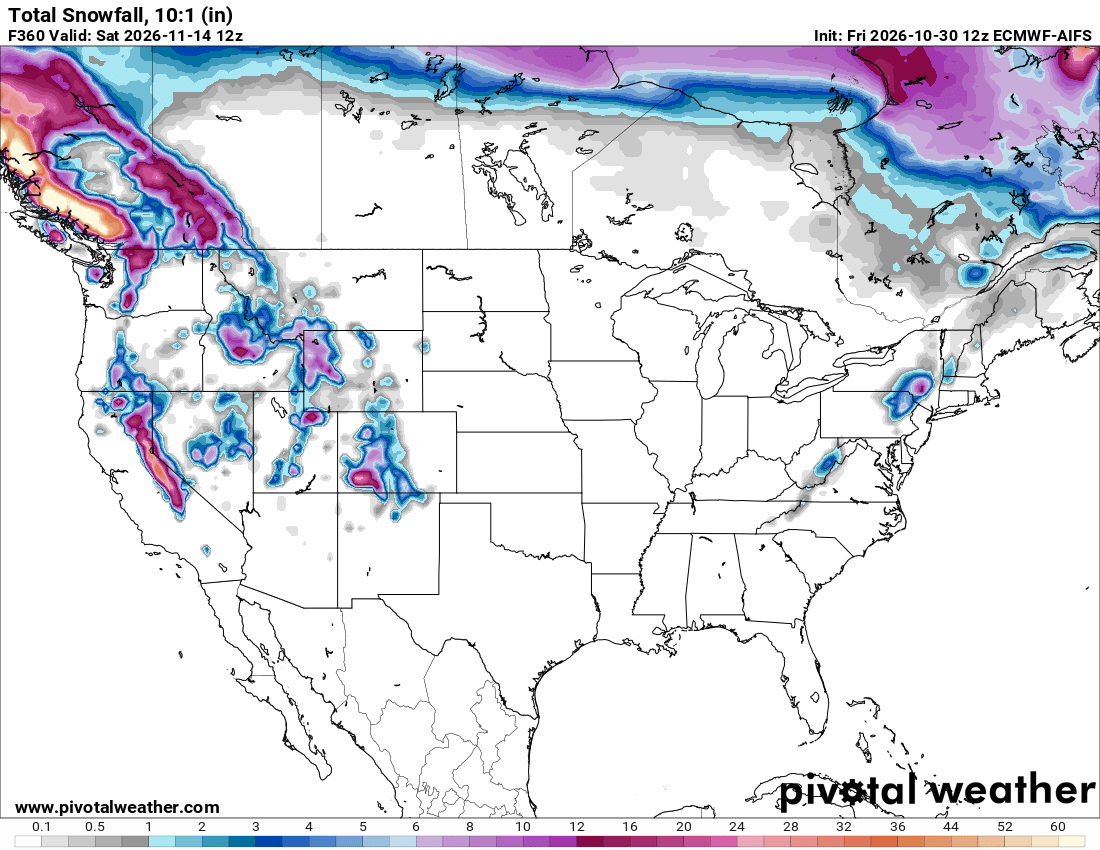
Literally shows nothing across almost all of southern Canada -

2026-2027 Record-breaking El Nino
LakePaste25 replied to Stormchaserchuck1's topic in Weather Forecasting and Discussion
The trade off here is that we probably avoid a December 2015-like outcome and instead see something closer to December 1997. -

2026-2027 Record-breaking El Nino
snowman19 replied to Stormchaserchuck1's topic in Weather Forecasting and Discussion
Massive WWB coming for early-mid next month. This will cause even more warming in regions 1+2, 3 and 3.4, setting the stage for the December peak. This super El Niño has secured and guaranteed its rightful place as the strongest and most east-based in history…. -

2026-2027 Record-breaking El Nino
bluewave replied to Stormchaserchuck1's topic in Weather Forecasting and Discussion
You are a funny guy. The reason that I point out how much warmer things have become is due to the fact that I grew up in a much colder 1970s and 1980s. This is literally a new climate paradigm. Not because I like such a warmer planet. But most people off this forum like a warmer climate since a large portion of the population has been moving to the Sunbelt from the colder regions. But there has been some small shift to this long term trend in the last few years. Since we live here near the surface and not up in the stratosphere. Numerous posts on how the stratosphere might change the eventual outcome vs the super El Niño. Not meant to single you out since I understand that you were only posting the data. But the super El Niño is a much greater climate driver in comparison. We pretty much knew where this was headed with the record WWBs last spring and the early model shift to a stronger and stronger east based El Niño. So no hopes are going to get dashed since expectations were lowered in accordance to how extreme an event this has become. The national and global climate system is much bigger than our local backyards. Last winter was our first both cold and snowy winter in 11 years. The limited area of the cold against the background of the 2nd warmest CONUS winter on record explains what has happened. The cold since the 2015-2016 super El Niño baseline shift has become extremely limited. So the chances of any one winter being both colder and snowier than average is becoming less likely. The geographic footprint of the cold when it does occur is more limited. So this new pattern made it possible for us to go this long before experiencing a colder winter. In the old days it was possible to get coast to coast widespread cold. So our chances for a colder winter in any given location were greater. These days we can’t get a colder winter winter in a portion of the CONUS without a much more impressive warm winter so where else. We were discussing snowfall before last winter and during previous winters. I was very happy to get the benchmark storm track back for the first time since 21-22. But it highlights how important the benchmark track is for our snow especially since the mid-90s. In the colder climate prior to the mid-90s, we could nickel and dime our way to normal snowfall especially around NYC Metro. It was possible during the colder era to have an average snowfall season with just small or moderate events. But for the last 30 years getting a KU benchmark storm has become a prerequisite. This has lead to the snowfall for places around NYC to become an all or nothing proposition with hardly any more seasons near the mid-20s average. I also said in earlier years that it would be a struggle to get another 50” snowfall season in NYC with how warm the winters have become. Since NYC proper needs a winter close to 32° in order to pull this off. The colder temperatures are necessary but not always sufficient like we found out last winter. Areas like Islip to the east and Newark to the west don’t fall into this category which I also pointed out years ago. So it’s more of a NYC and surrounding stations like LGA and JFK requirement. -
71 today at my stations. Trees are really popping with color now as well.
-
Windy
-
torchvember incoming
-

2026-2027 Record-breaking El Nino
SnoSki14 replied to Stormchaserchuck1's topic in Weather Forecasting and Discussion
Not gonna lie if winter is gonna be like its been the last 2 weeks then sign me up. Yes it's dull as dirt, San Diego style weather, but it feels great. I know we'll pay for it next spring/summer though. Summer 2027 will be a complete global disaster. -

2026-2027 Record-breaking El Nino
mitchnick replied to Stormchaserchuck1's topic in Weather Forecasting and Discussion
In these parts, November snow is rarer than March snow so temps are pretty meaningless. I'd rather save the oil for when it counts anyway. Lol -
 mexican rx pharm: FronteraCare Direct - mexico rx
-
Gfs is complete garbage now. I only look at Euro/Euro AI
-
mexican rx pharm: FronteraCare Direct - mexico rx
-
72
-

2026-2027 Record-breaking El Nino
michsnowfreak replied to Stormchaserchuck1's topic in Weather Forecasting and Discussion
The first half of November will definitely be warmer than avg. November (at least here) is the most rapidly changing month of the entire year from first day to last. So with the natural transition from Fall to winter alone, I would expect the second half to be solidly colder than the first, but in the end, highly confident anyone in the north finishes the month on the cool side of normal is an ill-advised call. -
2026-2027 Record-breaking El Nino
snowman19 replied to Stormchaserchuck1's topic in Weather Forecasting and Discussion
Ok -
https://canpointerx.shop/# canadian pharmacy ratings
-

2026-2027 Record-breaking El Nino
MJO812 replied to Stormchaserchuck1's topic in Weather Forecasting and Discussion
Bamwx likes a cool November -
2026-2027 Record-breaking El Nino
MJO812 replied to Stormchaserchuck1's topic in Weather Forecasting and Discussion
You predict that every year. -
2026-2027 Record-breaking El Nino
mitchnick replied to Stormchaserchuck1's topic in Weather Forecasting and Discussion
Yet, the Euro-AIFS shows decent snow in southern Canada the 1st 15 days of November. I'd show further north, but Pivotal doesn't offer that map. Even some in the NE US.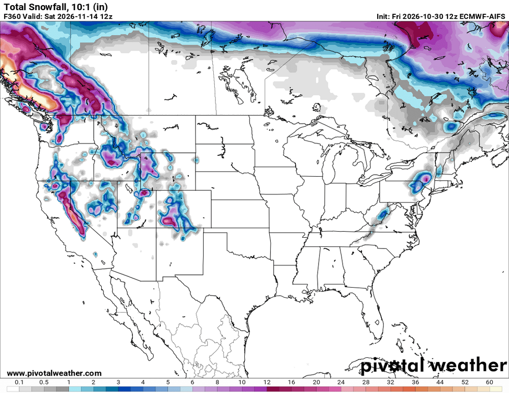
-
2026-2027 Record-breaking El Nino
michsnowfreak replied to Stormchaserchuck1's topic in Weather Forecasting and Discussion
What weather enthusiast wouldnt marvel about how warm it is in Phoenix when theres a blizzard in his own backyard? -
-
I have a few pretty tall beeches out back, some are still hanging on (the small ones are toast). had a good -sized one next to the house that finally gave in this year.
-
hate to say it but ok with a warm early Nov. Lets get some flurries the week of Thanksgiving and sounds like a great November. We need rain. That is the biggest issue.