All Activity
- Past hour
-
Hopefully burns off a bit. I love that area. Maybe check out the seals in Chatham harbor and grab a lobster roll there lol.
-
Hopefully this clears out a bit in the next hour or so.
-
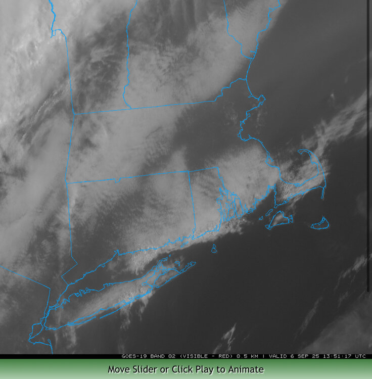
12z NAM has a pocket of 1500-2000+ J of MLCape across western Mass into northwest CT. That would be noteworthy given the shear.
-
We warned em’
-
I’m not at the beach lol. Got to do some yard stuff today. Beach gets hard to do this time year with Fall sports now too. I can only pretend to be where Radarman is.
-

September 2025 OBS-Discussion centered NYC subforum
RU848789 replied to wdrag's topic in New York City Metro
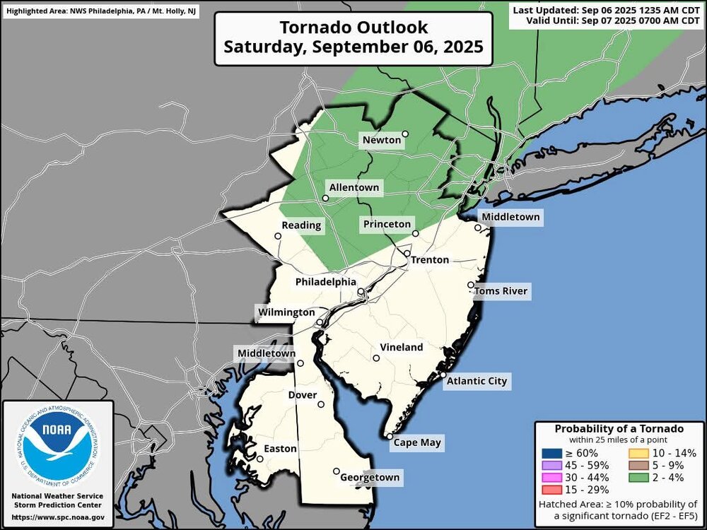
Most of the 0Z and 6Z models have 0.2-0.5" of rain from 2-8 pm today for most of the Philly-NJ-NYC region (when we're both interested for the RU game and my son's wedding), but many have lollipops of 1" or more, so as usual it all depends on where the heavy downpours hit - won't be everywhere, but they'll likely be fairly widespread. Most of the models also have 1/2" or more after 8 pm. -

September 2025 OBS-Discussion centered NYC subforum
winterwarlock replied to wdrag's topic in New York City Metro
im going to the Rutgers game so worried about heavy rain and lightning delay but really the modelling doesnt seem to be matching some of the hype and the models seems all over the place on timing..such as the hrrr which is later and some others earlier. This looks way less than the Thursday event which of course the models got wrong too -
61/55 with hoodies. Be glad you are at the beach today and not up north.
-

September 2025 OBS-Discussion centered NYC subforum
Stormlover74 replied to wdrag's topic in New York City Metro
For you this is true -
Don't know if it was the cool August, or the lack of rainfall, but in just one week, we've had an "explosion" of tree color here in Tamaqua. Maybe only 5-10 percent, so not a lot, but last week it was basically zero percent.
-
September 2025 OBS-Discussion centered NYC subforum
winterwarlock replied to wdrag's topic in New York City Metro
the models really dont have a lot of rainfall on them -
With the right conditions, even in late month. On 9/30/86, straight-line winds flattened about 600 acres 13-14 miles SE from downtown Fort Kent, a swath 4 miles long and up to 1/2 mile wide, ending with trees blown into Square Lake. Damage was near 100%, probably 90-100 mph gusts. I don't know if CAR ever investigated - would've had to been within 6 weeks of the event as the area had a 20"+ storm on 11/20-21. (Irony: 5 years later, same date [9/30], the area had 3-4" snow.)
-
Peak beach season. No crowds. Warm water (usually). Free. Unfortunately it's pretty dark to the west. CHH looks like the best bet today.
-
There is very good support this time for a big shakeup in the pattern by October. Projected tropical forcing/MJO, -ENSO, -PDO, -IOD. I am becoming increasingly confident that October is very likely to be warmer to much warmer than normal….also potentially much drier than normal as well
-
September 2025 OBS-Discussion centered NYC subforum
Stormlover74 replied to wdrag's topic in New York City Metro
You should be good. -
September 2025 OBS-Discussion centered NYC subforum
Stormlover74 replied to wdrag's topic in New York City Metro
-
Seems like wrn ma into SNH favored today. However may see some training in areas of CT later into NE MA?
-
Heading down to The Anthem tonight for a concert. Looks like we may catch some of the rain forecasted down there.
-
78/72. Aaahhhhhh.
-
One thing to keep in mind. Not that anyone should discount the Eps, but the AI EPS has done much better with the cooler air in the last month+ as I mentioned a few pages back and that BAMWX also noted. Anyone with a Wxbell or Weathermodels subscription, do they offer long range AI EPS? Tia
-
Bong?
-
Because the usual seasonal forecasts that relied on past tools have become much more varied in our new CC era. There's too many variables that are interfering with one another and are producing outcomes we've never seen before.
-
Hrrr likes the stratiform precip
-
Going on day 12 <80F. That's probably about normal but would seem pretty hard to do this time of year. 74/70 with filtered sun.
-
Smoke makes me angry


