All Activity
- Past hour
-
And so it begins RECORD EVENT REPORT NATIONAL WEATHER SERVICE PEACHTREE CITY GA 0834 PM EDT SUN MAY 17 2026 ...RECORD HIGH TEMPERATURE SET AT ATLANTA... A RECORD HIGH TEMPERATURE OF 90 DEGREES WAS SET AT ATLANTA TODAY. THIS TIES THE OLD RECORD OF 90 DEGREES SET IN 1960.
-
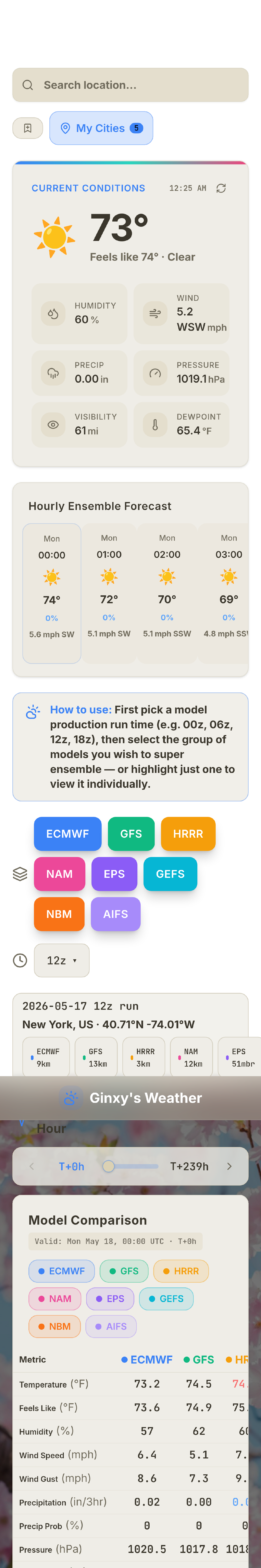
Still updating and taking suggestions. One page shopping create your own super ensemble https://ginxweather.com/
-
Lol
- Today
-
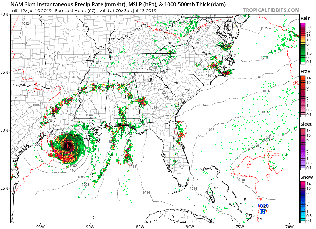
On the topic of the NAM going away and all the "consternation," remember what it can do w/ TCs. Look at this from Barry in 2019 (attached). 866 mb? Yeah, right. And you'd get hype-masters out there posting such as if it could happen! Barry ended up a min hurricane, but even that was really pushing it! Saw this... NAM 3km no longer turns off latent heat fluxes when RH approaches 100% at the lowest model level (as of 2017?). Despite the decrease in thermodynamic disequilibrium that happens in near-sfc air mass approaching saturation, hurricane-like conditions coupled with the model sfc parametrizations still force an unrealistic amount of evaporation into the boundary layer (you can guess what that does for TCs in the model . . .) . Capping those fluxes would be an artificial way to stymie extreme TC intensification rates, but it'd keep the model closer to reality. I believe they removed the global capping to improve forecasts of west coast marine fog, they weren't concerned with TC forecasts. So you can't have it all ways when it comes to mesoscale models/CAMs. There are aspects of the RRFS that performs better than previous models, and some that do not. Par for the course these days b/c it is not a linear challenge (more exponential) as you get more resolute and directly simulate atmospheric processes instead emulation/parameterization. And for the two big snowstorms this past winter, RRFS was not out to lunch. It did well and shows some mesoscale features in one of the storms that verified that no other model had. Shouldn't that be enough for ACATT?

-
mid 70s at midnight. Summer.
-
Snowing nicely in Utah's Wasatch Mountains tonight. https://www.brightonresort.com/conditions
-
-
Thanks for quantifying it w/ hard stats. I had never looked them up. So clearly the driest period in the last 60 years in the NEUS?
-
Yeah just a bad overall setup for our areas. Several days of action in the Missouri Valley, and then it skips over and impacts areas east for Tuesday.
-
Models are really crapping this line out as it moves into eastern Iowa later tonight. Models are also driving tonight's line well south through Missouri, which then leads to everything on Monday developing and staying down there. This might end up being a big dud of a weekend for areas around here.
-
sunset tonight
-
Or a CBell scenario…. Either way… ill be there. .
-
Not worth a conversation once you get these compressors installed… Microclimate your house with mini splits to switch between as needed and be done with it. No conversation required. not getting dragged into, but I will say it’s odd. You guys spend so much time worried about whether other people manage their thermal aversions.
-
38F at 6am when I woke up and left the tent to relieve myself at Split Rock Lighthouse State Park. 42F around 2pm in Duluth letting the kids run around the Lake Superior Maritime Museum in Canal Park. 70F around 5pm when we rolled into the driveway in Minneapolis.
-
Really rooting for severe weather around 4 PM on Tuesday. Golf league in 40 mph winds is less than ideal
-
Or not lol.
-

2026-2027 Strong/Super El Nino
michsnowfreak replied to Stormchaserchuck1's topic in Weather Forecasting and Discussion
2015-16 had multiple wintry bouts outside the torch December. I feel like for here, a strong (or super) nino is going to have 1 horrendous month and the rest of the time will have multiple chances that make or break how bad (or good) the winter is. Its different in the east coast where it seems going on getting (or not getting) one massive storm will be the story of a strong nino winter. -

2026-2027 Strong/Super El Nino
Stormchaserchuck1 replied to Stormchaserchuck1's topic in Weather Forecasting and Discussion
Jan 2024 had a pretty good -NAO with some cold coming underneath of northern latitude ridging. It was a pattern break from the -NAO bouts always hooking up with SE ridge 2018-2023. -
2026-2027 Strong/Super El Nino
michsnowfreak replied to Stormchaserchuck1's topic in Weather Forecasting and Discussion
As terrible as '23-24 was, January was a good month here. Just the rest of that winter absolutely sucked. And the March thing is wild lately....November has been more wintry than March of late. -
2026-2027 Strong/Super El Nino
Stormchaserchuck1 replied to Stormchaserchuck1's topic in Weather Forecasting and Discussion
Even that was a -PNA Winter We haven't had classic Strong Nino since 2016 -

2026-2027 Strong/Super El Nino
MarcmmKU replied to Stormchaserchuck1's topic in Weather Forecasting and Discussion
Too much niña. We haven’t had a traditional classic niño since 2018-2019. -
Pattern is turning possibly VERY WET next week in south central Texas. Some models are printing out about 5 inches but I am hoping for a half inch. I know this place all too well. We are DRY CITY. Only hope we got is for a billion-year Brobdingnagian Super El Nino this fall. We need rain BAD but you know how that goes. We better learn to use all this technology to make water fast because everyone in the entire world is going to move to Austin because of this coming Uber Tech Boom. We ain't gonna have no water. Ground reserves will be dry. Colorado River will be desert. No water anywhere. Our only hope is a crazy Brobdingnagian El Nino this fall/winter with the southern Jet smashing every storm off the Pacific right into South Texas. We need 7900 Harveys. We need this upcoming week to dump so much rain. We can NEVER have too much rain.
-
Had a high temp of 91 degrees. It will definitely be a 4 day heat wave here.
-
93.2 here
-
2026-2027 Strong/Super El Nino
Stormchaserchuck1 replied to Stormchaserchuck1's topic in Weather Forecasting and Discussion
March-Apr 2026 had a combined NAO of +4.08