All Activity
- Past hour
-
Capital Weather Gang says otherwise.
-

2026-2027 Record-breaking El Nino
40/70 Benchmark replied to Stormchaserchuck1's topic in Weather Forecasting and Discussion
@LakePaste25Perhaps this image can help to reduce your confusion and add some clarity....this point is also illustrated by the struggle to develop an Aleutian low to this point. -

Septorcher 2026 Discussion - Endless Summer
ineedsnow replied to Damage In Tolland's topic in New England
some EPS and GEFS members have been hinting at it on and off for next week but its a long shot -
 http://belvionpharmacy.com/# worldwide pharmacy online
 -

Septorcher 2026 Discussion - Endless Summer
weatherwiz replied to Damage In Tolland's topic in New England
I'm glad it's not the following weekend. I'll be at an outdoor event in New York (though lodging is indoors) but that would totally suck. -

Septorcher 2026 Discussion - Endless Summer
SouthCoastMA replied to Damage In Tolland's topic in New England
It sucks and it blows. That aside, at least it's interesting weather for once -

Central PA Summer 2026 Discussion/Obs Thread
Mount Joy Snowman replied to Voyager's topic in Upstate New York/Pennsylvania
Low of 60 with .8" of weekend rainfall. -
Upper 20's - 30's well inland with 40's nearer the Lake. Frost adv this morning up N. 60's/40's continue on an E wind off the Lake here in town.
-
Septorcher 2026 Discussion - Endless Summer
weatherwiz replied to Damage In Tolland's topic in New England
it's certainly going to be blowing -

2026-2027 Record-breaking El Nino
LakePaste25 replied to Stormchaserchuck1's topic in Weather Forecasting and Discussion
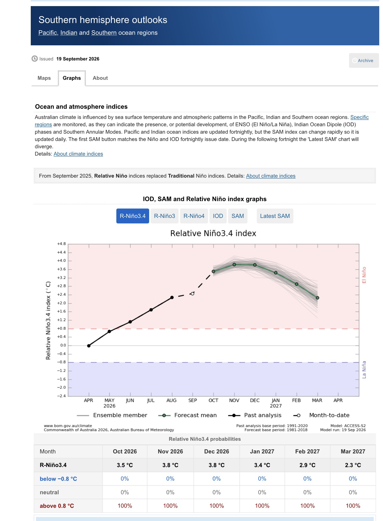
BOM updated with a +3.8C RONI. Might be too high, but it will easily get above +3C on the monthly mean.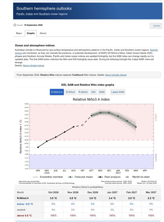
-
Septorcher 2026 Discussion - Endless Summer
SouthCoastMA replied to Damage In Tolland's topic in New England
Has to be over the weekend though, blows -
Septorcher 2026 Discussion - Endless Summer
ineedsnow replied to Damage In Tolland's topic in New England
0z ICON last night looked really good lets get that solution again -
Septorcher 2026 Discussion - Endless Summer
ineedsnow replied to Damage In Tolland's topic in New England
hoping for some big runs at 12z -

2026-2027 Record-breaking El Nino
PhiEaglesfan712 replied to Stormchaserchuck1's topic in Weather Forecasting and Discussion
1982-83 was a record breaking east based el nino that had a great back half of winter (February blizzard and mid-April snow/freeze event). -

Septorcher 2026 Discussion - Endless Summer
CoastalWx replied to Damage In Tolland's topic in New England
FWIW both euro and euro ai ensembles came NW. -
AAHHH finally...From GSP AFD this morning and for your reading pleasure At the same time, very broad sfc high pressure will park itself to our north over Ontario and Quebec helping to establish a cold-air damming wedge on Wednesday that will likely persist thru the end of the week. The resulting cool NELY flow and shower potential will help keep tempera- tures about 8 to 12 degrees below normal thru Friday. The wedge will likely weaken on Friday as the sfc low lifts further NE and drier air works its way into our area from the west. Nonetheless, temperatures are expected to remain below normal thru the weekend with shower chances diminishing each day from Thursday onward and increasing sunshine.
-

Septorcher 2026 Discussion - Endless Summer
Typhoon Tip replied to Damage In Tolland's topic in New England
Right... I mean I just mentioned to wise-ass ( lol ) that it's not physically impossible.. I just wasn't going to get into a whole UVM 'stokes discussion about why latent heat release lowers heights ... Question is, how much and does it really drill down an anchor a surface low that the Euro's near bombogen rates needs to be 72 hours out for my taste. We'll see The other thing ... something happened about 10 or 15 years ago with modeling, et al. The general technological behavior seemed to unilaterally reverse. What used to be missed in the late mid range, suddenly became over amplified in general ongoing dependable practice. We colloquially refer to this as 'model magnification' but it's not like that's not doing that anymore. It's still a real tendency/hasn't gone away. Not having substantive S/W input into the arena, then ending up with multiple contours ... mmm sort smacks as a candidate for that oversell routine. -

2026-2027 Fall/Winter Mountain Thread
BlueRidgeFolklore replied to BlueRidgeFolklore's topic in Southeastern States
Still looks much more seasonable for us, than what we've been dealing with. I can't say the say the same for the central Ohio Valley. -
trusted online pharmacy: BelvionPharmacy - trustworthy online pharmacy
-
Yep ended up with 1.32 here
-
Im walking in the Tunnels2Towers event on Sunday. As much as I want this storm to hit , I hope its a dry day.
-
Septorcher 2026 Discussion - Endless Summer
CoastalWx replied to Damage In Tolland's topic in New England
I noticed that too, it’s a subtle shortwave then all the sudden it deepens with multiple contours at H5. But I think that’s also in response to cyclogenesis too. We see that in winter a lot, only strong s/w and more closed contours at H5. I don’t necessarily have an issue how it’s modeled, it’s more the track and how each vort lobe location dictates where the low migrates to. -
Septorcher 2026 Discussion - Endless Summer
40/70 Benchmark replied to Damage In Tolland's topic in New England
I know, but I think I'd eventually have issues with it backing into Ginxy's dog kennel like that. -
Septorcher 2026 Discussion - Endless Summer
40/70 Benchmark replied to Damage In Tolland's topic in New England
Took the words right out of my mouth. -
Septorcher 2026 Discussion - Endless Summer
CoastalWx replied to Damage In Tolland's topic in New England
Obviously we are weenie projecting, but decent NNE ageo flow there with strong HP N and NW.