All Activity
- Past hour
-
 Buy Tadalafil 5mg Buy Tadalafil 20mg - Tadaliko
 -

Canada Storm-Specific SVR/TOR Warnings
vortex95 replied to vortex95's topic in Weather Forecasting and Discussion
Was delayed, now goes into effect 8/11/26. https://dd.meteo.gc.ca/doc/genots/2026/08/03/NOCN04_CWAO_031225___62572 -
One of the best weather days of the season. Going to have to wait awhile for another one as we will be back in the Sauna starting later Wednesday - with heat advisories likely and severe and flooding watches warnings to go along with it.
-
Order Viagra 50 mg online Buy generic 100mg Viagra online - buy viagra here
-
cialis generic - [url=https://tadaliko.shop/#]Tadaliko[/url] Tadaliko
-

2026-2027 Super El Nino
snowman19 replied to Stormchaserchuck1's topic in Weather Forecasting and Discussion
I get what you’re saying with adding an OHC component to the formula, but I think looking at it separately is just as effective - Today
-
2026-2027 Super El Nino
snowman19 replied to Stormchaserchuck1's topic in Weather Forecasting and Discussion
And the MEI cope has officially failed miserably, down in flames!! Womp, womp!! The last 5 months have been absolutely hilarious. Let’s see…First there was the RONI cope, FAIL, then there was the SOI cope, FAIL, then there was the trade winds are going to come back cope, FAIL, then there was the ridiculous Modoki cope, FAIL, then there MEI cope, FAIL, now we have the -PDO cope, also destined to miserably fail this fall. Can’t wait to see what the next copium will be to downplay the strongest east-based super El Niño in history…. Have to post this again….makes me smile -

2026-2027 Super El Nino
ensonerd1233e343 replied to Stormchaserchuck1's topic in Weather Forecasting and Discussion
tbf i have only been on here for a week but i will say the index has its flaws for starters theres only one eof so if an el nino has wwbs centered slightly east or west of typical or if the olr response is aytypical ( but still nino like) that can hurt the index i think adding a second mei w a second eof could be usueful but the third issue is the variables people act like its represntitve of the coupled system but the atmosphere counts for 4/5 of the index so its really an atmospheric index, secondly all indices counting the same is also a problem, im sorry "v wind" should not count the same as slp which has a very tight correlation to enso. Imo we shoud also add upper ocean heat conent and u componet of sfc current and remove v wind but i digress. Despite its flaws its still good at capturing the atmospheric response to enso it just needs to be looked at alongside the maps for slp winds olr vp to confirm super nino coupling. So when ppl discredit it there could be a reason im not saying they are correct tho. -

2026-2027 Super El Nino
so_whats_happening replied to Stormchaserchuck1's topic in Weather Forecasting and Discussion
I would be pissed if this dude kept tagging me in everything. -
2026-2027 Super El Nino
snowman19 replied to Stormchaserchuck1's topic in Weather Forecasting and Discussion
The coupling is extreme. Biggest April - July MEI rise in history, like you said, up to +2.4 now. The highest MEI value we’ve had since 1998 and only 0.5 from the all time record of +2.9: -
 Chesco, you are quite welcome. Seems like an important step towards understanding the data adjustments done by NCEI and BEST, and the topic of this forum.. The next step is to look at how break points are identified using reference stations. Chubbs has a graph above showing the 1946 break resulting from 1 SW's move to Newlinville, and here is similar graph also using raw data. What I have done is synchronize the temperature series at 1945, and removed the absolute temperature values on the Y-axis--because the absolute values don't matter if we are looking for climate trends. This shows just the 1946 break, and shows the RESULT/IMPACT the station move made on Tavg. Now, imagine repeating this process with a large set of reference stations across the whole history of 1 SW to create a time line of breaks and the deg F size of the shift at each break. That is what is done. With the new information from the breaks, we can adjust the station data by reversing the IMPACT of the moves. With the repaired data set, we can then identify baselines and departures from those baselines--anomalies. Absolute values don't matter, the change over time does. Also, by convention the adjustments are made with the end of the raw data series aligned to the same temperature as the end of the adjusted data series. This may lead to confusion when the raw and the adjusted data are viewed in the same graph, because it looks like one series has been "chilled" or "warmed" with respect to the other. The reality is that the raw data for Coatesville is actually several distinct stations, and the adjusted data has been upgraded to be a lot closer to what the raw data would have looked like if the station never moved. Trying to assign absolute temperatures to either time series is not useful when the information we want is change over time. With that in mind, would you clarify what you mean by "there were no unusual temperature changes at Coatesville 1SW that were not statistically aligned with the nearby stations within 30 miles of that point" & "This supports the fact that there was no need for any adjustments to the raw data at all!"?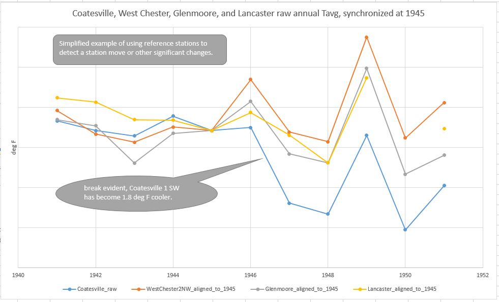
-
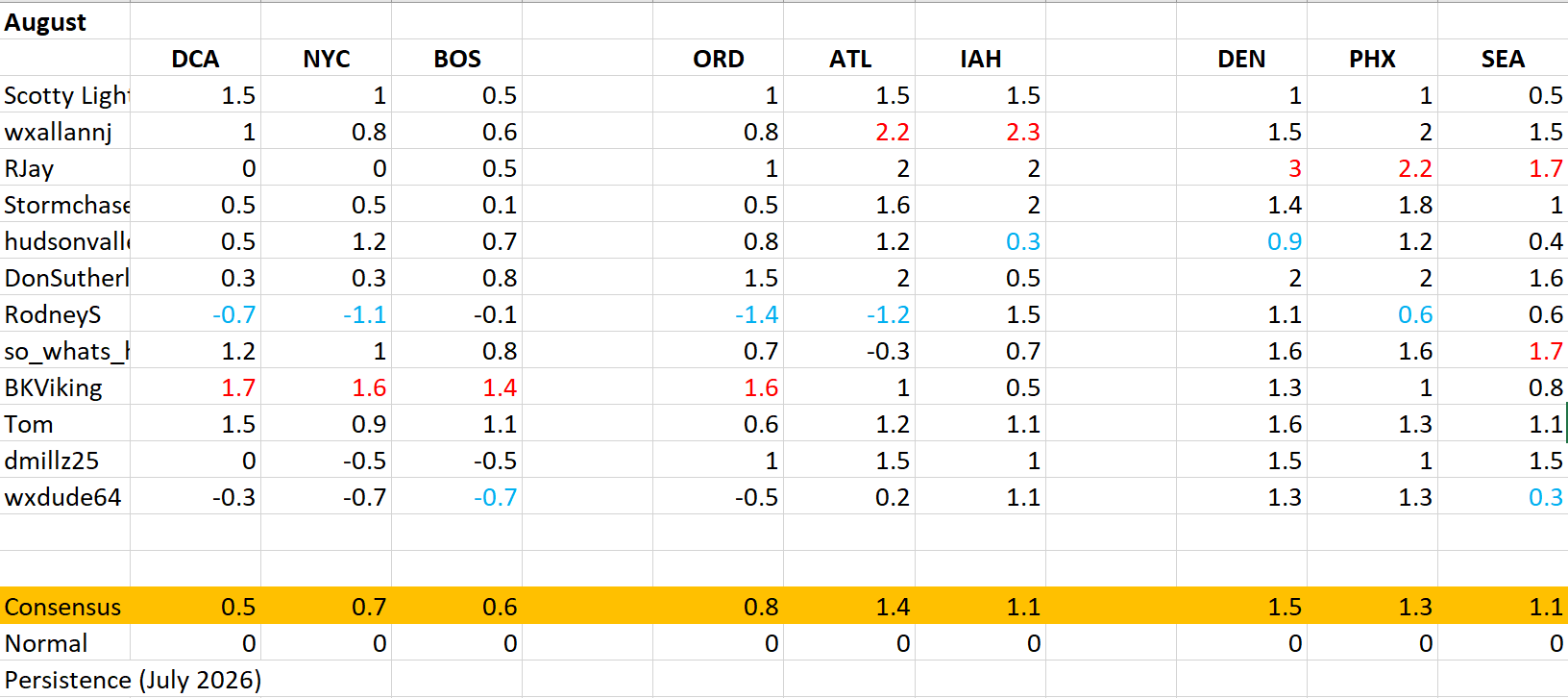
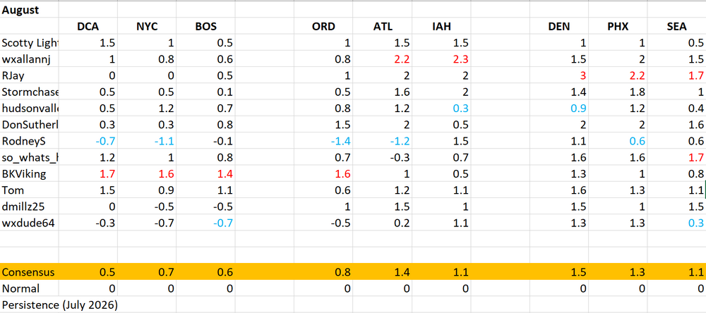
Sorry for the delay here is August. I think I want to try adding persistence into the new year. I will base it off of a 6 month running mean of the actual anomalies. If anyone has criticisms on this please feel free to let me know how best to approach something like this.
-

Augdewst 2026: Summer's Last Stand
HIPPYVALLEY replied to Prismshine Productions's topic in New England
Good weather watching opportunities doing a route like that. -
Short Term / High Res Guidance is fairly confident in redevelopment more locally after midnight, that's what the FFWatch is for.
-
Augdewst 2026: Summer's Last Stand
vortex95 replied to Prismshine Productions's topic in New England
Came across this site. Excellent current stats and ranking for global TCs! https://global-tropical-cyclones.com/ And I got a better list of the top TCs globally by ACE. For some reason they counted Paka from 1997 twice. I think b/c the storm formed in the cntrl Pacific and crossed into the wrn Pacific. So really #20 on the list should be Lola from the NWPAC in 1957. This site from CSU is also excellent for S-T-D activity and archives. https://tropical.atmos.colostate.edu/Realtime/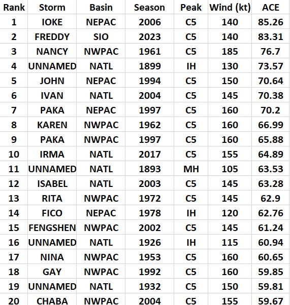
-
2026-2027 Super El Nino
so_whats_happening replied to Stormchaserchuck1's topic in Weather Forecasting and Discussion
Now I understand, we use MEI now that it has finally caught up but before it was discredited as a metric because it was not showing what people wanted. This thread gets more funny by the day. I feel I should just create a twitter account based off this. -
It has become a very large typhoon, which is to be expected w/ a system around this long gradually moving out of the tropics, but the inner core reforming like that w/ a smaller eye that a few days ago is surprising. The other day the eye was about 35 nm in diameter, but now about 20 nm. We still have another 5 days before landfall, so it may form a giant eye yet. Fcst to pass right over Okinawa. Three METAR sites to look at for Okinawa for the passage -- RODN, ROTM, and ROAH. It's too bad the WSR-88D at RODN was decommissioned a few years ago!
-
2026-2027 Super El Nino
so_whats_happening replied to Stormchaserchuck1's topic in Weather Forecasting and Discussion
The one you seem to be discrediting has actually been more negative than the one you posted. 2020 -1.41 -1.48 -1.75 -1.32 -0.52 -0.75 -0.92 -1.33 -1.04 -0.62 -1.58 -0.98 2021 -0.61 -1.09 -1.67 -1.84 -2.04 -1.82 -2.00 -0.95 -1.96 -3.14 -2.75 -2.71 2022 -2.40 -1.91 -1.67 -2.09 -2.23 -1.31 -2.63 -2.38 -2.28 -1.81 -2.40 -2.21 2023 -1.24 -1.65 -2.45 -3.08 -2.41 -2.55 -2.54 -2.48 -2.99 -2.23 -1.79 -1.66 2024 -1.57 -1.34 -1.54 -2.11 -2.98 -3.15 -3.01 -2.91 -3.56 -3.80 -3.13 -2.03 2025 -1.29 -1.40 -1.12 -1.15 -1.66 -2.64 -4.21 -3.23 -2.31 -2.37 -1.51 -0.96 2026 -1.24 -1.00 -1.42 -1.62 -1.67 -1.71 -2.03 99.99 99.99 99.99 99.99 99.99 https://www.ncei.noaa.gov/pub/data/cmb/ersst/v5/index/ersst.v5.pdo.dat Versus 2020 -0.79 -1.12 -1.68 -1.32 -0.68 -0.86 -0.77 -0.85 -0.75 -0.29 -1.23 -0.92 2021 -0.73 -1.29 -1.70 -1.77 -2.33 -1.89 -1.93 -0.84 -1.70 -2.69 -2.37 -2.47 2022 -2.22 -1.72 -1.63 -2.19 -2.44 -1.42 -2.44 -1.78 -1.78 -1.48 -1.83 -1.85 2023 -1.24 -1.79 -2.50 -3.13 -2.46 -2.67 -2.44 -2.02 -2.52 -1.88 -1.16 -1.20 2024 -1.48 -1.33 -1.27 -1.99 -3.01 -2.93 -2.62 -2.37 -3.10 -3.24 -2.58 -1.57 2025 -0.97 -1.20 -0.81 -1.07 -1.84 -2.62 -3.83 -2.54 -1.71 -1.82 -1.02 -0.39 2026 -0.87 -0.79 -1.18 -1.28 -1.64 -1.32 -1.29 99.99 99.99 99.99 99.99 99.99 https://www.ncei.noaa.gov/pub/data/cmb/ersst/v5/v6/index/ersst.v6.pdo.dat This one is the one that site uses. -
The white hot Red Sox just kicked their asses. Incredible turn around for them. They could win the pennant, as weak as the AL is.
-
Started with .07" today and then that one line just developed a miles or two to my north so we missed out on some good rains there. But just now this little guy has popped up and has pushed my rainfall to .18" as its raining pretty good from it.
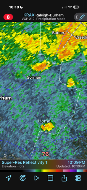
-
Picked up a nice .86 this evening. Very surprised with only a 15% chance of rain.
-

Winter 2026-2027 Seasonal Outlook
Prismshine Productions replied to WinstonSalemArlington's topic in Southeastern States
[emoji445]Oh, Momma, I'm in fear for my life from the long arm of the law... Lawman has put an end to my runnin', and I'm so far from my home... Oh, Momma, I can hear you a'cryin; you're so scared and all alone... Hangman is comin' down from the gallows, and I don't have very long... Sent from my SM-S176V using Tapatalk -
Dodgers losing to the Cubs right now, love to see it.
-
Looks to be a quiet night and morning. Next
-
Yeah, FW’s aren’t going to verify.