All Activity
- Past hour
-

Central PA Summer 2026 Discussion/Obs Thread
canderson replied to Voyager's topic in Upstate New York/Pennsylvania
Headed to Baltimore thus afternoon to see the Sox; very appreciative of the lowering dew and low-to md 80s highs! -
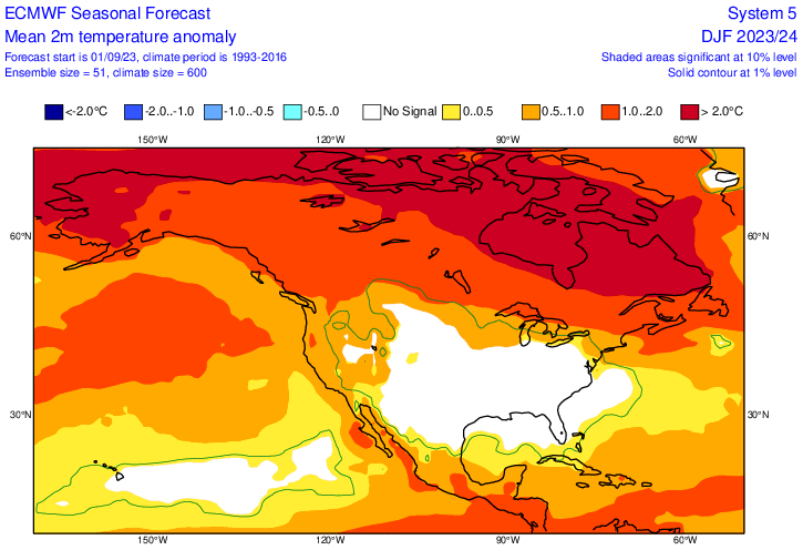
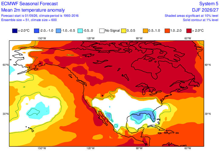
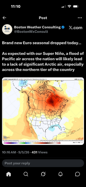
Comparison of Sept ‘23 Euro for DJF 23-4 and Sept ‘26 for DJF 26-7: ’23: ‘26:
-

Winter 2026-2027 Seasonal Outlook
WinstonSalemArlington replied to WinstonSalemArlington's topic in Southeastern States
-

Septorcher 2026 Discussion - Endless Summer
Great Snow 1717 replied to Damage In Tolland's topic in New England
For this site getting you is like Red selecting Bird with the 6th pick in the 1978 draft!! You future enshrinment into the AMWX Hall of Fame is a lock!! -
yea i remember that---we were laughing at how we needed the pattern to go nina for us to score snow during that Nino. That season, canada was so blowtorched that we could never recover. but the models looked really good in the fall looking ahead to that winter. Thats the scary part
-
86 this morning. Low of 76
-
Trend this month is warmer....hope it's wrong.
-
Interesting + PNA phase might happen
-
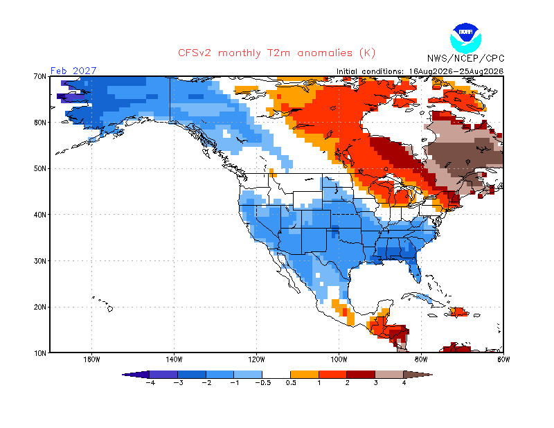
Will, thanks for posting. Unfortunately, WB CFS temp. maps have major algo flaws and thus I rarely post them. Example: they usually have a major cold spot over S Lake Michigan and a major warm spot over N L. Mich & vicinity just 250 miles to the N! Also, they tend to have too much contrast between well inland areas of the E 1/2 of the US (too cold) and the much warmer near E coast (often too warm). Related to this, WB shows at/near record cold Feb/Mar of -5 to -7C (and even vs the colder 1981-2010 climo!) in those areas with the 3rd-6th shades of green based on the means of 30 days of runs. The CFSv2 site shows nothing of the sort: examples for Feb: 1) Columbus, GA, in Feb is ~-3.5C vs 1991-2020 for the avg of the 3 maps below from the CFSv2 site, itself, whereas WB has them ~-5C vs the colder 1981-2010 or ~2C/3.6F too cold (1991-2020 is 0.5C warmer than 1981-2010). 2) At the same time, the NC/VA border on E coast in Feb is ~-1.5C vs 1991-2020 on CFSv2 compared to NN on WB vs the colder 1981-2010 meaning WB is ~1C too warm 8/6-15: 8/16-25: 8/26-9/4:
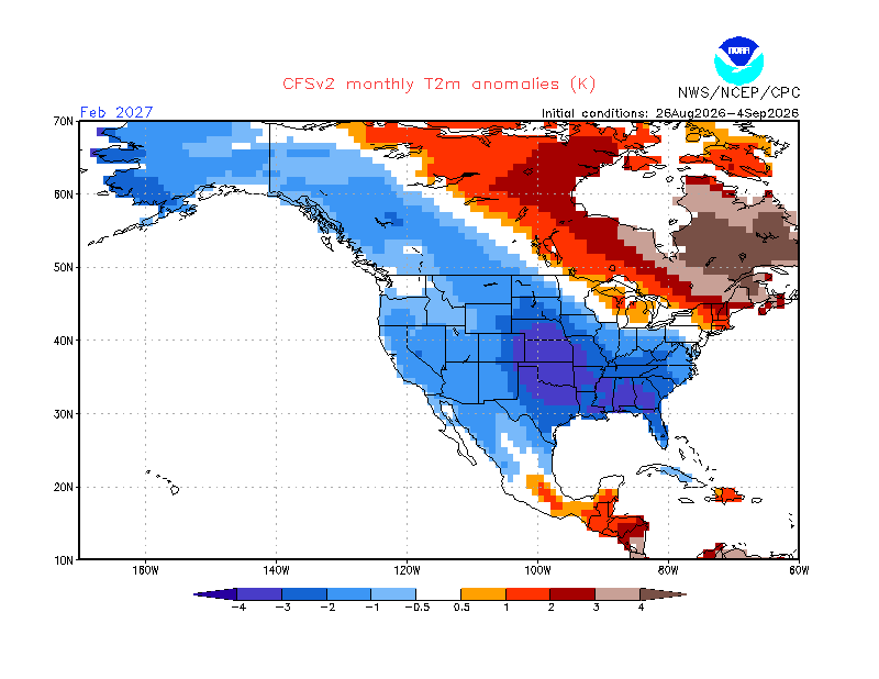
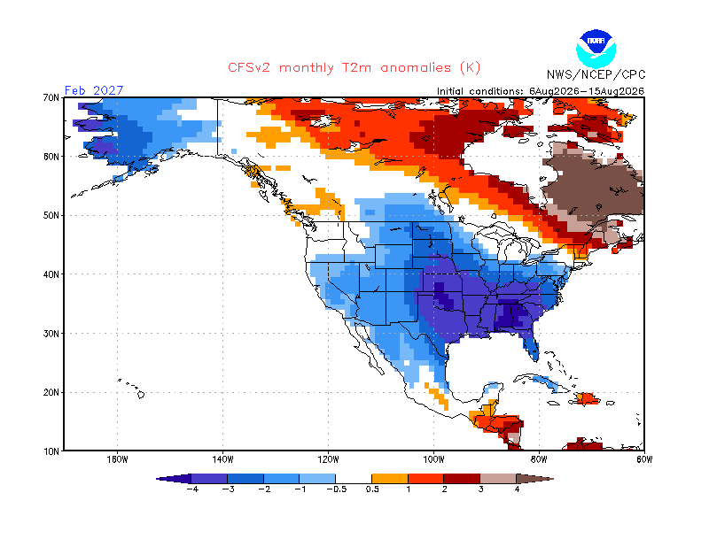
-
We are entering a dry period during the next 7 days, unless the Thursday system delivers which is unlikely at this time. At least we are losing solar heating and the days are getting shorter.
-
Hideous look with Aleutian low over AK and massive + EPO. Open the torch Pacific floodgates if this happens
-
The cruel irony of 23-24 is that when it snowed, it was from northern stream systems squeezed under the canadian block at a time when the STJ took a break. When the STJ was active, it was rain every time. Cape Breton did get buried under 5 feet of snow in one storm thanks to the STJ, so at least there’s that.
-
 buy misoprostol over the counter: cytotec abortion pill : cytotec abortion pill
 -
this dosent look that much different from the euro seasonal for 23-24 and that was a disaster but on paper it looked good. I see a lot of people on twitter in England are super excited because they say this shows a very strong -NAO signtature but i would like that red further north
-

Central PA Summer 2026 Discussion/Obs Thread
Blizzard of 93 replied to Voyager's topic in Upstate New York/Pennsylvania
Refreshing dew points are here! -
This was the light show in the clouds before I got that shot: https://www.facebook.com/reel/1085227447341802
-
http://hairguardrx.shop/# cost of cheap propecia online
-

2026-2027 Record-breaking El Nino
MJO812 replied to Stormchaserchuck1's topic in Weather Forecasting and Discussion
Yep nice stj train. How do you know it shows 10 inches ? People need to stop making statements. 1 storm can do wonders. -

Septorcher 2026 Discussion - Endless Summer
WxWatcher007 replied to Damage In Tolland's topic in New England
My God, the GFS. -
http://hairguardrx.shop/# cost of cheap propecia online
-
http://nolvacare.shop/# tamoxifen mechanism of action
- Today
-
http://hairguardrx.shop/# cost of cheap propecia online
-
Winter 2026-2027 Seasonal Outlook
WinstonSalemArlington replied to WinstonSalemArlington's topic in Southeastern States
Ripe for Miller As? -
Gotcha Jeff the spc now has almost all of middle TN and east TN in marginal risk and slight risk for northern portion of east TN for 5-15% damaging winds and 5% hail also ikr also can’t forget about all of that and the iss haven’t seen anything about the northern lights or anything else yet .
-
Just got power back from the storm that came thru yesterday around 6 pm. Had some pea to 1/2" sized hail, a 39 mph gust and 0.32" here, but LOTS of damage pics coming in on facebook. Trees down, powerlines down and several roofs and sheds either blown over/off or damaged. Currently have thunder/lightning and light rain from a dying line moving thru from WV, temp 68.8/66.9 at 10:30 am. Looking at Dominion's outage map, still 800+ without power in the county.