All Activity
- Past hour
-

Septorcher 2026 Discussion - Endless Summer
ineedsnow replied to Damage In Tolland's topic in New England
Starting to look great here! -
Yeah finally a turn for the better.
-

Septorcher 2026 Discussion - Endless Summer
Snowedin replied to Damage In Tolland's topic in New England
Weird, hardly any noticeable foliage here aside from the leaves having a more faded look. That’s probably mostly to do with having a fairly dry summer. I’m sure within a couple weeks we’ll start seeing the change. New England's many micro climates and eco diversity is always fascinating to witness. -
 online ed medication: Apex Men Meds - cheap ed treatment
 -

2026-2027 Record-breaking El Nino
GaWx replied to Stormchaserchuck1's topic in Weather Forecasting and Discussion
Due to the timing of the upgrade, I’m also quite suspicious that this Euro 5/12/26 upgrade MAY have contributed to the colder 2026 vs previous summers. So, I do see what you’re saying. Thats why I went to that other forum and spent a couple of hours to see if anyone pointed to that. But nobody did in those hundreds of posts from very knowledgeable folks, including very experienced pro-mets. If this Euro upgrade is really a contributor or possibly even the main cause, don’t you think at least one person there would have mentioned that? That’s why I’d prefer to keep an open mind until there’s decent agreement among the met. community. Do you see anything wrong with that? You may be right and you’d then deserve major kudos, but I’d first Iike to see some consensus. But even if you’re right, can’t 2026 still be a cold outlier but to a lesser extent? -
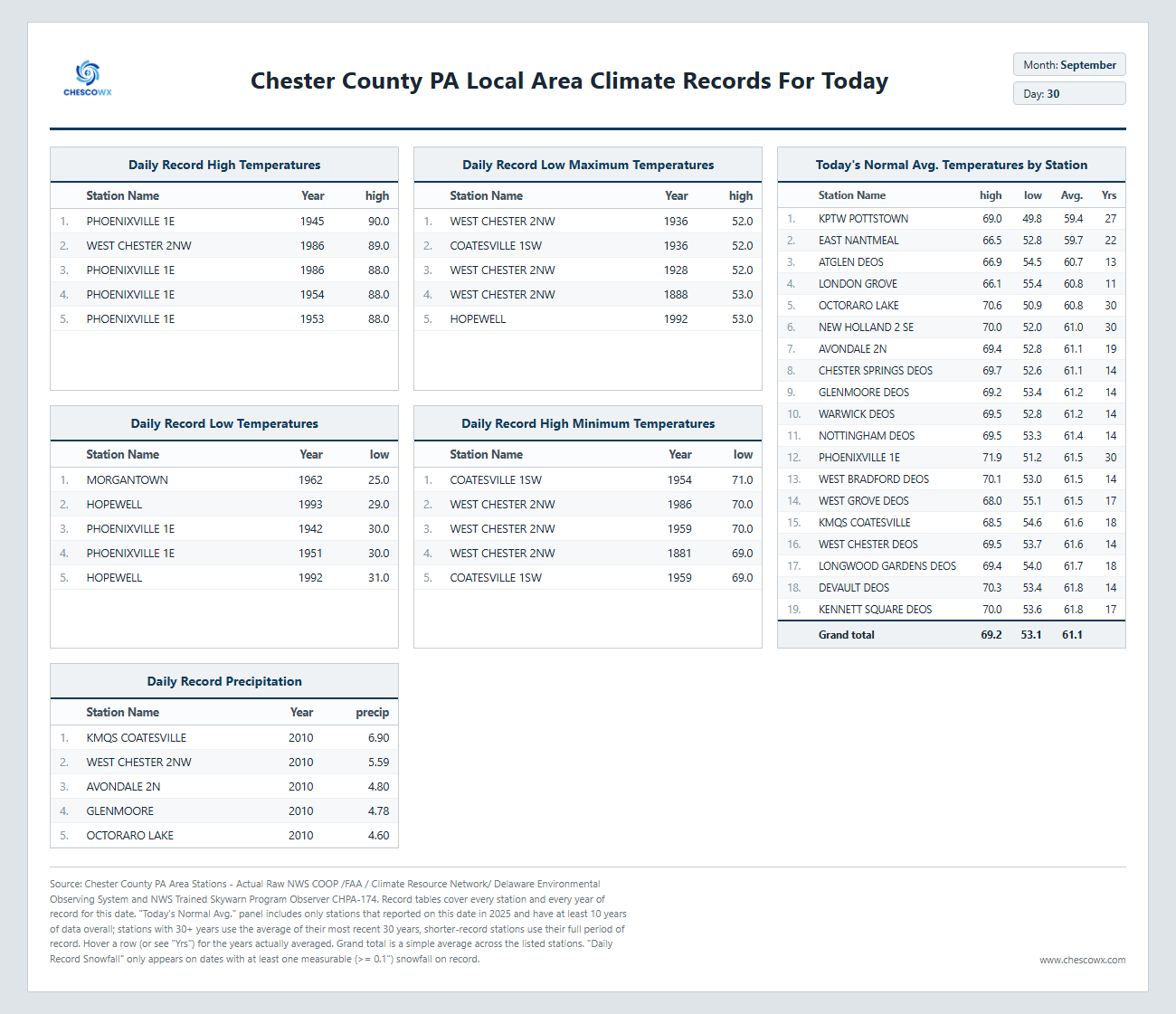
September 30 1995: Lightning starts a house on fire in Washington County. 1985: 4 inches of snow falls in Ely, with just a trace in the Twin Cities. For Wednesday, September 30, 2026 1896 - A hurricane formed on September 22 and lasted until September 30. It formed directly over the Lesser Antilles and hit Cuba, Florida, Georgia, South and North Carolina, Virginia, Washington D.C., and Pennsylvania. Its maximum sustained winds were at 130 mph. The heaviest rainfall deposited in association with the storm was 19.96 inches at Glennville, Georgia. This hurricane was responsible for an estimated 130 deaths and $1.5 million in damage (1896 dollars). 1959 - Three tornadoes spawned by the remnants of Hurricane Gracie killed 12 persons at Ivy VA. (The Weather Channel) 1970 - A nineteen month drought in southern California came to a climax. The drought, which made brush and buildings tinder dry, set up the worst fire conditions in California history as hot Santa Anna winds sent the temperature soaring to 105 degrees at Los Angeles, and to 97 degrees at San Diego. During that last week of September whole communities of interior San Diego County were consumed by fire. Half a million acres were burned, and the fires caused fifty million dollars damage. (David Ludlum) 1977 - The temperature at Wichita Falls, TX, soared to 108 degrees to establish a record for September. (The Weather Channel) 1986 - Thunderstorms, which had inundated northern sections of Oklahoma with heavy rain, temporarily shifted southward producing 4 to 8 inches rains from Shawnee to Stilwell. Baseball size hail and 80 mph winds ripped through parts of southeast Oklahoma City, and thunderstorm winds caused more than half a million dollars damage at Shawnee. (Storm Data) 1987 - Afternoon thunderstorms in Michigan produced hail an inch in diameter at Pinckney, and wind gusts to 68 mph at Wyandotte. A thunderstorm in northern Indiana produced wet snow at South Bend. Seven cities in the northwestern U.S. reported record high temperatures for the date, including readings of 98 degrees at Medford OR and 101 degrees at downtown Sacramento CA. (The National Weather Summary) (Storm Data) 1988 - Unseasonably warm weather prevailed over Florida, and in the western U.S. The afternoon high of 94 degrees at Fort Myers FL was their tenth record high for the month. Highs of 98 degrees at Medford OR and 99 degrees at Fresno CA were records for the date, and the temperature at Borrego Springs CA soared to 108 degrees. (The National Weather Summary) 1989 - Thirteen cities reported record high temperatures for the date, as readings soared into the upper 80s and 90s from the Northern and Central High Plains Region to Minnesota. Bismarck ND reported a record high of 95 degrees, and the temperature reached 97 degrees at Broadus MT. Afternoon thunderstorms developing along a cold front produced wind gusts to 60 mph at Wendover UT. (The National Weather Summary) (Storm Data) Observances: 30 Wed International Podcast Day 30 Wed National Love People Day 30 Wed International Translation Day 30 Wed World Maritime Day 30 Wed National Day for Truth and Reconciliation 30 Wed Blasphemy Day 30 Wed Extra Virgin Olive Oil Day 30 Wed National Chewing Gum Day 30 Wed National Hot Mulled Cider Day 30 Wed National Mud Pack Day 30 Wed National Puppy Mill Survivor Day 30 Wed Pet Tricks Day
-
rain classic
-

Septorcher 2026 Discussion - Endless Summer
Brian5671 replied to Damage In Tolland's topic in New England
2 days of mostly sunny forecasts I think I've seen the sun maybe 2 hrs -
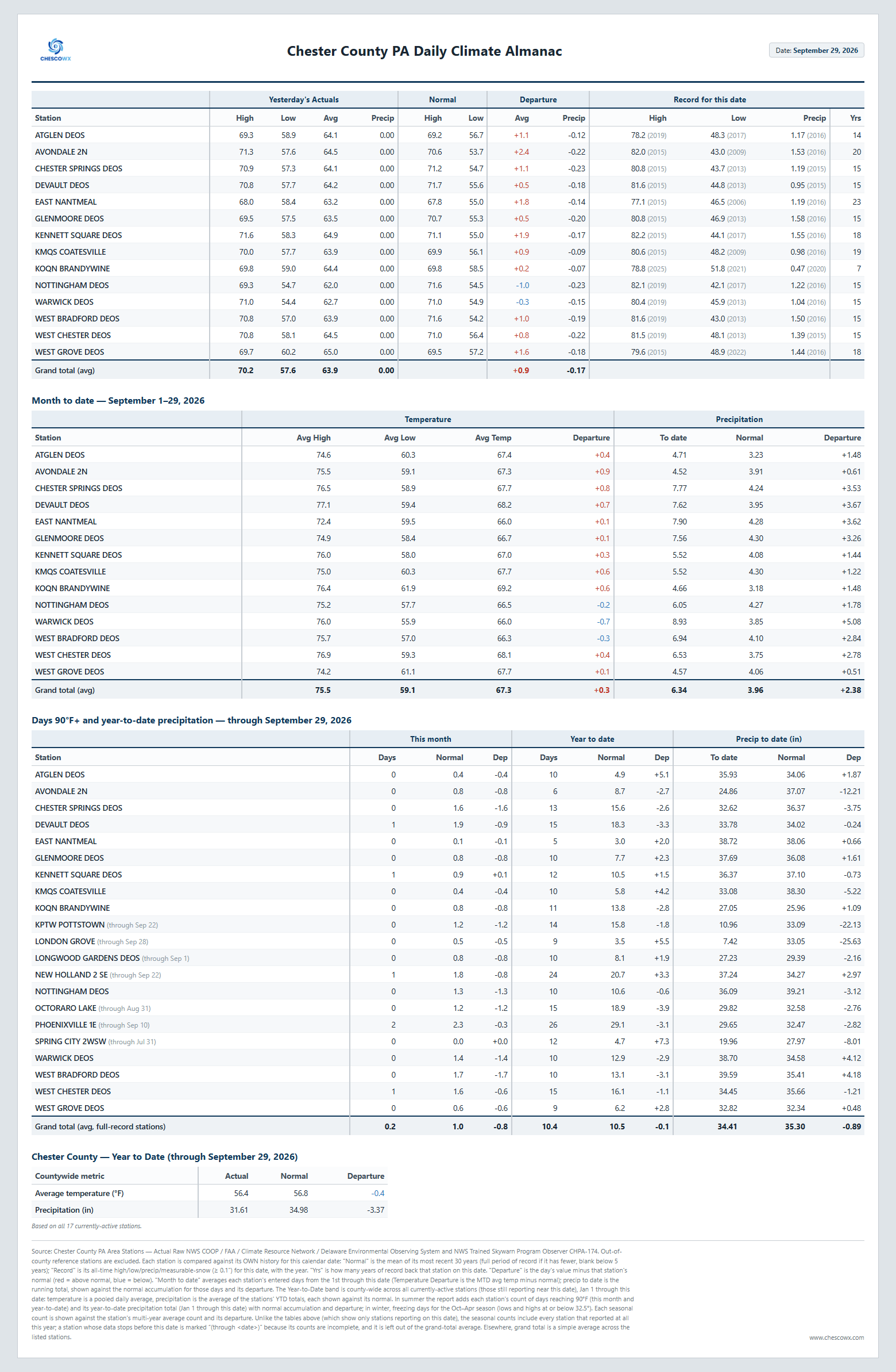
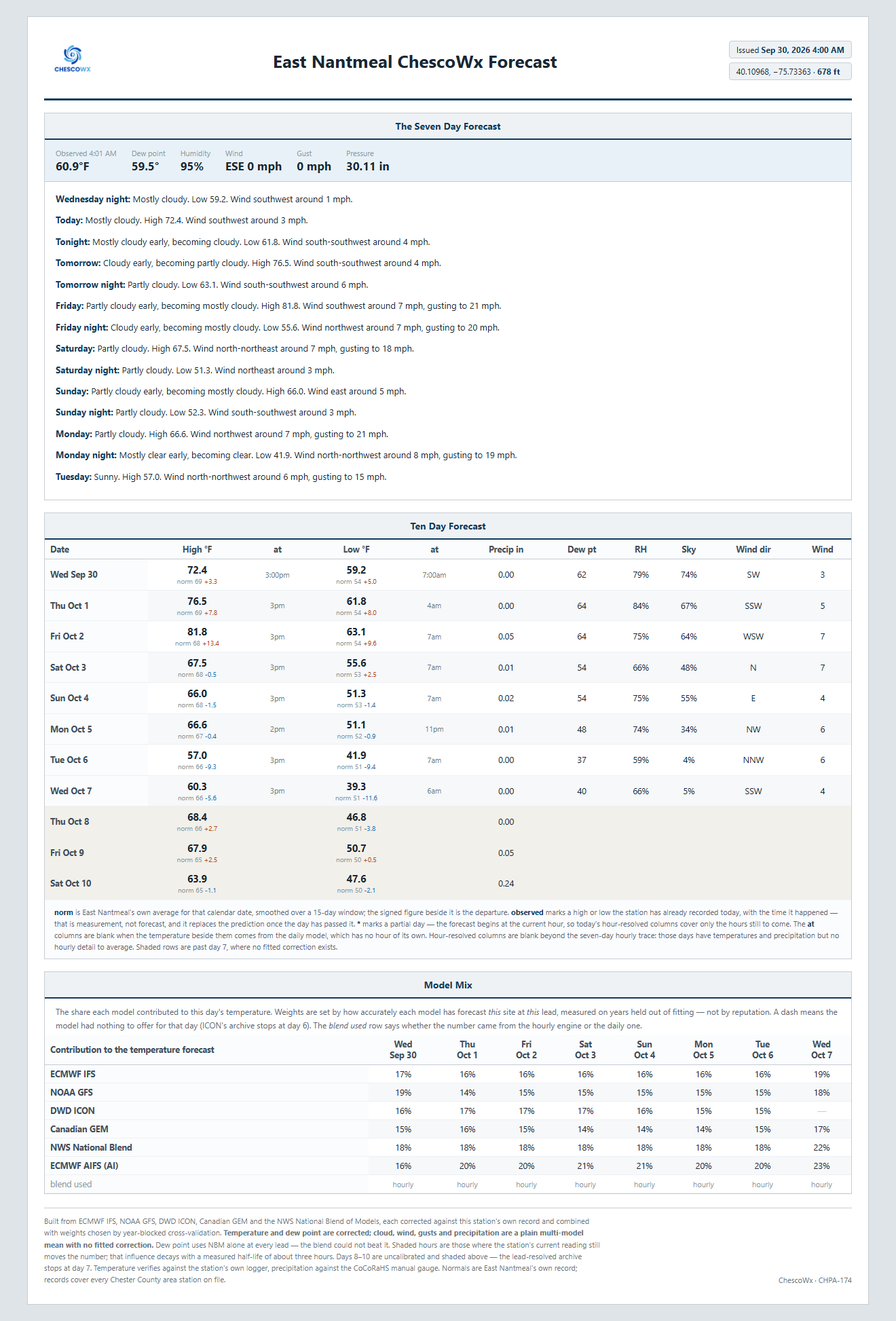
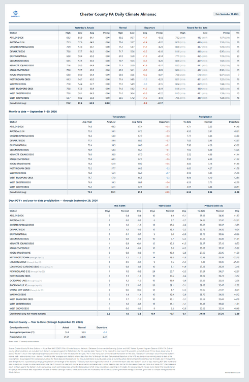
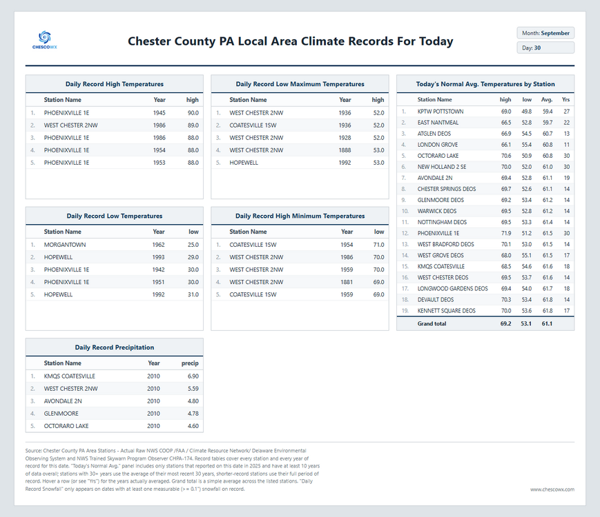
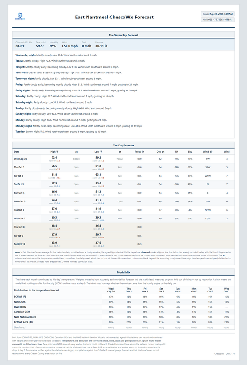
We continue to see a nice warming trend today through Friday. Temperatures by Friday could touch the 80's for what will likely be our last time for most spots till next April or May. We turn sharply chillier over the weekend and especially next week. Highs by next Tuesday will remain in the chilly 50's with nighttime lows down into the 30's with the potential of a frost or freeze across some of our typically colder valley locations by Wednesday morning.
-
(002).thumb.png.6e3d9d46bca5fe41aab7a74871dd8af8.png)
E PA/NJ/DE Autumn 2026 Obs/Discussion
ChescoWx replied to PhiEaglesfan712's topic in Philadelphia Region
We continue to see a nice warming trend today through Friday. Temperatures by Friday could touch the 80's for what will likely be our last time for most spots till next April or May. We turn sharply chillier over the weekend and especially next week. Highs by next Tuesday will remain in the chilly 50's with nighttime lows down into the 30's with the potential of a frost or freeze across some of our typically colder valley locations by Wednesday morning.
-
2026-2027 Record-breaking El Nino
GaWx replied to Stormchaserchuck1's topic in Weather Forecasting and Discussion
Because the plot he posted was for May-Aug, I’ll analyze that period. Looking at the image below, May-Aug averaged ~1.3C, not ~2C, below the much older 1958-2002 climo: May was ~-2C, June was ~-2C, July was ~-1C, and Aug was ~-0.1C. This means ~-1.3C for the avg of May-Aug rather than -2C. However, I do realize that -1.3C vs 1958-2002 would be a good bit more negative vs 1991-2020….perhaps as much as ~-3C?? So, that would be colder than what that 925 mb anomaly map suggests for 80N+, which I roughly estimate to be -1.25C: However, that image is for 925 mb, not 2m. Isn’t it possible that the 2m anom was colder than the 925 mb anom?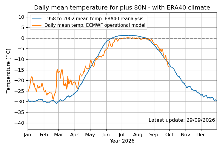
-
ed medications cost and buy ed meds online erectile dysfunction pills https://clients1.google.ac/url?q=https://apexmenmeds.com online ed prescription and http://ussher.org.uk/user/xdhtsajkav/?um_action=edit cheap erectile dysfunction pills [url=https://mclast.de/redirect/?url=http://apexmenmeds.com]where to buy erectile dysfunction pills[/url] ed drugs online and [url=http://sotoycasal.com/user/xkeaycfgwv/]online ed medication[/url] top rated ed pills
-
ed medications cost and buy ed meds online erectile dysfunction pills https://clients1.google.ac/url?q=https://apexmenmeds.com online ed prescription and http://ussher.org.uk/user/xdhtsajkav/?um_action=edit cheap erectile dysfunction pills [url=https://mclast.de/redirect/?url=http://apexmenmeds.com]where to buy erectile dysfunction pills[/url] ed drugs online and [url=http://sotoycasal.com/user/xkeaycfgwv/]online ed medication[/url] top rated ed pills
-
ed medications cost and buy ed meds online erectile dysfunction pills https://clients1.google.ac/url?q=https://apexmenmeds.com online ed prescription and http://ussher.org.uk/user/xdhtsajkav/?um_action=edit cheap erectile dysfunction pills [url=https://mclast.de/redirect/?url=http://apexmenmeds.com]where to buy erectile dysfunction pills[/url] ed drugs online and [url=http://sotoycasal.com/user/xkeaycfgwv/]online ed medication[/url] top rated ed pills
-
Judging by the positioning of the ridge and the expected timing of the front, Friday AM looks like a good time. I would say the best time is Thursday evening, so whatever works best for your schedule. Definitely want to do it before the weekend.
-

Septorcher 2026 Discussion - Endless Summer
dendrite replied to Damage In Tolland's topic in New England
I mowed the pawpaw and chestnut area once in the early spring and that has been it. There’s a little meadow back there now with clover, goldenrod, and aster. The crickets have been insane. -

Septorcher 2026 Discussion - Endless Summer
alex replied to Damage In Tolland's topic in New England
That’s why I like the pre-peak period. The contrast is much better than when it’s all orange and red in my opinion. Except for areas with lots of pines mixed in, obviously those always have good contrast. I imagine we’ll be past peak by next week but hopefully the colors last a bit -
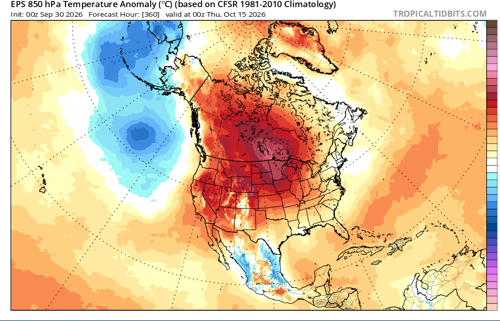
p big ridge signal in fantasy range on the eps
-
 DCA: +0.9 NYC: +0.8 BOS: +0.8 ORD: +1.1 ATL: +1.2 IAH: +1.4 DEN: +1.6 PHX: +1.5 SEA: +2.1
 - Today
-

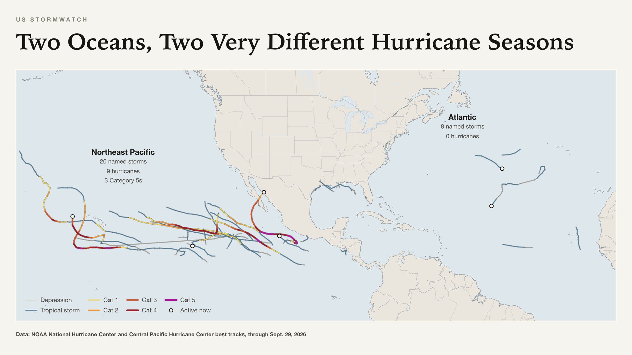
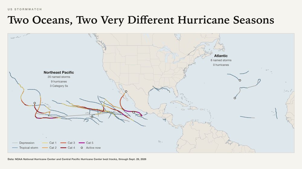
2026 Atlantic Hurricane Season
olafminesaw replied to Stormchaserchuck1's topic in Tropical Headquarters
-
We had an inch of snow on October 10, 1979. December was warm, but there were some okay snowfalls the rest of the winter. March 1 had eight inches and IAD's high was 17!!
-
Trying to get a mow in today and Friday morning before overseeding and areation. You think Friday morning looks good for a second lower cutting prior to areation? Going in to work at 2:00 PM today. Yeah and here is exactly what you mentioned.
-
Tadalafil Tablet: TadaStream Rx - Buy Tadalafil 5mg
-
Cheap generic Viagra online or Cheap generic Viagra online viagra canada https://maps.google.co.zm/url?q=https://sildendirect.com Cheap Sildenafil 100mg and https://gikar.it/user/iuiqvoudpt/ buy Viagra over the counter [url=https://clients1.google.com.vc/url?q=https://sildendirect.com]Order Viagra 50 mg online[/url] Viagra online price or [url=http://www.iawbs.com/home.php?mod=space&uid=988364]viagra without prescription[/url] order viagra
-

Septorcher 2026 Discussion - Endless Summer
Typhoon Tip replied to Damage In Tolland's topic in New England
some of the model cloud/RH products might have been a bit optimistic ... Hi res vis suggests we suffer lowering sun angle and now less able to thermally induce erosion, because there's really nothing above about 1,000 feet elevation but the moon so the sun must be like skipping off the pond so to speak... there's some sky lights just beginning to open. If this were May we'd be full sun. the sounding would shoot us to 82 already but this late in the year and time today getting eaten by cool saturation at 900 feet should limit us under potential - a seasonal feedback mechanism.