All Activity
- Past hour
-
2020 had that supercell that ripped across southwester/southern CT (think august 26th or 27th). Outside of some very localized damage it's been a bore since the 2018 event. Was it two summers ago (maybe three) where we had a decent stretch I think in July with storms...nothing crazy but it was active.
-
We had a good event two years ago late month. Of course I missed it, but we had wind damage here. Overall though I feel like it's been quiet.
-

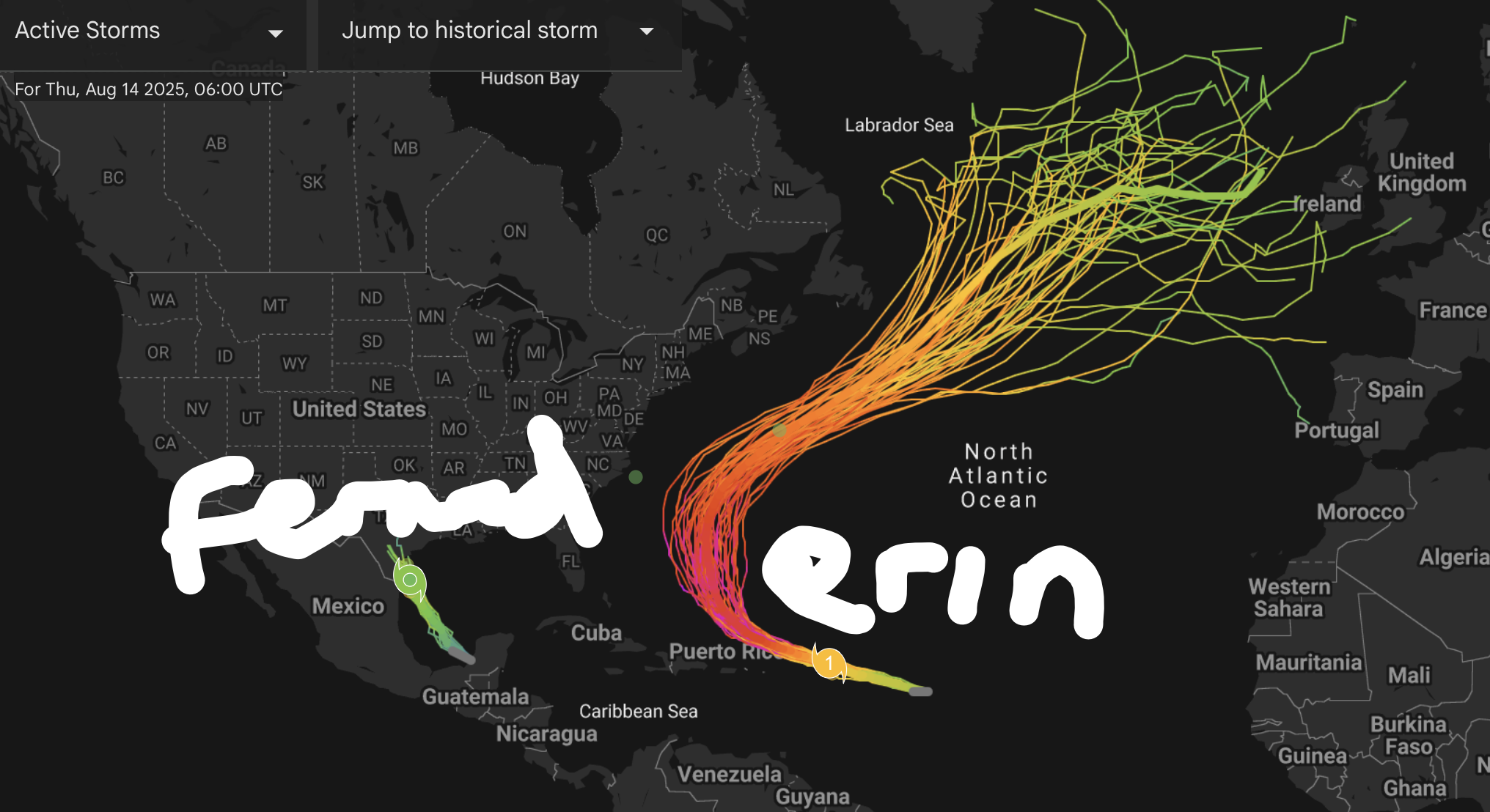
BAY OF CAMPECHE 98L NOW UP TO 20/20
WxWatcher007 replied to BarryStantonGBP's topic in Tropical Headquarters
Although it's convectively active, it doesn't look particularly organized and time is a huge limiting factor. It's a low shear environment and the BoC so we'll see if that helps organize this faster into a TC. We'll know more should recon fly today at 18z. -
Yeah, that is my early guess based on past multiyear La Ninas since the late 90s. There is usually one year with a strong +PNA December mismatch. The other surrounding Decembers had either a weaker positive or a negative PNA. So I will go lower on the PNA for December 2025 than the +1.70 we had in December 2024. But not sure yet whether it’s just a weaker positive or the PNA dips negative. Multiyear La Ninas and December PNA 2025…….? 2024….+1.70 2022….-0.66 2021….-2.56 2020…+1.58 2017…..+0.89 2016….-0.35 2011….+0.36 2010….-1.78 2008….-1.41 2007…..+0.14 2000…..+1.23 1999…..+0.21 1998…..-0.09
-

BAY OF CAMPECHE 98L NOW UP TO 20/20
BarryStantonGBP replied to BarryStantonGBP's topic in Tropical Headquarters
OI LADS YOUS COULD GET A LASTMINUTE.COM CATEGORY 1 INTO TEXAS INNIT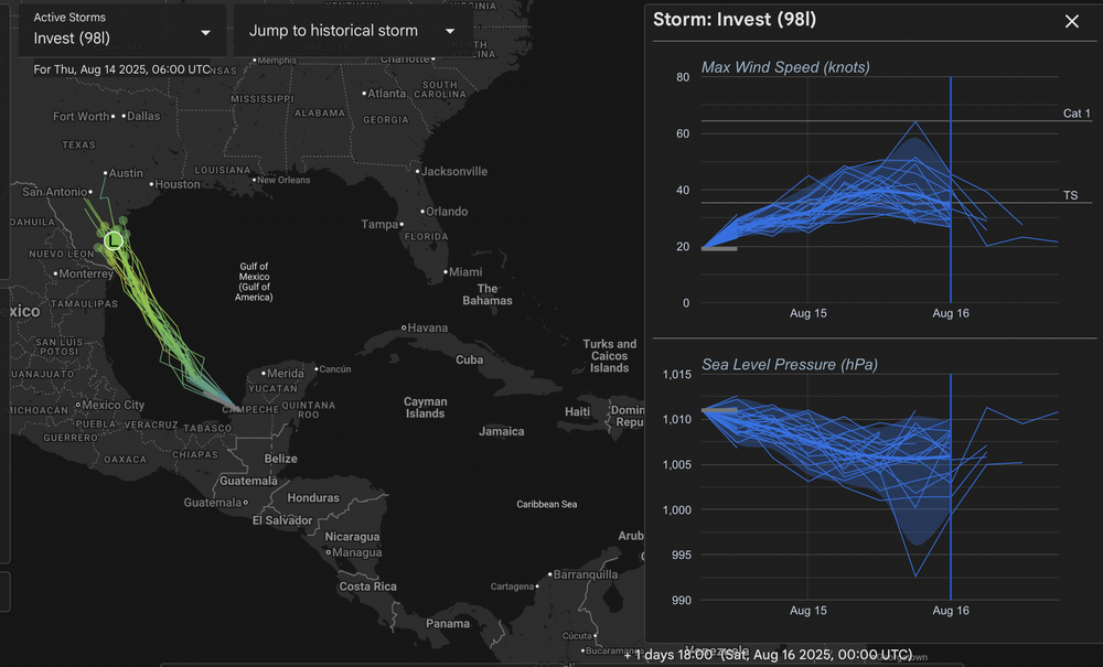
-
2025 Atlantic Hurricane Season
BarryStantonGBP replied to BarryStantonGBP's topic in Tropical Headquarters
DEEPMINDS UPDATE: Erin expected to peak as a Cat 3-4, safe recurve for the CONUS but Bermuda needs to watch out "Fernand" remaining a weak TS into TX (98L) and could be a category 1 "Gabrielle" becoming an OTS CV recurver (major) "Humberto" forms in the WCAR and vomits in the Gulf (major landfall)
-
If it's not being watered consistently, it's dead around here
-
2025 Atlantic Hurricane Season
BarryStantonGBP replied to BarryStantonGBP's topic in Tropical Headquarters
oi lad @GaWx are these 2 waves or 1 wave 0z EPS is slightly more aggressive with this wave, with about 40-50% of the members showing a low. Wide spread from Caribbean to the Bahamas. This run also shows some support for the following wave, on a much more clear-cut recurve pattern (even earlier than Erin), but pretty weak in both support for development and intensity. -
@MUweather Isolated showers and storms may essentially occur anytime between ~12-7 PM. I think coverage will definitely be greater than the 3k NAM or HRRR models suggest, but the cold front will already be S/E of the LSV this afternoon. A few brief downpours are the main threat..
-
My Point and Click says 60% of thunderstorm this afternoon in here 21057... HRRR says not so fast and everyone basically gets nothing.
-
Tropical Storm Erin - NOW AT 50 KTS!
BarryStantonGBP replied to BarryStantonGBP's topic in Tropical Headquarters
180 WTNT45 KNHC 141434 TCDAT5 Tropical Storm Erin Discussion Number 13 NWS National Hurricane Center Miami FL AL052025 1100 AM AST Thu Aug 14 2025 Satellite imagery shows that Erin has become a little better organized this morning, with the formation of a ragged central dense overcast with some outer banding in the northwestern semicircle. Satellite intensity estimates have increased a little during the past 6 h and are now in the 40-55 kt range. Based on these data, the initial intensity is increased to 50 kt. Erin will be in an environment of light-to-moderate easterly vertical shear and moving over increasing sea surface temperatures during the next 48 h. This should allow a faster rate of intensification during this time, and Erin is now forecast to become a hurricane by 24 h. The environment becomes less conducive after 48 h, with the global models forecast northwesterly shear over the cyclone as a large upper-level anticyclone develops to the west. Despite this forecast shear, the global and regional hurricane models forecast intensification to continue, although at a slower rate than during the first 48 h. Based on these forecasts, the new intensity forecast shows steady intensification through 48 h, followed by a slower rate of development during the remainder of the forecast period. The new forecast is near the intensity consensus, and there is guidance that suggests the possibility Erin could be stronger than currently forecast. The initial motion is now 275/15. The storm continues to be steered by a subtropical ridge to the north, and this ridge should steer the cyclone generally west-northwestward during the next three days. After that time, the western portion of the ridge is forecast to weaken or break due to the influence of the mid-latitude westerlies over the northeastern United States. This evolution should lead to Erin turning toward the northwest or north-northwest during the remainder of the forecast period, although there is significant spread in the guidance on just how sharp this turn will be. The new forecast track is south of the consensus models through 48 h and then lies near the consensus models thereafter. Due to the spread in the track guidance by 120 h and beyond, there is still a greater than normal uncertainty about what impacts Erin may bring to portions of the Bahamas, the east coast of the United States, and Bermuda in the long range. KEY MESSAGES: 1. Locally heavy rainfall, high surf and rip currents, and tropical-storm force winds could occur in portions of the northern Leeward Islands, the Virgin Islands, and Puerto Rico this weekend as the core of Erin passes north of those islands. Interests in these areas should continue to monitor the progress of Erin. 2. While there is still uncertainty in what impacts might occur in portions of the Bahamas, the east coast of the United States, and Bermuda next week, the risk of dangerous surf and rip currents across the western Atlantic basin next week is increasing. As we approach the climatological peak of the hurricane season, this is an opportune time to ensure your preparedness plans are in place. FORECAST POSITIONS AND MAX WINDS INIT 14/1500Z 16.4N 49.7W 50 KT 60 MPH 12H 15/0000Z 16.9N 51.9W 55 KT 65 MPH 24H 15/1200Z 17.8N 55.0W 65 KT 75 MPH 36H 16/0000Z 18.6N 57.9W 80 KT 90 MPH 48H 16/1200Z 19.4N 60.7W 90 KT 105 MPH 60H 17/0000Z 20.3N 63.1W 95 KT 110 MPH 72H 17/1200Z 21.3N 65.1W 100 KT 115 MPH 96H 18/1200Z 23.5N 68.0W 105 KT 120 MPH 120H 19/1200Z 26.5N 69.8W 110 KT 125 MPH $$ Forecaster Patel -
I hear you. I can hold off until labor day but then im done mentally with summer.
-
 At least last nights rain cleared out the humidity.
 -
Maybe just my own false perception but it seems August has been particularly bad for severe the last several years? Growing up in the 70’s/80’s it didn’t seem like that? I vividly remember some spectacular events in those days
-

2025-2026 ENSO
40/70 Benchmark replied to 40/70 Benchmark's topic in Weather Forecasting and Discussion
This doesn't mean you should book 70" of snowfall at LGA.....but it is what it is. The PNA should be just south of neutral in the DM mean. -
2025-2026 ENSO
40/70 Benchmark replied to 40/70 Benchmark's topic in Weather Forecasting and Discussion
-
I think I see why. Looking at the upper left of each plot, the jet is further north in the new vs old. So instead of buckling southward into western US, it goes over the top of NW Canada promoting a ridge there. Big changes downstream.
-
2025-2026 ENSO
40/70 Benchmark replied to 40/70 Benchmark's topic in Weather Forecasting and Discussion
And I agree, as it was strongly positive last year, but I don't think it will be strongly negative this season. -
Tropical Storm Erin - NOW AT 50 KTS!
WxWatcher007 replied to BarryStantonGBP's topic in Tropical Headquarters
I’d go even lower, but I guess I’d just preach caution until recon has had a chance to sample Erin and the surrounding environment before feeling too confident in the exact details of the recurve. -
Its a dewey cox kinda day out there
-

E PA/NJ/DE Summer 2025 Obs/Discussion
MGorse replied to Hurricane Agnes's topic in Philadelphia Region
Picked up 0.41 inches of rain yesterday. Just a tad muggy out this morning! - Today
-
 79 / 73 clearing working down N - W / NW- SE
 -
Looking at @frd's 6-10 day outlook, which shows most of the Mountaineer State 2 to 5F above recent climatological normals (with the exception of a small portion of the Eastern panhandle), I think the temperatures should be sufficiently high to push the West Virginia statewide mean high enough to at least tie, if not break, the record for hottest summer. That gets us to August 24 - the question then becomes whether that can hold for the final week. This is a record that was first set 125 years ago (albeit tied in 2010)! Stay tuned!
-
Don’t worry the trough will be there whenever tropical reaches the SW Atlantic.