All Activity
- Past hour
-
It's ripping right now. Already 1" of rain and counting rapidly. 1/2 inch fell just in the past 5-10 minutes. Numerous flashes with plenty of thunder. More looks to be starting to develop off to the SW, so we'll see if it takes or remains spotty.
-
That would be awesome lol. Those crazy places are pretty remote and high elevation. The towns up in snow country Japan get 500" seasons. Some places near where I'm staying have received nearly 500" seasons. I think the last one was 1977 when the Plateau had nearly 500". That area also holds the world record for heaviest hourly rate. The Tug Hill is famous for insane snowfall rates. Blinding rates. The heaviest rates I've ever seen in this area was February 2010 maga snowstorm. The rates I experienced in Pulaski almost doubled that. It was literally jaw dropping.
-
Has a few rounds of storms. Mid afternoon and early evening
-
Hits a brick wall at the Hudson.
-

2026 Atlantic Hurricane Season
Windspeed replied to Stormchaserchuck1's topic in Tropical Headquarters
Agree with everything that has been said and discussed. We're all essentially watching if something can slip through and under a favorable environment north of the Antilles and time just right with an ECONUS ridge. Essentially, Andrew. However, that takes a lot of luck (or bad luck for perspective). I really don't expect much out of the MDR other than some early developing TCs that end up getting ripped apart. Too many reforming walls of shear that probably aren't going to leave us through Autumn. Additionally, we still have to watch the GOM and the WCARIB for something that might pop up out of a gyre. Those can sometimes get lucky with a wave breaking event to the east. The GOM is boiling and will be primed well into late October. -

Augdewst 2026: Summer's Last Stand
Typhoon Tip replied to Prismshine Productions's topic in New England
mmm no. If you don't know that Twitter does not veraciously provide "data" and "models", then you're in trouble. -obviously... Social media of any kind (really) does not provide veracious anything. Yes, that includes us, here. It's opinionized. Ends veracity. Sure, one can certainly "tentatively" trust some sources more than the others. Yeah. However, everything and anything still must be corroborated against what is known to be factual. Digress: the problem is: that requires energy; that requires intelligence. And these two are subjective of one another. Low energy doesn't lend to intelligence. Stupidity emerges as a primary decision agency. ... Too much population exist now that has become lazy and dumb in their general approach/virtuosity of their daily lives. Thus, too little of either: low energy/will; lacking intelligence. -
That almost looks like what just went through
-
counterpoint: extended summer is the best x love it
-
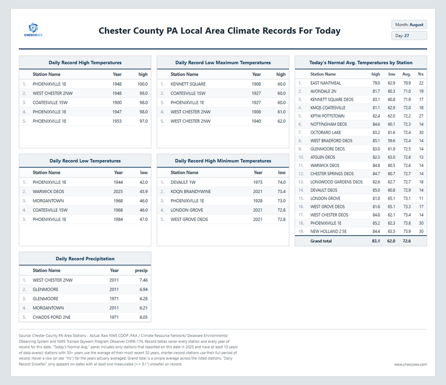
August 27 1992: A chilly night in Embarrass, where the temperature dips to 28 degrees. For Thursday, August 27, 2026 1854 - A tornado struck downtown Louisville around noon on Sunday, August 27th, 1854. It first touched down near 25th Street, southwest of downtown and lifted at the intersection of 5th and Main Streets. Although the tornado was only on the ground for a little over two miles, the twister claimed at least 25 lives. Many of those who perished were killed in the Third Presbyterian Church, where 55 people were gathered for Sunday church services. Straight-line winds that accompanied the tornado did significant damage to the Ohio River, where at least one boat sunk. 1893 - The first of three great hurricanes that year struck South Carolina drowning more than 1000 persons in a tidal surge at Charleston. (David Ludlum) 1964 - Hurricane Cleo battered Miami and the South Florida area. It was the first direct hit for Miami in fourteen years. Winds gusted to 135 mph, and the hurricane caused 125 million dollars damage. (David Ludlum) 1970 - Elko, NV, was deluged with 3.66 inches of rain in just one hour, establishing a state record. (The Weather Channel) 1987 - Washington D.C. soared to a record hot 100 degrees, while clouds and rain to the north kept temperature readings in the 50s in central and southeastern New York State. (The National Weather Summary) 1988 - Afternoon thunderstorms produced locally heavy rains in the southwestern U.S. Thunderstorms in eastern New Mexico produced wind gusts to 75 mph near the White Sands Missile Range, and produced three inches of rain in two hours near the town of Belen. (National Weather Summary) (Storm Data) 1989 - Afternoon and evening thunderstorms produced severe weather in southeastern Nebraska, eastern Kansas and Missouri. Thunderstorms produced baseball size hail south of Belleville KS, and tennis ball size hail south of Lincoln NE. Thunderstorms produced golf ball size hail and wind gusts to 70 mph at Saint Joseph MO. Thunderstorms in North Dakota deluged the town of Linton with six inches of rain in one hour. (The National Weather Summary) (Storm Data) 2013 - Numerous severe thunderstorms brought large hail along with wind gusts from 60 to 90 mph to parts of north central and northeast South Dakota. Numerous trees were downed along with many structures damaged. Eighty mph winds near Polo in Hand County snapped off two large cottonwood trees. Ninety mph winds snapped numerous trees off at their base along with destroying a garage and tipping several campers over onto their side at Cottonwood Lake near Redfield. Observances: 27 Thu National Just Because Day 27 Thu Crab Soup Day 27 Thu International Lottery Day 27 Thu Lyndon Baines Johnson Day 27 Thu National Petroleum Day 27 Thu National Pots De Creme Day 27 Thu The Duchess Who Wasn't Day
-
(002).thumb.png.6e3d9d46bca5fe41aab7a74871dd8af8.png)
Central PA Summer 2026 Discussion/Obs Thread
ChescoWx replied to Voyager's topic in Upstate New York/Pennsylvania
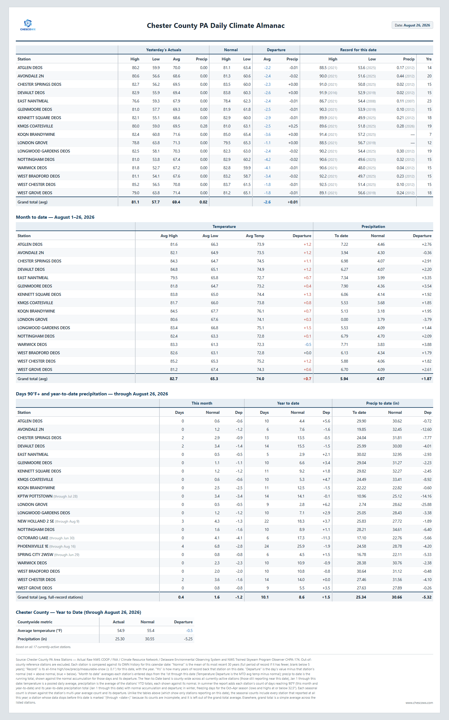
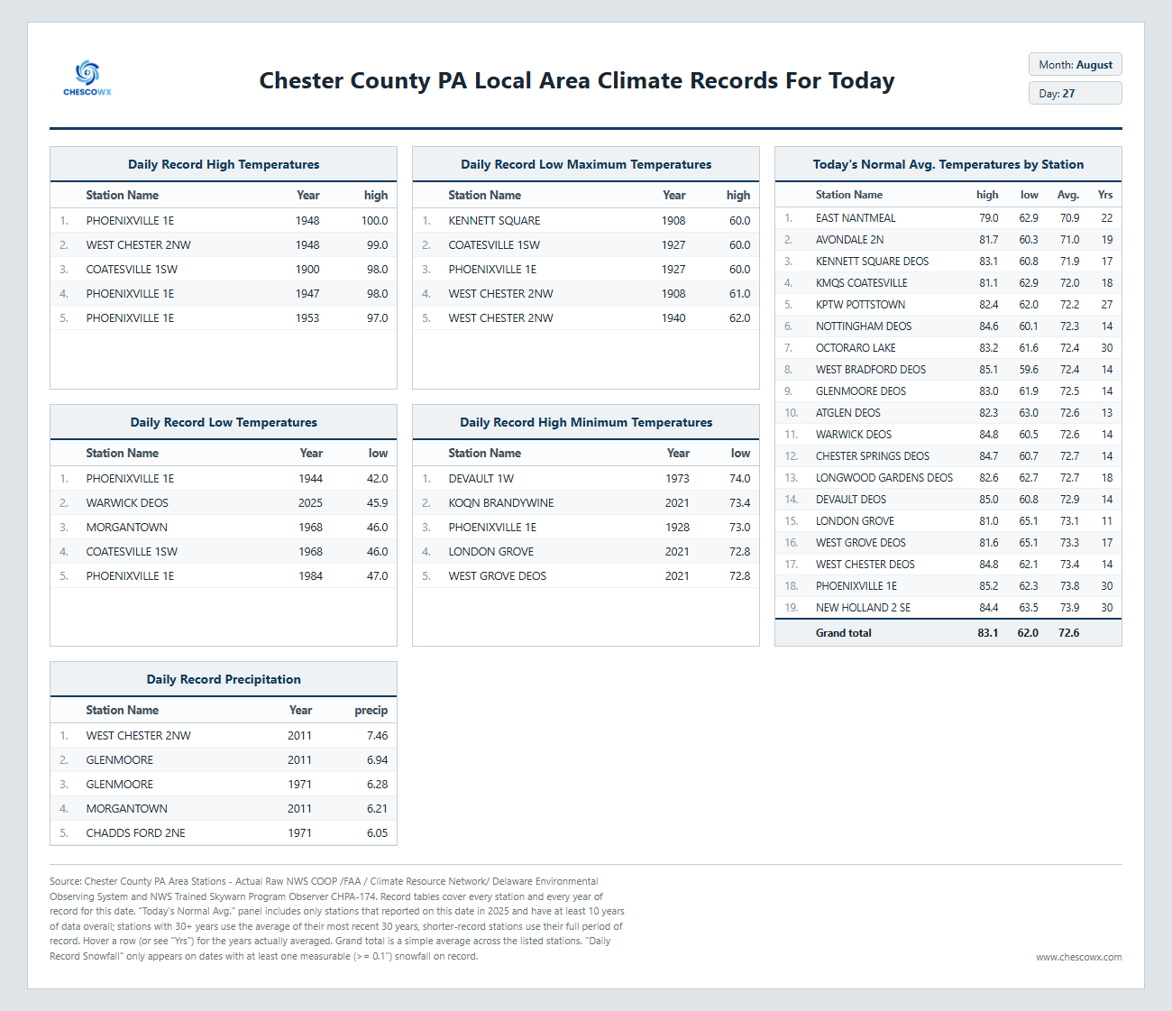
We had a brief shower this morning, but showers will become more widespread later this afternoon and into the night with the ChescoWx model predicting 0.44" of rain by midnight tonight. We start to clear up tomorrow and start a steady warming trend with our peak warm days looking to be next Monday and Tuesday. However, any 90+ days look unlikely especially for the ridge locations. I suspect we have already seen our last "heat wave" across the county.
-
E PA/NJ/DE Summer 2026 Obs/Discussion
ChescoWx replied to PhiEaglesfan712's topic in Philadelphia Region
We had a brief shower this morning, but showers will become more widespread later this afternoon and into the night with the ChescoWx model predicting 0.44" of rain by midnight tonight. We start to clear up tomorrow and start a steady warming trend with our peak warm days looking to be next Monday and Tuesday. However, any 90+ days look unlikely especially for the ridge locations. I suspect we have already seen our last "heat wave" across the county.
-
N NJ special
-
Nothing wrong with posting data....I just mentioned it looks just like 2023. Is that likely? Not IMO, but possible if Chuck is right about the N Pacific.
-
I think 15-16 is possible...97 and 82 is unlikely. That being said, I think in the absence of a N Pac vortex, assuming that is the case, the range of potential outcomes this winter would expand because we maybe less prone to an overwhelming Pac jet.
-

Augdewst 2026: Summer's Last Stand
Brewbeer replied to Prismshine Productions's topic in New England
most of the ones who post on here do maybe the twitter Mets do too, but everyone knows that twitter is a megaphone for hype and incorrect information; users of that platform are encouraged to independently verify currently 73/70, may need to turn on the house ACs if the sun comes out -
My position is in between both of you....I don't think it's merely a coincidence, as there are plenty of signs that El Nino has not yet coupled with the mid latitudes throughout the N Hem....however, Chuck seems more resigned to the fact that that won't change for winter than I am.
-
86 yesterday. Looks like summer for the foreseeable future. Yuck
-
Going off of my ambient station, 5.65" It has been matching my cocorahs gauge really well lately.
-
Whats your Aug total for the month so far?
-
 More details can be found at [url=https://www.medguideusa.com/guide/propecia/]MedGuideUSA[/url]. Good luck!
 -

2026-2027 Record-breaking El Nino
bluewave replied to Stormchaserchuck1's topic in Weather Forecasting and Discussion
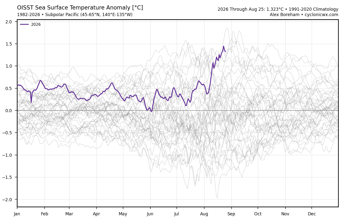
Yeah, rapid warming of the SSTs near Japan as the main ridge axis migrated west from the July position north of Hawaii.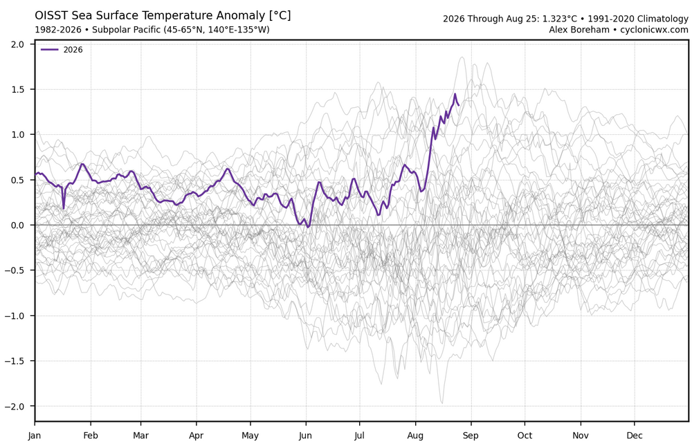
-
I got the same, .31"
-
Trust me it'll be cloudy all night, then clear skies afterward for two weeks.
-
-
Yeah it went nuts