All Activity
- Past hour
-
It's about time. Last December ended up normal to 1 degree below normal at most stations, after several ridiculously mild Decembers. If it were not for the big warmup after the white Christmas many of us enjoyed last year it would have been 2-3 below normal.
-

2025-2026 ENSO
brooklynwx99 replied to 40/70 Benchmark's topic in Weather Forecasting and Discussion
yeah, i'm pretty confident that we're going to see the NAO drop rather significantly as the Scandi / N ATL trough retrogrades... the WH MJO forcing is a strong precursor to that, as it helps wavebreaking occur in the N ATL -

December 2025 regional war/obs/disco thread
Ginx snewx replied to Torch Tiger's topic in New England
We shall see but again 53 is 90% of the time. Anyways coming soon. Thigh high to a horse
-

December 2025 regional war/obs/disco thread
Damage In Tolland replied to Torch Tiger's topic in New England
I don’t think you can use strict charts in a screamer . They’ll never catch onto the warmth fully until last minute . Factoring in Climo too much -
Nice! SE New England is hurting some though. Would love to see the same chart for the same date last year. We're off to a good start so far. Past performance is no indication of future results though.
-

December 2025 regional war/obs/disco thread
DavisStraight replied to Torch Tiger's topic in New England
EC-AIF has some serious cold around Christmas to the New Year. -
It is what it is at this point. We won’t be the only ones suffering. Best advice I’ve got is for everyone to take a deep breath at the keyboard, go outside, smell some Christmas trees, golf, fish, get some vitamin d. It’s been a cold 3 weeks and a break won’t be bad. I hope it’s not extended but what can any of us do about it? Jammin January and Fab Feb are just around the corner.
-

2025-2026 ENSO
40/70 Benchmark replied to 40/70 Benchmark's topic in Weather Forecasting and Discussion
Yea, I had found it...you're quick! Thanks. -
AUG was fortunate that no one got hurt by falling ice in January 2004. Plumbers had left a dead-end run of pipe on the 9th (top) floor of the Key Bank building. The temp dropped to -16 overnight, causing the pipe to rupture and pour water into and out of the building, wrecking office furnishings all the way to floor #1. Icicles 15 feet long and up to a foot diameter were draped on the northerly 1/4 of the building and ice had built up more than a foot thick on the sidewalk, also partially blocking Water Street. Think of 200-lb icicles falling from nearly 100 feet above. Cloud-free this morning. Low was -1.
-
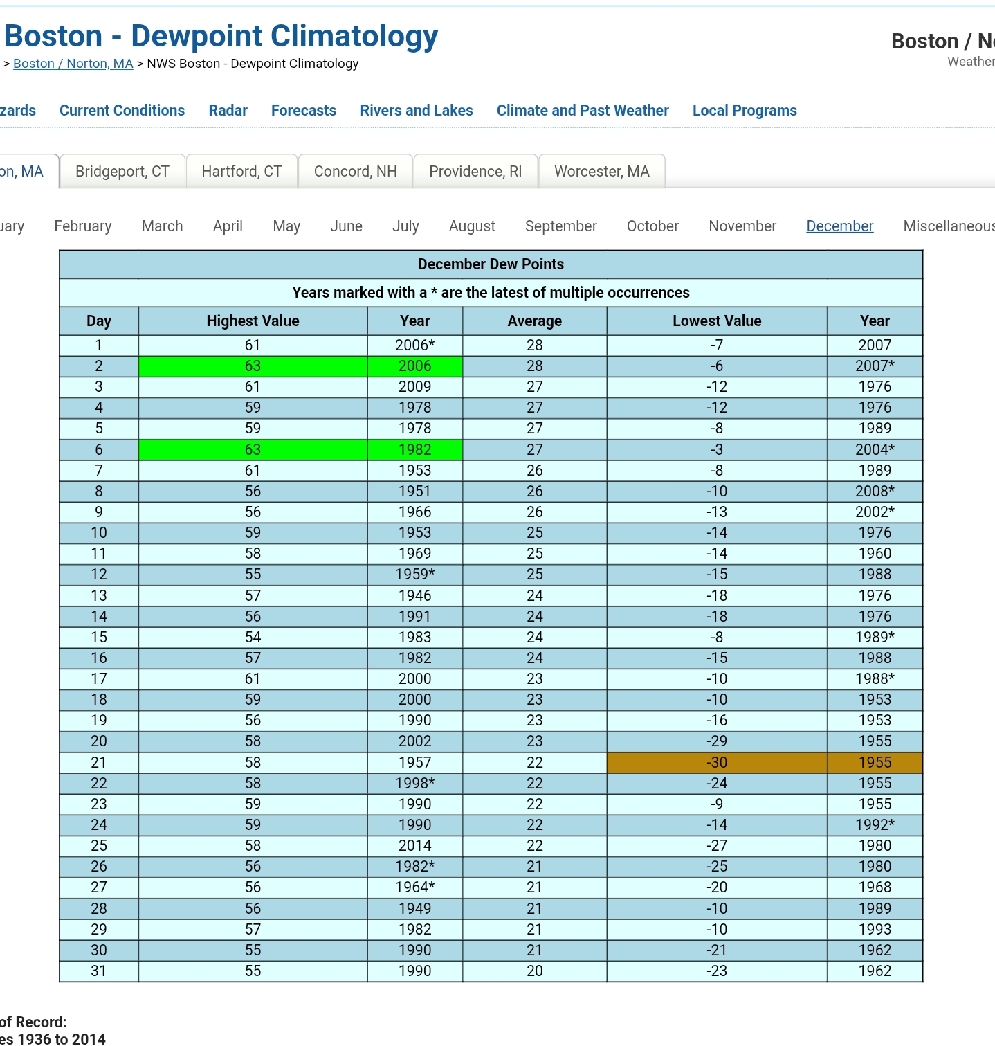
10th coldest for Madison too. 6.30 1919-12-01 1919-12-15 1 1 1 0 7.77 1972-12-01 1972-12-15 2 2 2 0 9.50 1958-12-01 1958-12-15 3 3 3 0 10.03 1917-12-01 1917-12-15 4 4 4 0 11.07 1976-12-01 1976-12-15 5 5 5 0 12.80 1898-12-01 1898-12-15 6 6 6 0 13.33 1893-12-01 1893-12-15 7 7 7 0 14.13 1876-12-01 1876-12-15 8 8 8 0 14.63 1942-12-01 1942-12-15 9 9 9 0 14.97 2025-12-01 2025-12-15 10 10 10 0
-
Through today, my Tempest is showing an average of 30.9F for December with a low of 10.5 and a high of 49. Pretty crazy. AI says NJ averaged 22.7F in Dec 1989 with 5 days below zero recorded in Ocean County - that’s honestly wild if accurate. Trying to imagine these first 16 days but averaging 8 degrees less is kind of breaking my brain.
-

Central PA Winter 25/26 Discussion and Obs
CarlislePaWx replied to MAG5035's topic in Upstate New York/Pennsylvania
Good morning from Carlisle, where it is white and very cold. Fresh snowfall (albeit very light) combined with no wind and clear skies provided ideal radiational cooling overnight which allowed my temperature to drop all the way down to +3.4 degrees F, the coldest of the season thus far. That inch of snow that fell yesterday afternoon was just enough to radiate down into the single digits. Having read through all the morning posts it looks like many of us dropped below 10 degrees overnight. And, my prediction from last night regarding THV came true. I said I thought York would drop to zero, and they did, hitting -1 F. -
December 2025 regional war/obs/disco thread
Ginx snewx replied to Torch Tiger's topic in New England
No Kev its Taunton east ..png.8fc80b627bbef871ab57337be011e72d.png)
.png.dedf3f5b2379601c2f4180a951d4c4fd.png)
-
December 2025 regional war/obs/disco thread
Ginx snewx replied to Torch Tiger's topic in New England
Like I said 53 seems to be my climo while Taunton East is higher. -
December 2025 regional war/obs/disco thread
Damage In Tolland replied to Torch Tiger's topic in New England
Ding ding ding . His area always is hottest in these . I’ll hit 56 here -
I think your area into interior SE Ma. Away from water.
-
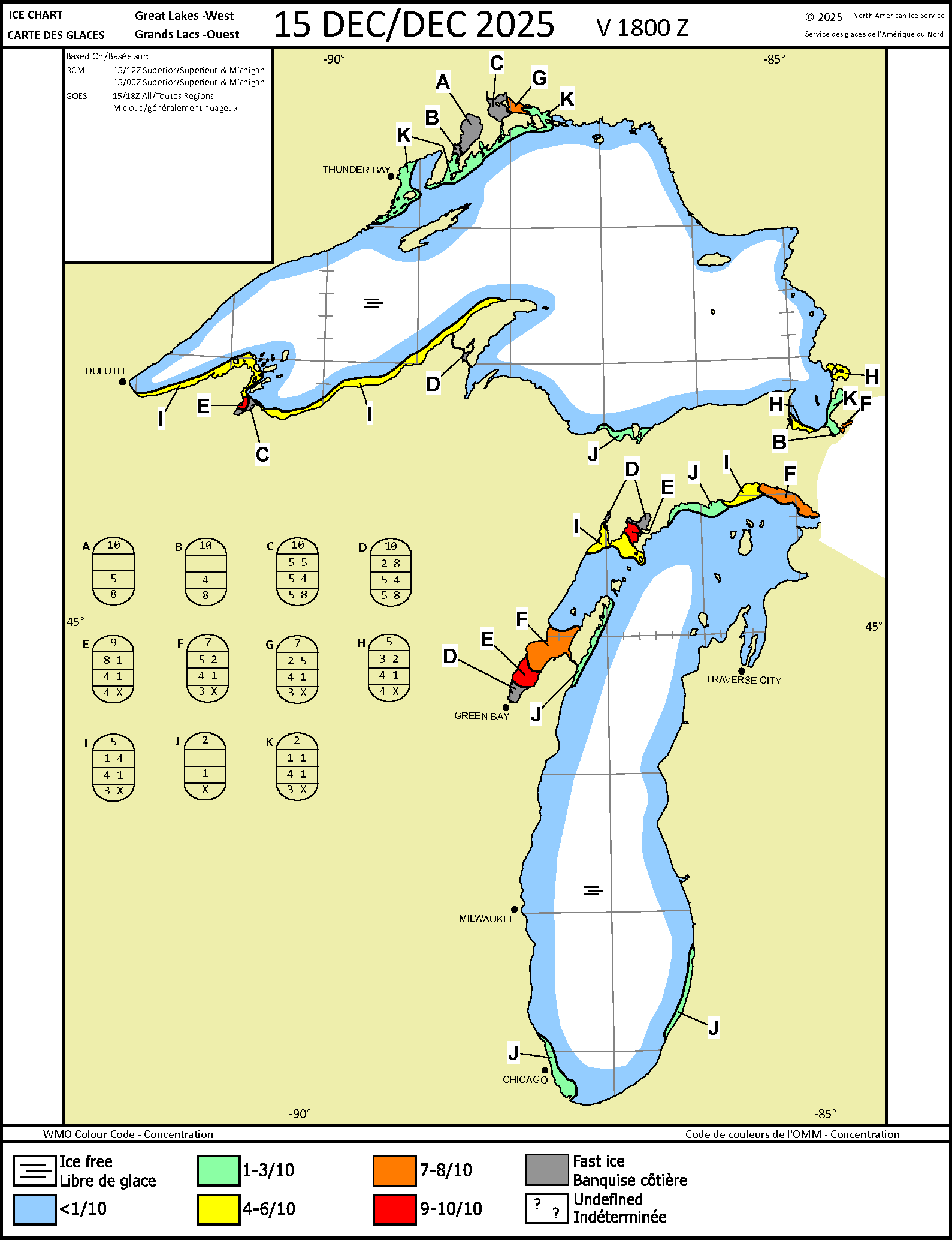
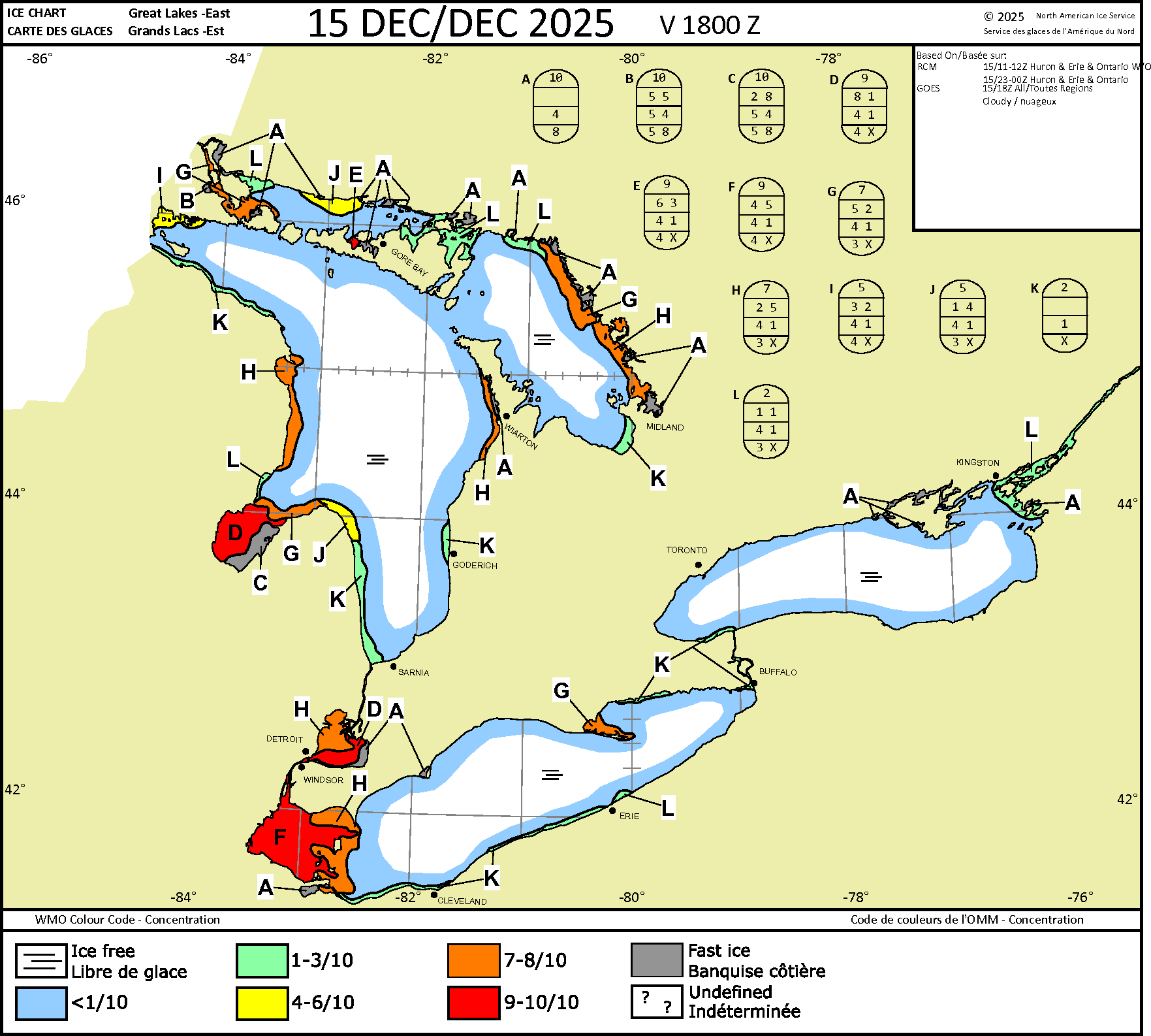
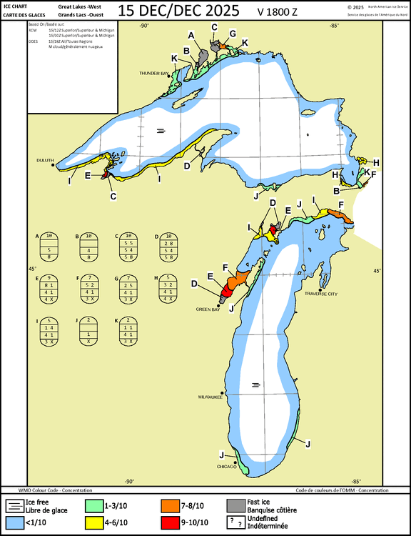
Ice is generally new/thin which would be typical this time of year. The warmer temps with gusty winds this week will knock it back pretty good as much of the detected ice is lower in concentrations across the Lakes. With such a cold start this year, the potential exists for a higher ice year with larger areas of thicker ice. Something we need to help the natural ecosystem. It actually helps to knock back some invasive species.

-
December 2025 regional war/obs/disco thread
Ginx snewx replied to Torch Tiger's topic in New England
Cape you yea -
Yeah spots will be close to 60
-
I do like that the NAO and AO are going down. I think around Christmas to New years will be our next threat in the east
-
Just broke over 32 degrees at 10:30 am. That is a bit over 56 hours below freezing, 42 hours under 20 and 11 hours below 10 degrees. Not a bad run before hitting the winter solstice.
-
Quick check on the ensembles today looks like a solid -pna pattern for at least the next two weeks with no credible snow threats for the MA. Perhaps some cold shots over the NE and MA. But we’re gonna have to wait this out a bit before the scand ridge retros into a GL block around new years.
-
December 2025 regional war/obs/disco thread
Damage In Tolland replied to Torch Tiger's topic in New England
This screamer is a beast -

December 2025 regional war/obs/disco thread
Go Kart Mozart replied to Torch Tiger's topic in New England
I have been noticing some interesting trends in the NHEM. The northern Caspian is already frozen, the Hokkaido ice bridge is forming, Saginaw bay is frozen, Hudson's Bay is waaaay ahead of last year (I believe full freeze up was January 17th), etc. How cold is the NHEM compared to recent trends? Is it a lot colder than "normal", or am I just being fooled by comparison to last year? -
December 2025 regional war/obs/disco thread
Ginx snewx replied to Torch Tiger's topic in New England