All Activity
- Past hour
-
Low of 61, high of 85. Dew points in the low 50's made for a pretty decent day.
-

E PA/NJ/DE Spring 2025 Obs/Discussion
LVLion77 replied to PhiEaglesfan712's topic in Philadelphia Region
49.9F and about an inch of rain for the event (regional precip total map a lot more uniform for this event than just about any other event this spring!)A lot less rain over the next 7 days but still lots of clouds unfortunately. We need a week of dry sunny warmth. . -
I was it was 100 here…but over a 75 dewpoint
-
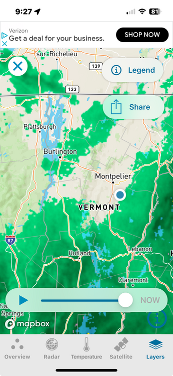
Just heavy precipitation rotating up through the eastern NE (esp SNE) zones. SE and E Mass look to be getting smoked. Impressive radar loop.
-
Abundance of sun here as well, managed a late afternoon high of 102 today off a low of ~72. Our warmest of the year thus far. Currently sitting at 100/21, dewpoints have been in the upper teens and low 20s all day. Looks downright miserable back in the coastal plain of NNE, I certainly don't miss these late May/June debacles.
-
Thunder in Fenway area
-
Holy crap just had a strike and boom so close/loud that it knocked stuff off our mantle lol
-
-
So long Cape Cod drought…
-
There's a great convergence of conveyor belts on this evening's regional radar. Its a cold season system evolution.
-
It's interesting that 2011, the year with by far the shortest time between first and last 90 degree days - 69 days - , is also the year that Newark had the 106 or maybe 108.
-
That one was a house shaker. Please let’s save some of the magic for the summer lol.
-
Yup, 51 today. Old record was 54 back from 1894. Thanks @uncle W for sharing that. 52 at Trenton broke record as well, was 55 set in 1909. Philly's 56 was good for 2nd place, it was 53 also in 1909.
-
Woods Hole, MA - Golf Club: 5.95", Falmouth, MA: 5.05
-
Several lightning strikes!! Scott FTW
-
This is really impressive LLJ taking its time lifting north Heaviest of day right now, hoping we hear some thunder Love the activity in here… if only this was January
-
Definitely glad I’m not in the prediction business with regard to the t storm I’m currently having
-
3”+ and counting
-
Almost looks like a mini meso over se mass..this is wild!
-
Probably would’ve been a broader precip shield since there’s a bigger difference between cold and warm ocean air-more overrunning, broader precip shield west. It might’ve been light rain/mix to heavy snow as the offshore low took over-we have a primary low that made it all the way to Buffalo. But it would’ve been another Juno/Nemo/Jan 2022 scenario.
-
Hrrr nailed this
-
Yeah thunder here too. Brutal out.
-
41° breezy and rainy. 0.50”
-
Thunder, wtf!
-
I have been in a similar dryslot almost all day. .20 for the day. In winter I would be bitter.