All Activity
- Past hour
-
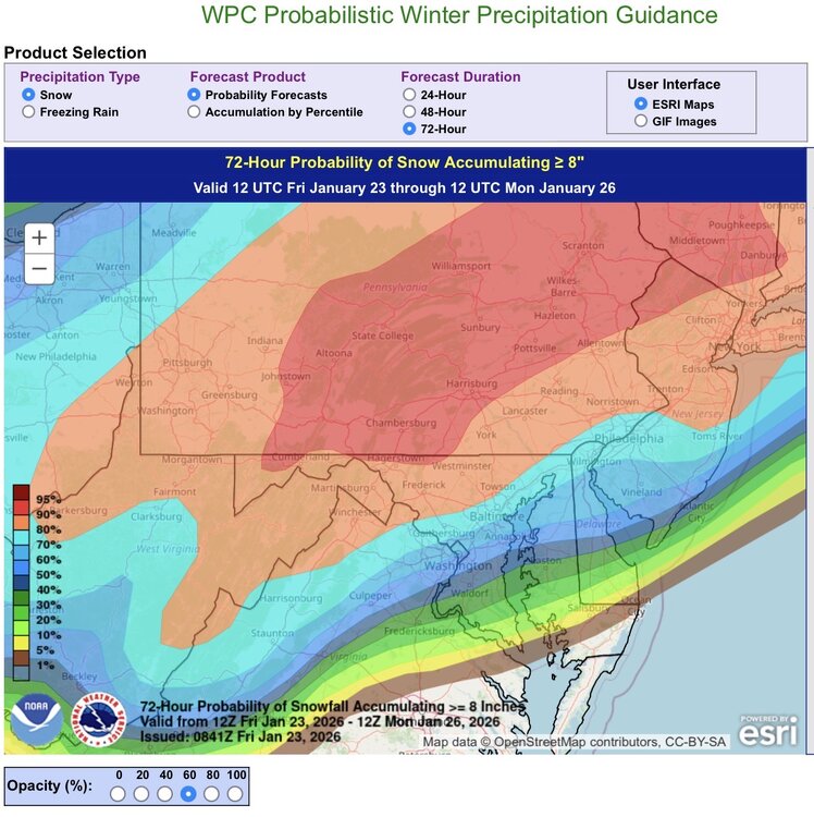
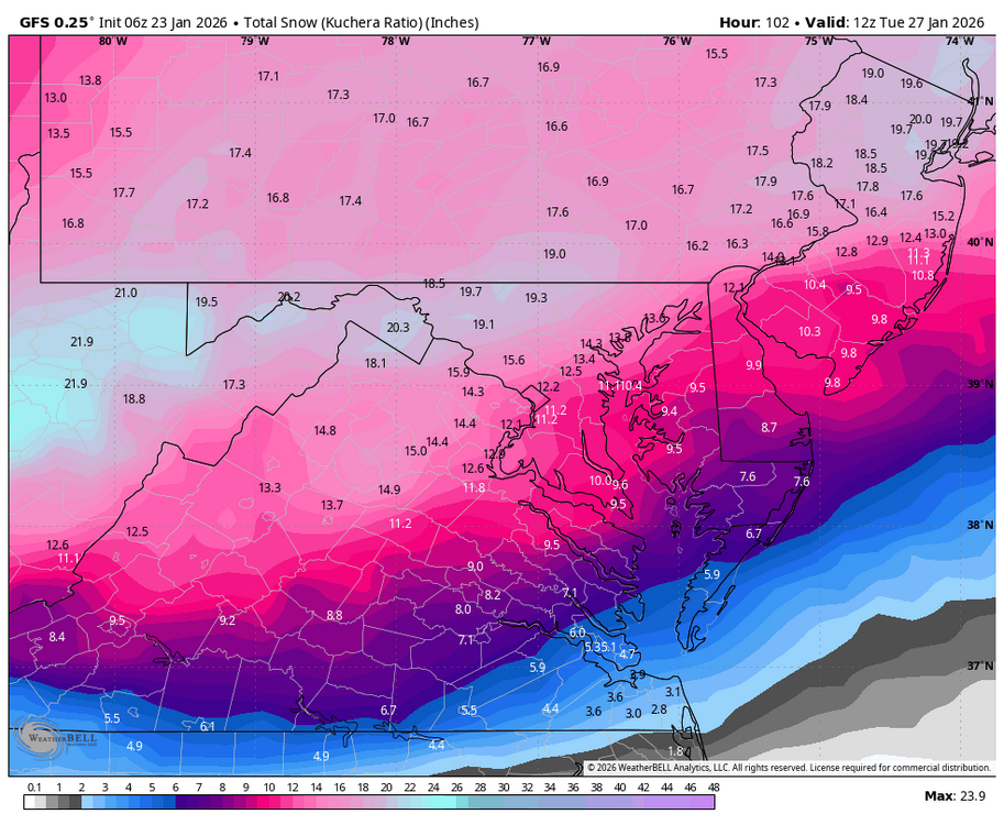
Updated percentage chance of hitting or exceeding 8” snowfall before flipping. For reference, DCA is at the 50% threshold.
-

“Cory’s in LA! Let’s MECS!” Jan. 24-26 Disco
moneypitmike replied to TheSnowman's topic in New England
Neither Jeff nor I even have a watch up. -
It's pretty clear that DC and east is going to be a massive sleet bomb. Such a bummer. Record cold and still can't snow lol.
-

MO/KS/AR/OK 2025-2026 Winter Discussion
rockchalk83 replied to stormdragonwx's topic in Central/Western States
Feels like Lucy pulled the football back on us in S KS overnight. We went from sharing in the big totals with you guys to the southeast, to having 6-8 inches. Hoping for a slight northward trend, but I think the models finally have a good grasp on the Arctic air and track of the second wave, so it probably won't happen. Bummer. -
Thank you for showing a Mid-Atlantic view.
-
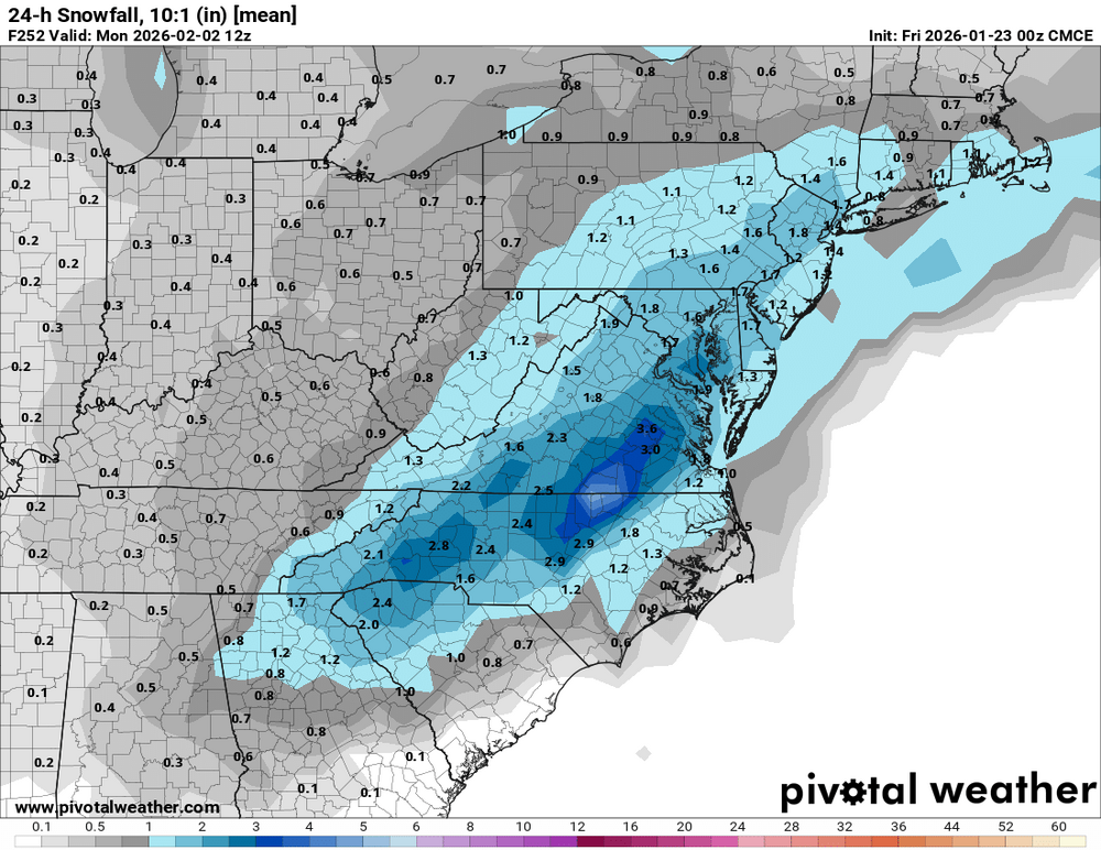
6z GFS has the storm for next weekend to. CMC ensembles for that potential as well
-
“Cory’s in LA! Let’s MECS!” Jan. 24-26 Disco
moneypitmike replied to TheSnowman's topic in New England
New Mattapoisett forecast calls for a change to sleet Sunday nigiht. Too bad we can move the mix line north but the qpf field isn't moving with it. Sunday Night Snow before 3am, then sleet. The snow could be heavy at times. Low around 21. East wind 10 to 14 mph, with gusts as high as 29 mph. Chance of precipitation is 100%. New snow and sleet accumulation of 4 to 8 inches possible. -

Possible Record Breaking Cold + Snow Sunday 1/25 - Tuesday 1/27
MANDA replied to TriPol's topic in New York City Metro
I gotta agree. Watching the NAM closely and not ignoring it. To blindly write it off as wrong is setting yourself up for disappointment. At least keep it in the back of your mind. If it is doing this on the 12Z runs tomorrow believe it. Still early enough for pause with it as of now. -
Woof .
-
6z GFS has a Thursday clipper. 2-3" for N VA/DC/Central MD with an inch or so surrounding that.
-
Still some red flags for me to go 18-24. Things anSWFE type deal after all with no closed 700 low. Just a thump of big time WAA. You really need a good CCB to help with that. The monday stuff is light as modeled even if you add a fluff factor. Not to mention it slots aloft as well.
-
00z geps had a big time signal for the Feb 1-3 period 6z AiGFS has a MECS 6z GFS elongated TPV, phasing Fun times ahead hopefully .
-
@TSSN+ All I’m saying is if you shave 2-3” off the GFS to account for it’s known issue not seeing mid level warmth these are all getting pretty close now. gfs rgem 0z euro


-

January 24-26: Miracle or Mirage Thread 2
SomeguyfromTakomaPark replied to mappy's topic in Mid Atlantic
NAM is only 0.4 qpf for dc pre flip, ive learned that when the NAM shows a mixing related disaster scenario, take it seriously. Not saying its gonna happen, hopefully its still figuring out the Synoptics, but don’t write it off. -
The 3k NAM drops over two inches of zr over Holston.
-
I've been happy with seeing greater than 0.5 of QPF on every model except the GFS up here, give me 6 inches of snow and I'll groom every trail out nice. This wasn't even supposed to be a Maine storm until a few days ago so this is all bonus!
-
The RGEM has extended it's snow line up into my area across that it had been showing across west and middle Tennessee. It has 4-5 inches over me and nearly 2 inches down to Knoxville now. Some of it falls after the lp passes.
-
January 24-26: Miracle or Mirage Thread 2
SomeguyfromTakomaPark replied to mappy's topic in Mid Atlantic
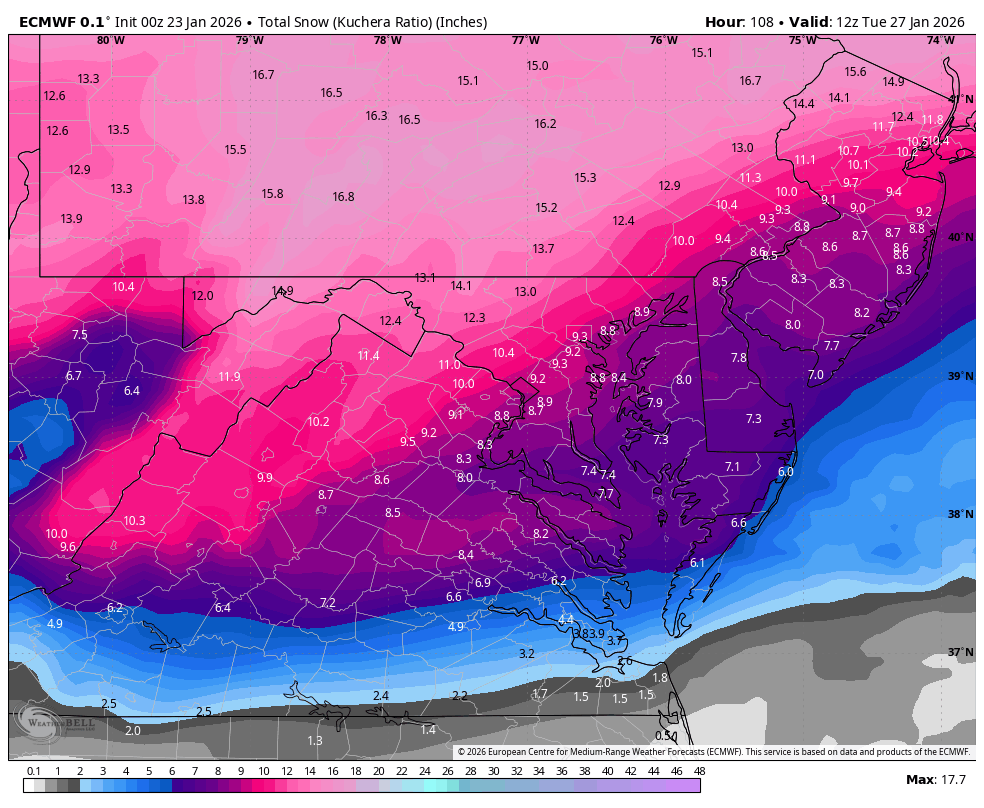
For dc Euro looks like about 0.8 qpf as snow, and then 0.6 qpf as sleet. 6-10 of snow and a thick layer of sleet, that’ll be a high impact event if it verifies. -
Ha Nam almost sleets to Kevin and me.
-
The RAP is an absolute crusher ice storm for all of Tennessee except one county in Southern Middle. Knoxville is bullseyed with 1.46 inches of qpf as zr.
-

Possible Record Breaking Cold + Snow Sunday 1/25 - Tuesday 1/27
MJO812 replied to TriPol's topic in New York City Metro
Nam jumps around alot. Thats why people ignore it. I do agree with you though. -
The RAP gives me around 4-5 inches, plus lots of sleet and zr. It has the 1.5 inches of snow line down to 40 in Knoxville.
-
Got it, thanks
-
Mount Holly going pretty aggressive here with the snow. Quite a range though so they cover their ass lol. 3-7 tomorrow night and 4-8 Sunday. I would have 2-5" here Sunday and insert sleet into the forecast.
-
“Cory’s in LA! Let’s MECS!” Jan. 24-26 Disco
moneypitmike replied to TheSnowman's topic in New England
It's a Norfolk/Plymouth oounty kind of winter on the 06 GFS.