TellicoWx
-
Posts
2,632 -
Joined
-
Last visited
Content Type
Profiles
Blogs
Forums
American Weather
Media Demo
Store
Gallery
Everything posted by TellicoWx
-
Basically, as more studies are being conducted (we understand very little of the exact why's/how's everything is linked), the number reading (+/-) doesn't mean exactly what it was thought to mean per se. A strong -QBO doesn't necessarily translate to cold East. The reading can be misleading..while we are currently at a +10..we are actually in a QBOE descending phase...Easterlies are beginning to work their way down thru the atmosphere. In last couple years there is strong evidence that depending how the whole column is moving (QBOE des/asc..QBOW asc/des), it can amplify or mute the effects of the MJO. Since we are currently in QBOE des...it should amply whatever phase the MJO is in. If we were in QBOW...even if the MJO was moving into the cold phases, it would not have as much effect as what we would think here. Everything is linked (solar flares/wind has an effect on QBO...which it's multi phases effects how the MJO reacts downstream...and so on)...Top-Down approach. One day we may be able to hopefully tie all the links together.
-
Agree with the microclimates..what makes being a weather enthusiast here that much more interesting. Something starting to notice is how this setup currently is hitting around Gatlinburg, is beginning to back to the SW..could help for mby if it can make the bend along the Blount/Monroe line
- 195 replies
-
- 1
-

-
- upslope
- may the flow be with you
- (and 1 more)
-
It's more NNW or due N trajectory
-
Same here..snowed most day but would melt off during any of the breaks..hill behind my house is about 150' or so higher...ground still white (little melting all day). Flakes now are small...figure DGZ is barely saturated enough.
- 195 replies
-
- 1
-
-
- upslope
- may the flow be with you
- (and 1 more)
-
Radar hasn't been showing anything here, so haven't looked outside since sundown. Light snow falling now, with dusting on elevated surfaces again.
-
Light dusting on the deck with small flakes falling...temp down to 33
- 195 replies
-
- 1
-
-
- upslope
- may the flow be with you
- (and 1 more)
-
Woke up to a surprise from MRX...added to the WWA (even tho I'm not quite sure of the logic behind the expansion). As far as winter weather headlines...added Monroe and the mountain zone of Polk County to the advisory for consistency with FFC as well as increased snow totals in those areas.
-
Fall/Winter Banter - Football, Basketball, Snowball?
TellicoWx replied to John1122's topic in Tennessee Valley
And this evening's GEFS lucky bingo snowmaggedon lottery number is........G12. And thanks for playing everyone.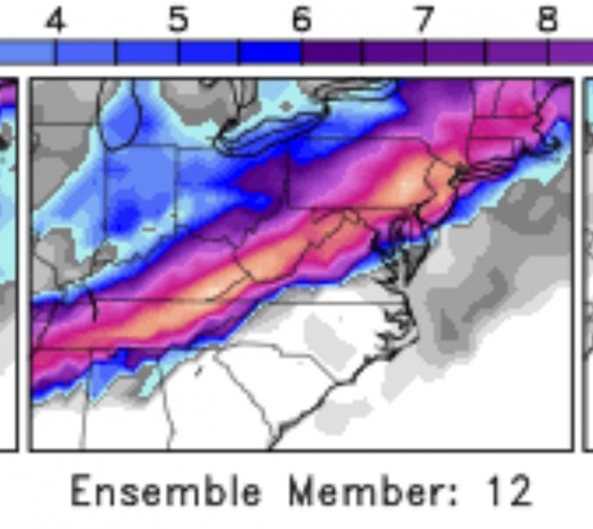
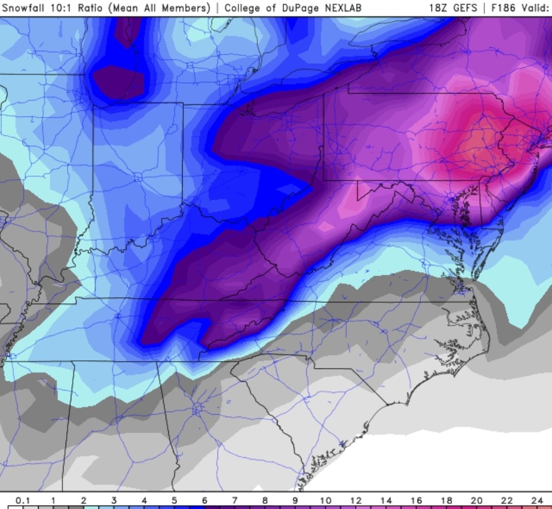
-
18z GEFS mean

-
Something interesting, my area (Tellico) usually does very poorly in NWSF events (Skyway is completely different story) due to the topography here (town almost sits in a bowl). MRX very rarely puts more than .5" on their maps for here due to this. So for them to go with 1"-2", it tells me they are currently expecting an unusually higher end NWSF event.
- 195 replies
-
- 2
-

-
-
- upslope
- may the flow be with you
- (and 1 more)
-
Considering it's coming from MRX, The CMC, ECMWF, and some ensemble members suggest surface low pressure development in the Gulf and progression to our south and east Saturday into Sunday. If this occurs, the potential exists for widespread, and potentially impactful, snowfall accumulation across the area.
-
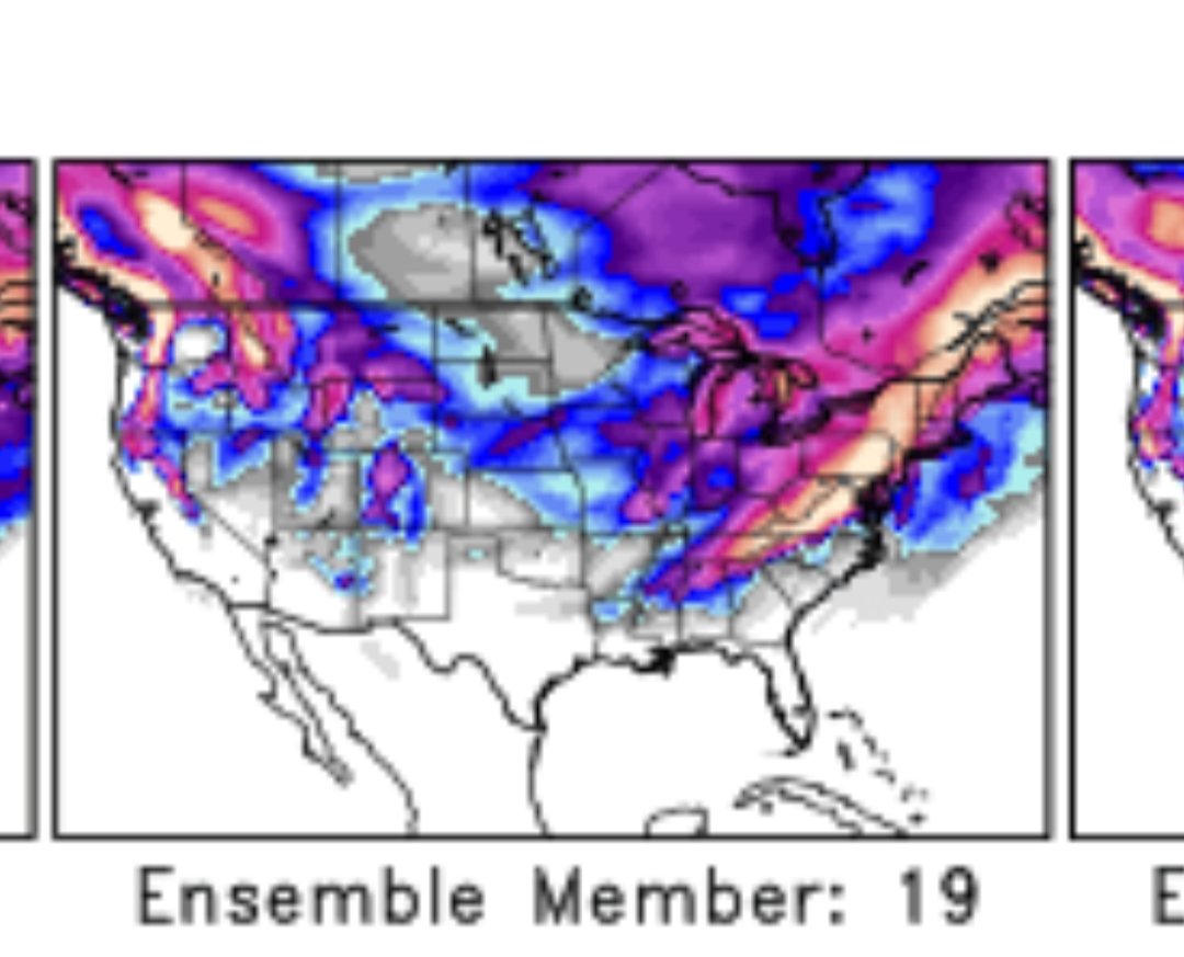
GEFS #19 may have skewed the mean slightly lol

-
January 27th-28th Boom or Bust Snow Event/Obs
TellicoWx replied to John1122's topic in Tennessee Valley
Pic of the Cherokee National Forest above Tellico this afternoon -
January 2021 Medium/Longterm Pattern Discussion.
TellicoWx replied to AMZ8990's topic in Tennessee Valley
0z GEFS doesn't agree with it..LA/C MS accum is from tonight..rest is the system during that time from..nice 2" mean back thru AL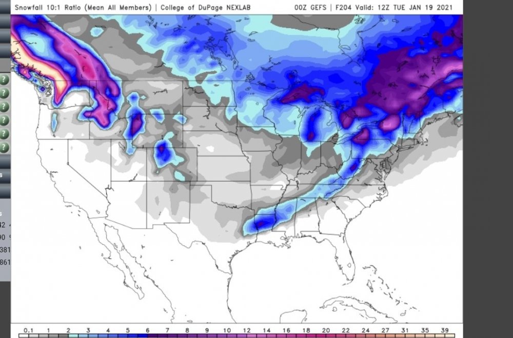
-
January 2021 Medium/Longterm Pattern Discussion.
TellicoWx replied to AMZ8990's topic in Tennessee Valley
0z GFS still had the energy, just shoved it to Cuba -
Jan 11-12 Mississippi Mauler: Will it or won't it?
TellicoWx replied to John1122's topic in Tennessee Valley
0z HRRR (vs current reports/radar)....NWS Jackson, Ms had to expand their WSW..WWA expanded across N. MS as well..said speed of system was quicker than anticipated. Alot of sleet reports across N. Al -
Jan 11-12 Mississippi Mauler: Will it or won't it?
TellicoWx replied to John1122's topic in Tennessee Valley
As we get closer...modeling is slowly ticking upwards for southern middle TN/plateau..may squeeze out an inch from it. 0z RGEM picking up on the increase in moisture -
January 2021 Medium/Longterm Pattern Discussion.
TellicoWx replied to AMZ8990's topic in Tennessee Valley
Considering it's 7 days out...fairly decent agreement at 500 with placement between GFS/CMC at 12/18z..Euro may be hanging the energy back in the SW..just something to watch. -
January 2021 Medium/Longterm Pattern Discussion.
TellicoWx replied to AMZ8990's topic in Tennessee Valley
12z CMC had something as well during that timeframe -
January 2021 Medium/Longterm Pattern Discussion.
TellicoWx replied to AMZ8990's topic in Tennessee Valley
Yeah..day 8/10 timeframe keeps popping up on various members last few runs. 18z GEFS had more variability among the members for that time roughly -
January 2021 Medium/Longterm Pattern Discussion.
TellicoWx replied to AMZ8990's topic in Tennessee Valley
Not a bad looking snow mean for the entire forum on the 12z GEFS
-
Hopefully you guys can squeeze a little more out tomorrow and maybe won't be too long for the next system
-
Skyway has turned into a skating rink here
-
January 7 - 8 ULL obs and nowcast
TellicoWx replied to Holston_River_Rambler's topic in Tennessee Valley
Better late than never lol...finally have wet flurries falling with a temp of 32.4...only about 20hrs behind schedule. -
Buddy sent me this from up on the Skyway...TN side roads are clear, NC side doesn't plow or brine theirs.