TellicoWx
-
Posts
2,632 -
Joined
-
Last visited
Content Type
Profiles
Blogs
Forums
American Weather
Media Demo
Store
Gallery
Everything posted by TellicoWx
-
TN valley heavy rain/flooding week of whenever
TellicoWx replied to janetjanet998's topic in Tennessee Valley
18z NAM doubled the totals across SE TN thru Fri evening. Went from 1.5-2 to 3-4 -
TN valley heavy rain/flooding week of whenever
TellicoWx replied to janetjanet998's topic in Tennessee Valley
Current conditions Ft Payne AL: Rain rate 1.13" hr..total 1.04" Nickel size hail reported and numerous lightning strikes...temp 39.2 Impressive dynamics. -
TN valley heavy rain/flooding week of whenever
TellicoWx replied to janetjanet998's topic in Tennessee Valley
TVA began flow reduction at the tributary dams here in East TN at noon today. -
TN valley heavy rain/flooding week of whenever
TellicoWx replied to janetjanet998's topic in Tennessee Valley
Just had a quick burst of moderate sleet here...cold not wanting to budge quickly. -
TN valley heavy rain/flooding week of whenever
TellicoWx replied to janetjanet998's topic in Tennessee Valley
Prob belongs in the other thread, but the 12z GEFS keeps the flow setup over the same region thru the run...ugly run for the flood threat areas. If we can't shut the Gulf down, this threat may extend well beyond current thinking. 12z GEFS (Complete run total):.thumb.png.0a47256493bc20b4195b5e8b496af2a4.png)
-
TN valley heavy rain/flooding week of whenever
TellicoWx replied to janetjanet998's topic in Tennessee Valley
12z GFS hangs the initial front across SE TN instead of pushing thru into N GA. Def something to watch. -
TN valley heavy rain/flooding week of whenever
TellicoWx replied to janetjanet998's topic in Tennessee Valley
Don't like how 00z suite has started..NAM quicker with onset, larger shield with WF, and less of a break. Rate of decent here is slowing over last couple hours and still near flood stage, need every hour we can get. As Carver mentioned earlier, will not take much of anything to top the banks again (let alone the 3+ the 3k is showing for this next event for near the state line. -
TN valley heavy rain/flooding week of whenever
TellicoWx replied to janetjanet998's topic in Tennessee Valley
Nearing 4 Trillion Gals forecast for TN. KY: 3.4 Tril, 6.47 Max, 4.84 Avg AL: 2.9 Tril, 6.57 Max, 3.21 Avg MS: 3.6 Tril, 6.56 Max, 4.27 Avg 7.3 Trillion just for OH/TN watershed. -
TN valley heavy rain/flooding week of whenever
TellicoWx replied to janetjanet998's topic in Tennessee Valley
WPC going 2-3" for midweek across SE TN...5-7" still thru weekend. -
TN valley heavy rain/flooding week of whenever
TellicoWx replied to janetjanet998's topic in Tennessee Valley
Each system has been like a stepping block. Definitely a rising "base". At 2000 cubic feet second we enter flood stage here. -
TN valley heavy rain/flooding week of whenever
TellicoWx replied to janetjanet998's topic in Tennessee Valley
18z GFS joins the other suites in the LR not shutting the Gulf down after this weekend. -
TN valley heavy rain/flooding week of whenever
TellicoWx replied to janetjanet998's topic in Tennessee Valley
It's lose/lose cause they had to open them here..i live right beside the Tellico River here in SE TN and we went into flood stage early this morning, if the tributary dams had not been pushing what they were, we would have had numerous water rescues. We are nearing 3" already, plus the modeled 6-7 thru this weekend and we will exceed the previous guidance from a few days ago. *bad part, as has been with everything modeled this winter on all models, is the bust factor (whether its pattern recognition, snowfall, or precip). Nearly every system has busted on the high side here this winter (except the snow one lol). -
TN valley heavy rain/flooding week of whenever
TellicoWx replied to janetjanet998's topic in Tennessee Valley
First one i posted was 240...i has all the systems -
TN valley heavy rain/flooding week of whenever
TellicoWx replied to janetjanet998's topic in Tennessee Valley
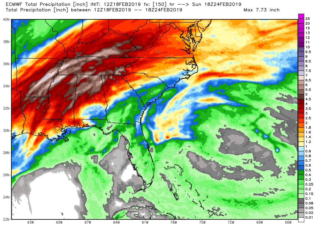
Totals thru the weekend system...Euro has 2 more systems next week. 1 Mon/Mon night (for southern areas), 2 Tues night/Wed region wide. Both have heavy rainfall.
-
TN valley heavy rain/flooding week of whenever
TellicoWx replied to janetjanet998's topic in Tennessee Valley
EPS looks to follow the GEFS/Euro Op in increasing totals...hate to be TVA looking at the data. Its a lose/lose situation nearly. -
TN valley heavy rain/flooding week of whenever
TellicoWx replied to janetjanet998's topic in Tennessee Valley
12z GEFS and 12z Euro Op (waiting on EPS)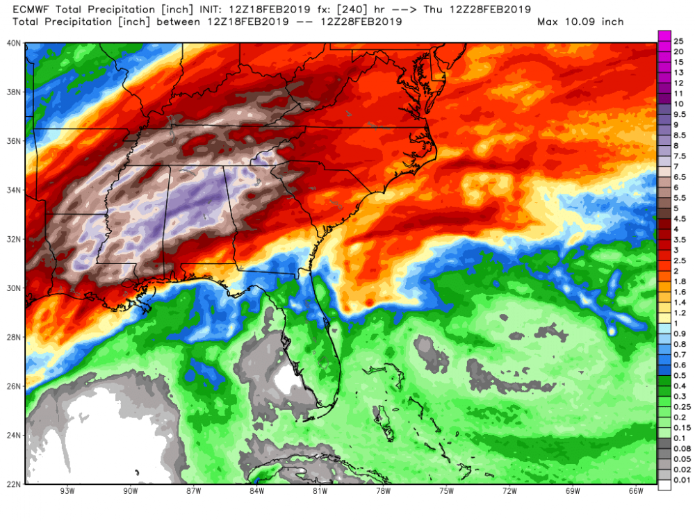
-
TN valley heavy rain/flooding week of whenever
TellicoWx replied to janetjanet998's topic in Tennessee Valley
As Janet has mentioned...todays 12z suite is ugly region wide (pretty much every watershed into the MS from KY to the gulf gets hammered. Was hoping the Euro would disagree with the GEFS, but not. Theme of this winter looks to roll on...rain...24-36 hr break...rinse/repeat. -
TN valley heavy rain/flooding week of whenever
TellicoWx replied to janetjanet998's topic in Tennessee Valley
Nickajack is running wide open...nearing 1 mil gallon a sec. -
TN valley heavy rain/flooding week of whenever
TellicoWx replied to janetjanet998's topic in Tennessee Valley
Only good news I see across modeling, is the timing..with the spacing of the systems it allows enough drying for TVA to keep drawing down and FFG to lessen a little, but river guidance still remains the same. -
TN valley heavy rain/flooding week of whenever
TellicoWx replied to janetjanet998's topic in Tennessee Valley
As has been the case most winter...ensemble and short range hi res is busting low here. GEFS was closer (1.1), EPS (1.0), and the 3k NAM (.8) vs reality (1.6). Not sure about other locations, but when you combine what has fallen with what is modeled on the ensembles, the 7-9 consistently shown at the start of the weekend looks on track. -
TN valley heavy rain/flooding week of whenever
TellicoWx replied to janetjanet998's topic in Tennessee Valley
River is beginning to near crest, about 1 1/2' below flood stage. Received 1.63" overnight, bringing total to 2.75". -
TN valley heavy rain/flooding week of whenever
TellicoWx replied to janetjanet998's topic in Tennessee Valley
00z increased totals some: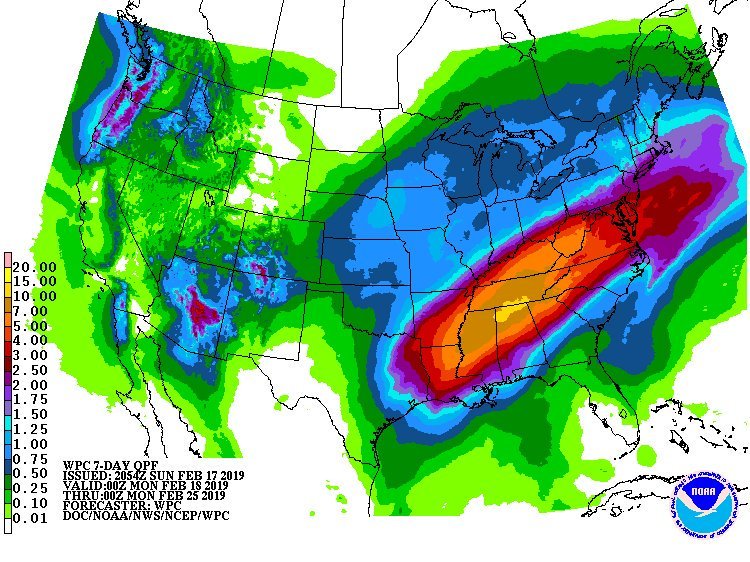
-
TN valley heavy rain/flooding week of whenever
TellicoWx replied to janetjanet998's topic in Tennessee Valley
Just had a message from Polk Co swift water team, deployed 3 hrs ago for two people submerged in a creek..unfortunately 1 fatality. -
TN valley heavy rain/flooding week of whenever
TellicoWx replied to janetjanet998's topic in Tennessee Valley
Picked up 0.11" so far today, and the gauge is already beginning to rise. There is zero water being soaked into the ground here, everything is going straight into the river. If we get anywhere close to 2003 level on the gauge, swift water teams will be deployed. -
TN valley heavy rain/flooding week of whenever
TellicoWx replied to janetjanet998's topic in Tennessee Valley
SWS just issued for tonight from MRX: Heavy rain forecast for today and tonight... Showers leading to heavy rain across eastern Tennessee and SW North Carolina for Sunday and Sunday night. Up to an inch and a half is possible especially across the southern Tennessee valley and the Smokey Mountains with possibly heavier local amounts. Due to the saturation of the ground from previous rain events, most of the rainfall is expected to result in excessive runoff with some areas of localized flooding possible. Stream flooding, roadway flooding, ponding of low level areas and potential mud slides are all possible. Lesser amounts are expected for the central valley region and more northern areas of the forecast area, including the Cumberland plateau. Due to saturated soils and rainfall from the last 24 hours, some local flooding could occur in the northern areas of the forecast area as well.

.png.0eef62775f250cadef6860bc23471570.png)