TellicoWx
-
Posts
2,632 -
Joined
-
Last visited
Content Type
Profiles
Blogs
Forums
American Weather
Media Demo
Store
Gallery
Everything posted by TellicoWx
-
December 2020 Medium/Long Term Pattern Discussion.
TellicoWx replied to John1122's topic in Tennessee Valley
00z Euro -
December 2020 Medium/Long Term Pattern Discussion.
TellicoWx replied to John1122's topic in Tennessee Valley
Yeah def a weird run...closes it off and drives it south while taking its time at 500..meanders across the forum -
December 2020 Medium/Long Term Pattern Discussion.
TellicoWx replied to John1122's topic in Tennessee Valley
00z GEFs looks better than 18z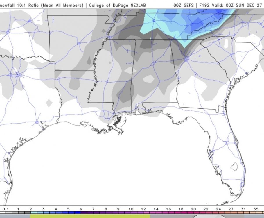
-
December 2020 Medium/Long Term Pattern Discussion.
TellicoWx replied to John1122's topic in Tennessee Valley
00z CMC -
December 2020 Medium/Long Term Pattern Discussion.
TellicoWx replied to John1122's topic in Tennessee Valley
12z vs 00z 500...both still produce areas of 6+ across the forum..GFS keeps honking about something lol -
December 2020 Medium/Long Term Pattern Discussion.
TellicoWx replied to John1122's topic in Tennessee Valley
And somehow still manages to produce for middle and east TN..will give it this, no matter how much it changes the 500 up.. it still produces (so far). Don't trust anything outside 60-72 hrs on any Op tho. -
December 2020 Medium/Long Term Pattern Discussion.
TellicoWx replied to John1122's topic in Tennessee Valley
Down side: 18z GEFs lost most of it's big producers Upside: It's the 18z GEFs lol 18z OP dug the energy a little more, slowing the front..but also had the energy more consolidated with the northern LP. -
December 2020 Medium/Long Term Pattern Discussion.
TellicoWx replied to John1122's topic in Tennessee Valley
Just glancing at this, but would bet the EPS is alot more like the GFS than the OP run. Euro OP consolidated the energy over the lakes (bombing the LP there)..EPS mean looks to track the parent LP into SE Canada similar to the GFS...need that separation. -
December 2020 Medium/Long Term Pattern Discussion.
TellicoWx replied to John1122's topic in Tennessee Valley
12z 500 vort: GFS/CMC/UKMET -
December 2020 Medium/Long Term Pattern Discussion.
TellicoWx replied to John1122's topic in Tennessee Valley
UKie at 144 is similar to the CMC vs GFS...GFS is more progressive with the front and secondary low at that point..UKie just further SW with the secondary. LP over the lake is pulling the front thru, all models showing their bias at this range. -
December 2020 Medium/Long Term Pattern Discussion.
TellicoWx replied to John1122's topic in Tennessee Valley
Hard to tell on pivotal cause it is on snow depth, but 12z GEFs looks better than 00z...Have they loaded for you Holstons? -
Fall/Winter Banter - Football, Basketball, Snowball?
TellicoWx replied to John1122's topic in Tennessee Valley
If the Apps can slow the front down giving the energy enough time to develop along the tail, things could get really interesting or if the trailing energy phases somewhat. Just glad to see modeling agree somewhat at this range with anything from a lee side low to a more miller A ish development...those range scenarios have proven to perform in the past. Give me a chance with a strong arctic front with energy along the tail any day of the week lol -
Been a cold raw day here...temps started dropping around 11 this morning
-
December 2020 Medium/Long Term Pattern Discussion.
TellicoWx replied to John1122's topic in Tennessee Valley
00z HRRR/3k NAM is kinda what I had playing out in my mind the other day. Global models usually tend to struggle when BL issues ars as close as it has been...meso models seem to be adjusting as we get closer..if rates are close to what's modeled, could def see a nice event west of the plateau...rooting for those guys. -
December 2020 Medium/Long Term Pattern Discussion.
TellicoWx replied to John1122's topic in Tennessee Valley
00z HRRR -
December 2020 Medium/Long Term Pattern Discussion.
TellicoWx replied to John1122's topic in Tennessee Valley
00z 3k NAM -
December 2020 Medium/Long Term Pattern Discussion.
TellicoWx replied to John1122's topic in Tennessee Valley
Yeah..made me laugh too...00z NAM made things interesting. -
December 2020 Medium/Long Term Pattern Discussion.
TellicoWx replied to John1122's topic in Tennessee Valley
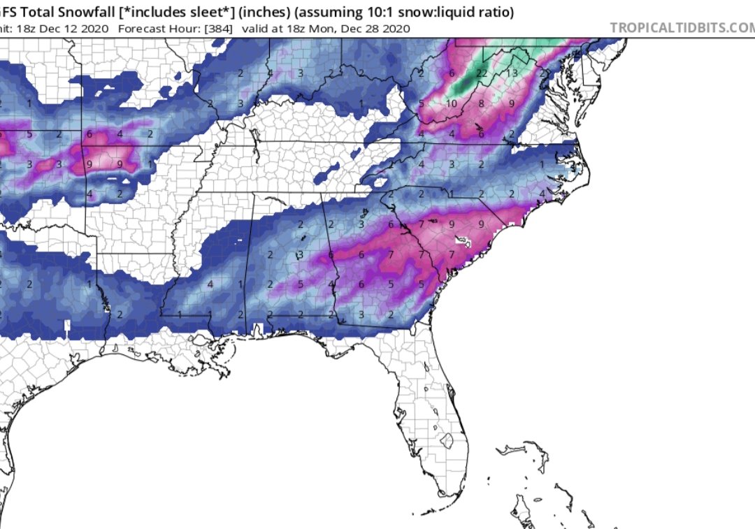
18z GFS run pretty much sums up last several years of winters for TN...entire state is a snowhole lol
-
December 2020 Medium/Long Term Pattern Discussion.
TellicoWx replied to John1122's topic in Tennessee Valley
Think we are starting to get somewhat of a solution...compromise between the progressive bias of the GFS and the overamping bias of the Euro (seems to have gotten worse since the upgrade, esp at mid range)...a weak southern slider, that has some boundary layer issues. Wouldn't be surprised to see the final solution be a 1-3" swath somewhere across the Mid south. -
December 2020 Medium/Long Term Pattern Discussion.
TellicoWx replied to John1122's topic in Tennessee Valley
GFS/Euro usually are at odds with each other but this is par for 2020 I guess lol...6z GFS=Noah's Ark across the Mid south/TN valley..0z Euro= Winter wonderland..polar opposites -
December 2020 Medium/Long Term Pattern Discussion.
TellicoWx replied to John1122's topic in Tennessee Valley
There was a study done on one of the old forums several years ago centered around Atlanta regarding what phases/amplitudes they scored sig winter weather in...surprisingly the COD produced more than any other amplitude. I believe you hit the nail on the head...to score we have to rely on a weak version of the SER (more so for the eastern side of the state. Over amplify in cold phases and the cold overbears the Gulf...reverse for the warm phases..torch city. -
Oak Moon Upslope/ Upper Low Storm Obs
TellicoWx replied to Holston_River_Rambler's topic in Tennessee Valley
Awesome, thanks for the report. Town ended up with 1.8"....decent little event.- 300 replies
-
- 3
-

-
- upslope snow
- upper level disturbance
- (and 3 more)
-
December 2020 Medium/Long Term Pattern Discussion.
TellicoWx replied to John1122's topic in Tennessee Valley
Think our middle TN folks would call it winter complete with that 00z GFS run for the end of the week lol.. -
Oak Moon Upslope/ Upper Low Storm Obs
TellicoWx replied to Holston_River_Rambler's topic in Tennessee Valley
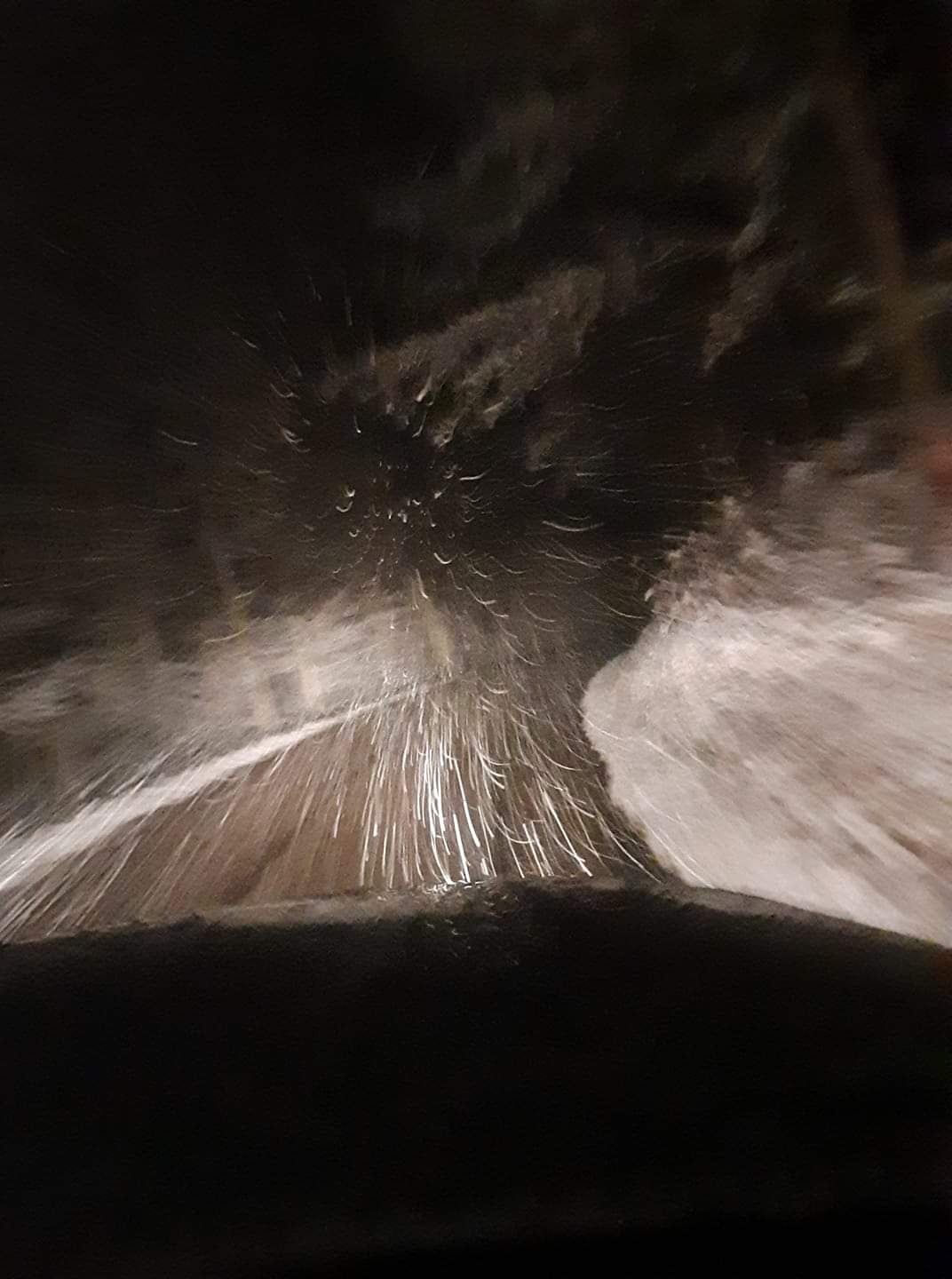
Still coming down at a nice pace.. definitely over performed here in town- 300 replies
-
- 6
-
-
- upslope snow
- upper level disturbance
- (and 3 more)
-
Oak Moon Upslope/ Upper Low Storm Obs
TellicoWx replied to Holston_River_Rambler's topic in Tennessee Valley
Still coming down at a good clip (about 2 miles from town)...Coker Creek area. Couple inches on the ground, roads slushy
- 300 replies
-
- 4
-
-
- upslope snow
- upper level disturbance
- (and 3 more)