

TellicoWx
-
Posts
2,632 -
Joined
-
Last visited
Content Type
Profiles
Blogs
Forums
American Weather
Media Demo
Store
Gallery
Everything posted by TellicoWx
-
Oak Moon Upslope/ Upper Low Storm Obs
TellicoWx replied to Holston_River_Rambler's topic in Tennessee Valley
Picked up .75" on the snow board in town..if you count what melted before sunset..looks like the RGEM did the best IMBY...think it is one of Holstons favorite winter models- 300 replies
-
- 2
-

-
- upslope snow
- upper level disturbance
- (and 3 more)
-
Oak Moon Upslope/ Upper Low Storm Obs
TellicoWx replied to Holston_River_Rambler's topic in Tennessee Valley
Pretty impressed for town (upslope only works out maybe 5% of the time). Good start to the season...maybe, just maybe it will be a good winter. We had what seemed like great teleconnections the last couple years that went exactly opposite. May as well try the opposite lol.- 300 replies
-
- 5
-
-
- upslope snow
- upper level disturbance
- (and 3 more)
-
Oak Moon Upslope/ Upper Low Storm Obs
TellicoWx replied to Holston_River_Rambler's topic in Tennessee Valley
Heavy dusting with everything turning white in downtown Tellico (830')...can only imagine what it looks like at Stratton Meadows (5400') on the Skyway- 300 replies
-
- 1
-
-
- upslope snow
- upper level disturbance
- (and 3 more)
-
Oak Moon Upslope/ Upper Low Storm Obs
TellicoWx replied to Holston_River_Rambler's topic in Tennessee Valley
Cherohala skyway about 2100' from a friend a couple hours ago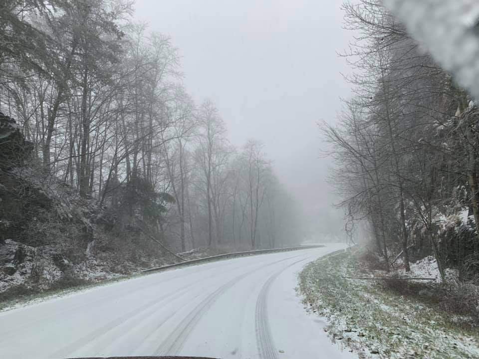
- 300 replies
-
- 5
-
-
- upslope snow
- upper level disturbance
- (and 3 more)
-
Oak Moon Upslope/ Upper Low Storm Obs
TellicoWx replied to Holston_River_Rambler's topic in Tennessee Valley
Starting to get some stickage on patios and grassy areas between Madisonville/Tellico..elev 1100'- 300 replies
-
- 4
-
-
- upslope snow
- upper level disturbance
- (and 3 more)
-
Oak Moon Upslope/ Upper Low Storm Obs
TellicoWx replied to Holston_River_Rambler's topic in Tennessee Valley
Yeah you can go from 870' in town to 5600' in a 17 mile span...I figure it will be hammering up there this evening- 300 replies
-
- 3
-
-
- upslope snow
- upper level disturbance
- (and 3 more)
-
Oak Moon Upslope/ Upper Low Storm Obs
TellicoWx replied to Holston_River_Rambler's topic in Tennessee Valley
Yeah if the valley is going to see a dusting or so, that is the area to watch..6z NAM was keying on that area but backed off on 12z- 300 replies
-
- 3
-
-
- upslope snow
- upper level disturbance
- (and 3 more)
-
Oak Moon Upslope/ Upper Low Storm Obs
TellicoWx replied to Holston_River_Rambler's topic in Tennessee Valley
Yeah, if you are a weather enthusiast, Tellico is an interesting place. You can go from 42 and rain to a blizzard and 25 in 15 mins down the road lol- 300 replies
-
- 1
-
-
- upslope snow
- upper level disturbance
- (and 3 more)
-
Oak Moon Upslope/ Upper Low Storm Obs
TellicoWx replied to Holston_River_Rambler's topic in Tennessee Valley
Mixing at the house 1900' and 35, it's switched over to Graupel in Madisonville (900'). From what I've heard so far, the state line on the Skyway changed over around 5am.- 300 replies
-
- 7
-
-
- upslope snow
- upper level disturbance
- (and 3 more)
-
Oak Moon Upslope/ Upper Low Storm Obs
TellicoWx replied to Holston_River_Rambler's topic in Tennessee Valley
6z 3k NAM seems to be picking up on maybe a little more energy rotating down the backside Holston mentioned earlier...now has the upslope producing in the Great Valley- 300 replies
-
- 2
-
-
- upslope snow
- upper level disturbance
- (and 3 more)
-
TN valley heavy rain/flooding week of whenever
TellicoWx replied to janetjanet998's topic in Tennessee Valley
MDT Flash Flood risk for Middle and East Tn: -
TN valley heavy rain/flooding week of whenever
TellicoWx replied to janetjanet998's topic in Tennessee Valley
The concern among alot of mets (including MRX.. the reason they switched from an Areal Flood to Flash Flood Watch) is going up. The first wave has overpefomed even compared to the 06z Euro (Chatt is approaching 1.5"-2" of rain so far). The main show is what's building over MS and the Arklatex. From MRX AFD: For Tonight, this first wave will move east allowing for a lull in the rainfall but another round of jet dynamics along a quasi- stationary over the region for late tonight through Tuesday morning. Models show a regeneration of rainfall coverage and intensity into the flash flood watch area. Favorably high PWs and warm rain process to produce a period of moderate to heavy rains with this next band. There is a good deal of differences on placement and strength of the low-level jet. The NAM is the most aggressive showing strong low-level moisture transport into this boundary while the GFS is weaker. Main question is exactly where this boundary becomes more quasi- stationary. Current thinking is that this boundary will remain across the central/southern areas into the central/southern Tennessee Mountains. Training of moderate to heavy rain is a major concern for these areas as PWs and thermodyanmic profile for favorable warm rain process will be unseasonably high. Given low FFG (saturated ground) and high stream flows, flash flood potential is a major concern through Tuesday morning. Model QPF ensembles depict around 3 inches at CHA and RHP, and 2 inches at TYS through Tuesday. Due to the potential of high rainfall rates and already saturated soils/high stream flows, decided to change the flood watch to a flash flood watch. Several river warnings have been issued as well. 6z Euro: -
TN valley heavy rain/flooding week of whenever
TellicoWx replied to janetjanet998's topic in Tennessee Valley
MRX has changed the Flood Watch to a Flash Flood Watch: The National Weather Service in Morristown has issued a * Flash Flood Watch for portions of southwest North Carolina, east Tennessee, and southwest Virginia, including the following areas, in southwest North Carolina, Cherokee and Clay. In east Tennessee, Anderson, Bledsoe, Blount Smoky Mountains, Bradley, Campbell, Claiborne, Cocke Smoky Mountains, East Polk, Grainger, Hamblen, Hamilton, Hancock, Hawkins, Jefferson, Knox, Loudon, Marion, McMinn, Meigs, Morgan, North Sevier, Northwest Blount, Northwest Cocke, Northwest Monroe, Rhea, Roane, Scott, Sequatchie, Sevier Smoky Mountains, Southeast Monroe, Union, and West Polk. In southwest Virginia, Lee. * Through Tuesday evening * Rainfall amounts of 2 to 3 inches with locally higher amounts expected. The heaviest rainfall will occur the rest of this afternoon and early evening across southeast Tennessee and southwest North Carolina with another round Tuesday morning area-wide. * This amount of rainfall could cause flooding. People in the watch area should be aware of the possibility of heavy rainfall. Avoid low lying areas...and be careful when approaching highway dips and underpasses. -
TN valley heavy rain/flooding week of whenever
TellicoWx replied to janetjanet998's topic in Tennessee Valley
New MCD out for southern valley: Discussion...Moisture is streaming in from the west-southwest within an atmospheric river moving into the region. Precipitable water values are currently 0.8-1.3". Inflow at 850 hPa is west-southwest at 30-50 knots per nearby VAD wind profiles, similar in direction and magnitude to the 850-400 hPa mean wind. MU CAPE remains under 100 J/kg for much of the area, though trends are upward across northern AL. Recent observations show hourly rain totals of 0.15-0.30", roughly 1/5 of the current precipitable water value, due to the lack of instability. With time, hourly rain totals are expected to rise to 0.5-1" as MU CAPE rises to 500+ J/kg across northeast AL and northern GA and convective elements become more common within the mostly stratiform rain areas. Mesoscale guidance generally advertises local amounts ~2", but 3" can't be ruled out during the next several hours. Two week precipitation anomalies are 150-300%+ of average, which has led to fairly saturated soils. Flash flooding is considered possible through 8 pm EDT. -
TN valley heavy rain/flooding week of whenever
TellicoWx replied to janetjanet998's topic in Tennessee Valley
High Risk has been extended into NW GA -
TN valley heavy rain/flooding week of whenever
TellicoWx replied to janetjanet998's topic in Tennessee Valley
Big question mark to me for today is around storm motion and orientation return flow. If the motion/return sets up more oriented ENE across N. AL then the results will be lowered (storms firing/training south of the area cutting off some of the flow from the gulf, plus a downslope component off the plateau)...HRRR/GFS. If it is orientated more NNE across N. AL, then the return up the southern valley will be greater and minimal downsloping (Euro Op/NAM). -
TN valley heavy rain/flooding week of whenever
TellicoWx replied to janetjanet998's topic in Tennessee Valley
Comparing the NAM, 3k, GFS, HRRR, Euro..with what has currently fallen here (.13). The Euro was the only one to have the rainfall into SE Monroe at this point. -
TN valley heavy rain/flooding week of whenever
TellicoWx replied to janetjanet998's topic in Tennessee Valley
High Risk out now to almost Chatt...WPC says there is still some uncertainty as to where to put the High Risk, could be moved north or south in further updates. For SE TN: Further downstream we have a Moderate risk across portions of northern GA into southeast TN and the far western Carolinas. Significant flooding is still possible here today/tonight. Slightly lower QPF and the expectation of weaker rates this far northeast, precludes the need for a High risk here. However, a Moderate Risk does cover these areas, which is still a significant and potentially life threatening risk level. -
SPC Day 4:
-
TN valley heavy rain/flooding week of whenever
TellicoWx replied to janetjanet998's topic in Tennessee Valley
Not surprising, a Flood Watch has been posted for south of I40. With area streams currently stressed (Tellico River is still running 200% above normal and is barely falling now) plus the snowpack up along the mountaintops that will melt and add to the totals, if any members (or family/friends) live in a flood prone area/ or potential to be cutoff by flooding across southeast TN...would be putting together some form of evacuation plan now. Add in SPC now has a 30% Day 4 severe near Chatt, looks like its gonna be a rough weather week. -
TN valley heavy rain/flooding week of whenever
TellicoWx replied to janetjanet998's topic in Tennessee Valley
13500 cubic feet per sec...haven't seen the Tellico River this high since it collapsed the Cherohala Skyway in 1993. -
TN valley heavy rain/flooding week of whenever
TellicoWx replied to janetjanet998's topic in Tennessee Valley
01z HRRR would be a big problem here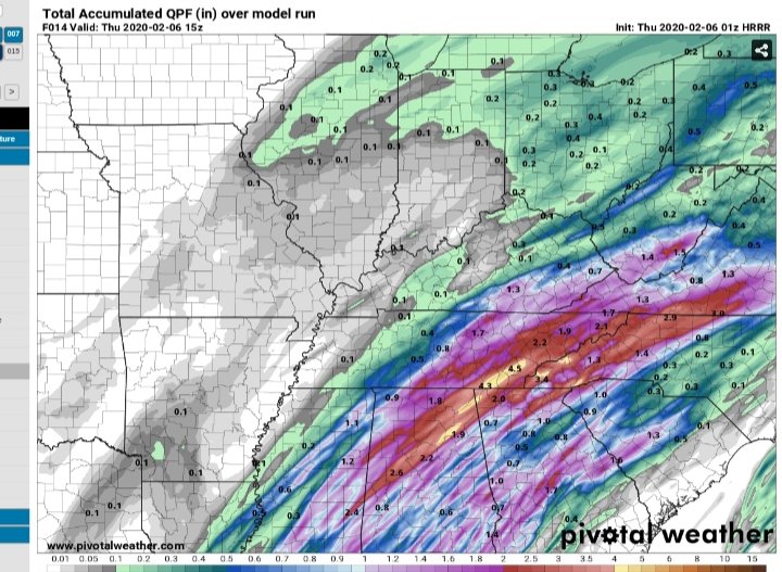
-
TN valley heavy rain/flooding week of whenever
TellicoWx replied to janetjanet998's topic in Tennessee Valley
Yeah, not liking the 0z runs so far or the 01z HRRR here for SE TN. Models upped the totals. Alot of people this afternoon were talking about how the worse was over cause of the break...afraid alot are going to be caught off gaurd. -
TN valley heavy rain/flooding week of whenever
TellicoWx replied to janetjanet998's topic in Tennessee Valley
Big time flooding here in Monroe Co..houses starting to flood, roads impassable, and starting to evacuate some people in the county. -
The common analog on SARS the last several runs is 4/18/69. That system produced an F4 in Greenville, AL killing 2. A total of 13 tornadoes formed, mostly in the F0-F2 range. A 218 mi path was also recorded in southern GA and rated F2. Storm caused 50 injuries, besides the 2 deaths in the F4.

