TellicoWx
-
Posts
2,632 -
Joined
-
Last visited
Content Type
Profiles
Blogs
Forums
American Weather
Media Demo
Store
Gallery
Everything posted by TellicoWx
-
0z HRRR picking up on the cold overnight more vs 18z in the valley
-
I've seen it happen here in Monroe..Sweetwater to Mt Vernon area pickup 3"-4"....Tellico nada but rain. If the downsloping winds are strong enough, it will scour the foothills that bank right up against the Smokies/CNF quickly, while 5-10 miles away locks in the cold way longer.
-
15z RAP with another paste job
-
0z NAM starting to step toward the other models...brings ice into the eastern valley
-
Think the GFS is trying to pickup all the valley locations, but doesn't have a low enough resolution. It's trying to show the cold becoming entrenched but the algorithm is spitting out snow...that's an ice look.
-
18z GFS...keep working that mojo Carvers lol
-
Up to 1365 w/o power now
-
Well that was interesting, temps went from 42 to 59 back to 39...in a span of 15-20 mins. Had wind gust close to 60mph, at the time..almost 1000 residences without power now.
-
Crazy to think as most of the state deals with freezing weather, I will be close to 60 up here in the mountains tomorrow. Everyone from the plateau west stay safe/warm.
-
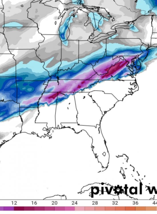
If the cold can penetrate enough to give BHam 6" and New Orleans a major ice storm like the RAP showed..the valley would score as well. Has the bulk of the precip lagging behind the low
-
I could easily see somewhere between Jackson and Nashville topping 12"..best ratios and qpf.
-
West and Middle TN are about as locked in as you can get (barring a giant shift SE which would hurt western areas), the big question mark is the plateau/valley
-
Based off the depth of the cold banked against the plateau on soundings.. the Eastern valley is literally only a 100' or so from being a sig. ice event vs mainly cold rain. GFS/NAM doesn't pull enough thicker cold to clear the plateau until the system has passed (due to track)..Euro would be very similar to the RGEM/CMC except it has multiple lows vs one primary (@850), which mess it up for one frame. RGEM would be more ice than depicted, once that cold tops the plateau it will rush into the valley.
-
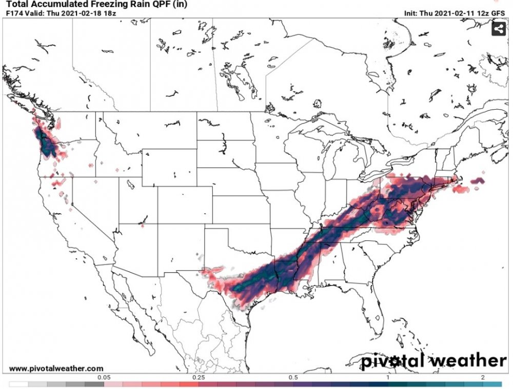
FRAM is the Freezing Rain Accumulation Model..similar to how Kuchera is used for snowfall...simulates the ice to liquid ratio for freezing rain events
-
UKie on pivotal combines freezing rain/sleet with the snow accum
-
Ugly 12z...systems almost train over the same areas
-
GFS is just one system after the next for middle/west TN
-
The higher the 850's are, the more heat that is trapped in the water molecules that must be released during the ice formation
-
Actually it's not...here's the process that happens, it's the reverse of what happens during evaporative cooling. Evaporative cooling is going from a solid (snow) to liquid (rain) as it falls thru the column..to complete the process it needs to absorb the heat from the surrounding air. Freezing rain just reverses that (liquid to solid). When water (in any of the three phrases) moves from a lower to a higher ordered state, the air surrounding the H20 will have energy added to it. This is called a release of latent heat (e.g. when heat is subtracted from liquid water, the individual water molecules will slow down. They eventually slow down to the point at which the hydrogen bonds do not allow the liquid to rotate anymore. Ice now develops. The energy the water molecules once had to rotate has been given up to the surrounding air). The three processes that add heat to the surrounding air are condensation, freezing and deposition (gas to solid).
-
Yeah it dropped the entire line about a county south
-
If the NAM 3k is off by a hair..Memphis is in trouble..2" amounts showing up just north of the metro
-
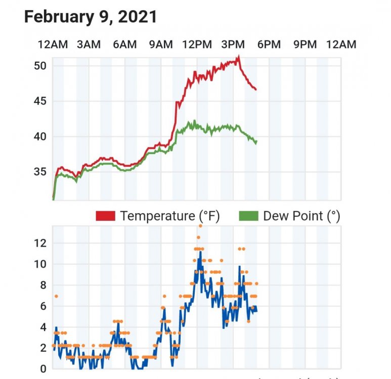
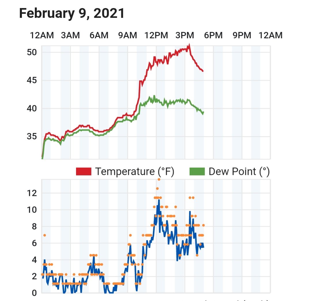
Example of how the rain droplets transports the warmer 850s to the surface..but it's only going to add a degree or so. Big Rock, TN as the moisture/drizzle moves in (temp rose from 29.8 to 30.4, even tho the winds remained from the north...elev 694'
-
Latency made add a degree at best...only way I see that helping is if you were borderline 30-31°
-
Agree 100%
-
If I lived within 50-75 miles of where the front (ice) was progged, I wouldn't let my guard down. Front is moving thru Nashville..Goodlettsville has been steadily falling just to the NW.