

TellicoWx
-
Posts
2,632 -
Joined
-
Last visited
Content Type
Profiles
Blogs
Forums
American Weather
Media Demo
Store
Gallery
Everything posted by TellicoWx
-
0z GFS held serve
-
That's insane rates along the NC/VA border on the 0z GFS...pegs pivotal out.
-
0z RGEM
-
This image from the 0z RGEM speaks volumes...back that center up 50 miles and those type of returns, would be crazy. (0z RGEM looks good regardless)
-
@John1122and @dwagner88both make valid points. Honestly, there's accurate enough algo to determine what will actually stick. If I was forced to make a call (barring a meltdown with the rest of the 0z suite and 6z), I would say 1"-3" for the valley, 2"-4" for the rim of the foothills, and name your number for the mountains. But thats why I don't get paid to make calls too lol.
-
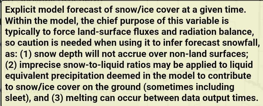
Straight from Pivotals site..each site uses a slightly different algorithm for depth
-
Maybe John knows, but when was last time entire state had runs like the 0z is spitting out?
-
Nam matched the HRRR
-
Am in no way saying this is the same, but March 10, 1993 the high temp at TYS was 71° (everyone knows what followed)....learned the hard way what time of day/ rates can do.
-
Agree, once go below 34 is where I start watching the roadways. Seen plenty times where shaded areas especially begin accumulating. Heavy rates/night (lack of solar radiation) = slush, which just speeds up the process of the asphalt cooling.
-
Think if 0z holds course....mtns will get a WSW. Only way I see them pulling one for the valley would be for the Euro to line up completely with the rest of modeling. They prob. will differ to the morning shift, and wait for the full 6z suite for the valley.
-
Any area that gets close to 32, combined with those rates and night time...will begin accumulating on any road surface
-
Was just saying the same thing...hrrr is deepening at the perfect time, slowing the flow...if it plays out this way, the wind generated will be another big story combined with the heavy wet snow.
-
Hrrr was a little slower with changeover in the valley, but is deepening further to the west (NE GA/NW SC) border (better trajectory for the heavy snow for the valley.
-
Biggest runs we have seen in awhile at 0z and 6z. Hate to be MRX in this situation.
-
Believe the RGEM would look very similar but it's downsloping the moisture on this side of the Smokies for the valley. Heavy rates on the NC side.
-
Still at work...wth did the GFS smoke lol
-
Biggl winner on 3k.....Birmingham, AL lol
-
18z NAM looks like it tried to Amp even more and derailed itself lol...see if 3k follows suite
-
18z HRRR
-
Definitely remember one...but won't speak its name
-
Euro definitely caved to the GFS..
-
3k was alot better for western and Middle areas
-
Yep looks correct...snow hole right over @nrgjeffhouse lol jk


