TellicoWx
-
Posts
2,632 -
Joined
-
Last visited
Content Type
Profiles
Blogs
Forums
American Weather
Media Demo
Store
Gallery
Everything posted by TellicoWx
-
12z NAM already looks better @33
-
Not even sure the 0z NAM is going to squeeze out a flurry lol
-
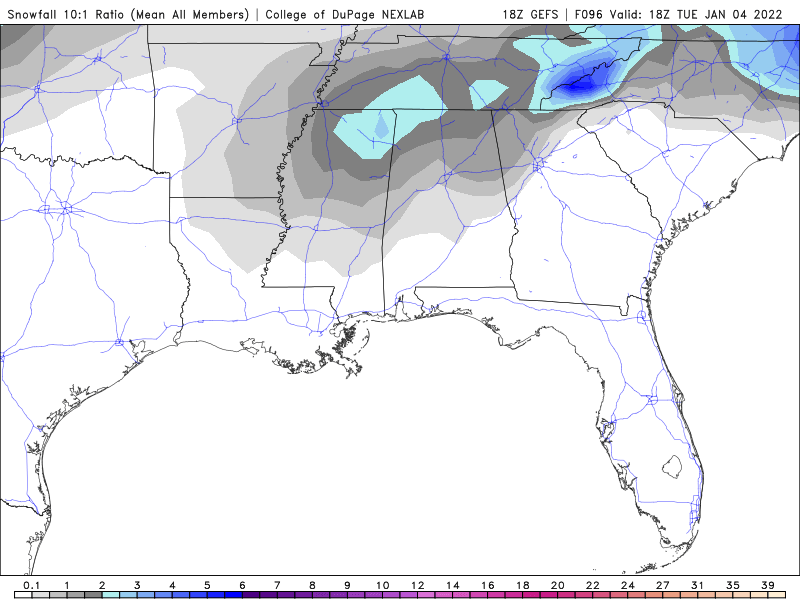
18z GEFS has some 2" means back into MS/AL
-
18z GFS looks aloy like the RGEM
-
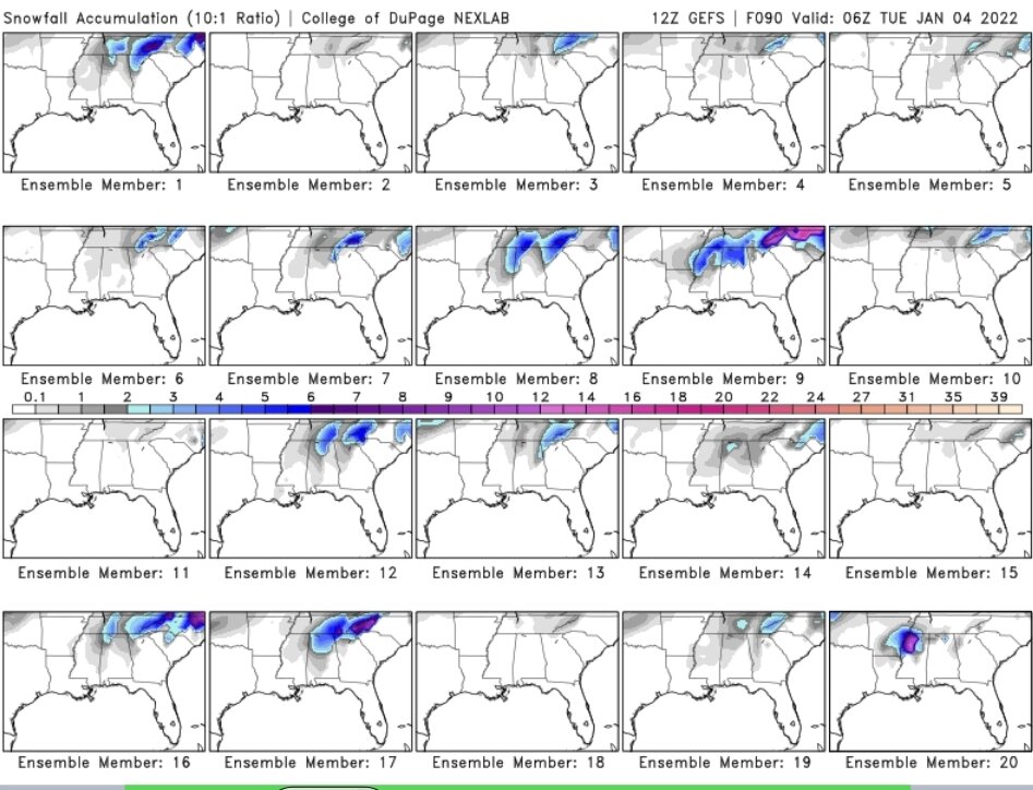
Glancing at the 12z GEFS...still quite a bit of spread between nothing and a decent little event
-
18z NAM
-
18z NAM says fine then...I will join the party lol
-
Lol, been waiting on the Pac to reconfigure. I would be surprised if someone isn't dealing with a major event as we head into/thru Jan (not necessarily E. TN) in the mid South. Dec setup has really built the fuel up along the gulf, so all its going to take is a potent front with a trailing vort near the gulf and the potential is there for a big event.
-
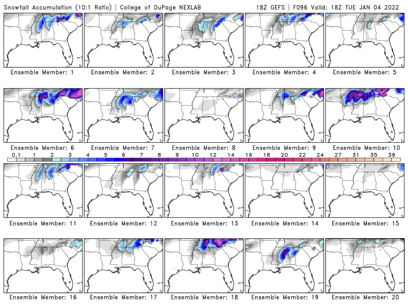
Really interested to see the 0z runs tonight...while the GFS OP has been on/off again for the weekend..its had little GEFS support. 18z GEFS starting to support the snowier OP run this time. Roughly 8/20 members now have a decent system.
-
Fall/Winter Banter - Football, Basketball, Snowball?
TellicoWx replied to John1122's topic in Tennessee Valley
1st weenie map of 21/22 lol... -
Listening to NYFD Staten dispatch...partial building collapse with people trapped in the basement...calling for divers to be dispatched to reach the basement.
-
Folks in SE TN shouldn't sleep on this system..while nowhere near as robust as AL/MS, there is a potential for a lower end tornado across that area..excellent write up from MRX. Confidence has increased a bit for severe convection over the S half of the CWA Wed night, but uncertainty still exists regarding both how far N and how quickly the warm front will advance into our region which determines where the surface instability gradient will be. The mid/upper closed low and surface low complex will lift toward S IL Wed night with the surface low deepening to about 995 mb. As this occurs, the upper jet rounding the E side of the system will strengthen to 100-110 kts and shift over the TN Valley and S Appalachians causing the LLJ to strengthen to 50-70 kts. This will support strong WAA and moisture transport, as well as strong frontogentic forcing along and north of a northward advancing warm front. The last few runs of the NAM are outliers in keeping the warm front S of our region, whereas the RAP, HRRR, and deterministic GFS, ECMWF, and CMC lift the front and associated theta e/dew point into the S Plateau and SE TN in the 06-12Z timeframe. This front is the wild card. Scattered strong to severe thunderstorms will be ongoing across AL and GA early Wed night as this front lifts N, as well as a squall line farther W near the eastward advancing cold front. Strong deep layer shear of 50-70 kts+, 0-1 Km shear of 40-50 kts, and strongly veered wind profiles N of the warm front characterized by 0- 1 Km SRH of 400-600 M2/S2 and curved hodographs support a potentially volatile environment that could support tornadoes as well as large hail and damaging winds. However, areas N of the warm front will not have any surface instability (all elevated) and the LCL heights will be too high N of the warm front. This means that tornado potential is limited to areas where the warm front can make it to (likely the S Plateau into SE TN) where areas farther N will only see elevated convection with pockets of hail and damaging winds. In terms of timing, the severe weather threat should generally be 06-09Z over the S Plateau and S Valley (W of I-75) and 07Z-11Z over the rest of SE TN and SW NC. Overall, confidence is high that we will see pockets of damaging winds and hail, but the confidence on tornadoes is low. Repeated rounds of convection could start to cause localized flooding issues by late Wed night, especially over the S half of the region where total rainfall of 1-2 inches is possible. Finally, the strong 50-70 kt LLJ Wed night will lead to high winds in the E TN mountains and foothills. Issued a High Wind Watch for this potential (see product for details).
-
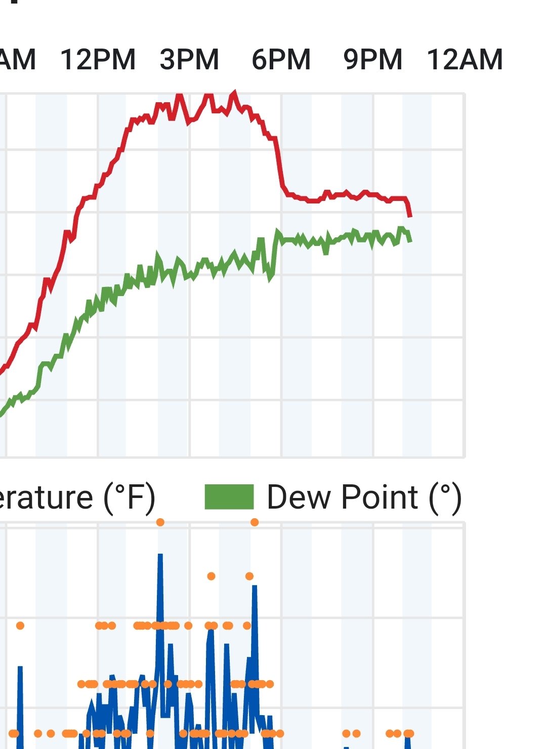
Kinda surprised, checked temp history and been at 35 past 3 hrs. Figured everything was gone, but went to get in the car and everything is still coated in a ice crusted slop of sleet.
-
Just switched over to rain here as well, right as the temp fell to 32.1
-
Ground has turned white here with sleet..still coming down at a good pace. 2"-3" piles on the deck from coming off the roof.
-
I'm just starting to get under the brightest returns here..ice chunks falling..sounds like hail hitting the roof..wouldn't even call it sleet (this is bigger)
-
CC has been holding right at the Monroe/Loudon line..I've stayed all sleet here, just a slushy dusting
-
Think it is bright banding based off CC, but if not somebody's still getting smoked
-
Agree..looks like it's gonna be a slush fest here (heavy sleet/33). Hard system for the southern valley to watch and be so close.
-
Station in Coker Creek is at 32/25 (1800'), starting to fall there...so no WAA above the southern valley yet (they usually jump first here)
-
My DP barely moved during the fall..should hopefully be a good sign up that way
-
Temp starting to fall off a cliff..33.8 now..will be super close, wetbulbing around 31-32
-
Got a slushy mess on elevated surfaces now, sleet..35
-
Moderate sleet falling now
-
Huntsville switched back to sleet